Curated OER
South America Map
For this South America worksheet, students view a blank map of South America that they can color or label. Students do this for all the countries in South America.
Curated OER
South America Map
In this South America political map learning exercise, students examine the country boundaries. The map also labels each of the countries and their capitals.
National Geographic
Mapping the Americas
Celebrate the geography of the Americas and develop map skills through a series of activities focused on the Western Hemisphere. Learners study everything from earthquakes and volcanoes of the Americas and the relationship between...
Curated OER
South American Quiz 2
In this South American worksheet, students complete short answer questions about the history and geography about South America. Students answer 10 short answer questions.
Curated OER
Blank Jeopardy: Brazil
Using a Jeopardy format, this game can help students review facts about Brazil. The presentation could be used as a complement to a middle school unit on South America.
Curated OER
Revolutions in Latin America (19c - Early 20c)
The history of the Latin American revolutions - and the philosophies behind them - is the focus of this comprehensive presentation. From the theories of the European Enlightenment, to the Revolutionary Wars of America and France, Latin...
Council for Economic Education
Economic Systems of the Incas and Aztecs
The Inca and Aztecs created vast economic empires in South America, but how did economics play a role? A simulation activity and reading help scholars evaluate the kinds of markets these great civilizations created. They then consider...
Curated OER
Welcome to the Americas
Students research and map the North and South American continents. In this geography lesson on the Americas, students can locate North, Central and South American countries and states. Students choose a location to research and prepare a...
Curated OER
Exploring South America
Young scholars research South American to prepare a PowerPoint presentation about its culture, traditions, and societies. In this South American research lesson plan, students research South American based on their export products to...
Curated OER
The Antebellum South
Your history students will be on the edges of their seats during this fascinating presentation, which details the abolition movement and slave life during the Antebellum period in the American South. Students will be left agape at the...
Curated OER
South America Commercials
Pupils create commercials that promote travel to South American countries in this middle-level lesson for the Social Studies classroom. The lesson suggests using educational software including MS Word, MS Powerpoint, and MS Publisher.
Curated OER
South America Map
For this South American political map worksheet, students examine both national boundaries and national capitals.
Curated OER
Spanish Colonies in South America
How did the Spanish govern its South American colonies? This presentation provides a series of questions, images, and an informative outline for learners to ponder. They will review the colonial caste system, the encomienda system, and...
Curated OER
Americas: Political Map
In this North America and South America outline map worksheet, students examine the political boundaries of the 2 continents.
Curated OER
Travel by Train: South American DVD Assignment
In this geography skills worksheet, students watch the National Geographic video "Travel by Train." Students then respond to 18 short answer questions about content in the video about South America.
Curated OER
Toco Toucan - Oil Pastels
Learners create a picture of a toucan from the continent of South America using a pencil, marker, and oil pastels. Students identify the continent of South America and discuss the Toco Toucan. They follow teacher directions to create...
Curated OER
South American Flags
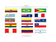
For this identifying flags from the countries in South America worksheet, students write the names of the countries under their flags. Students answer 15 questions.
Curated OER
Arts of the Americas
From deep in the jungles of Mesoamerica to the mound builders of North America, this presentation showcases the art of the Americas. It covers ancient American art, depicting architecture, ceremonial objects, art, and sculpture that span...
Richmond Community Schools
Map Skills
Young geographers will need to use a variety of map skills to complete the tasks required on this worksheet. Examples of activities include using references to label a map of Mexico, identify Canadian territories and European countries,...
Curated OER
South Asian Architecture
Seventh graders review and discuss architecture from South Asia. They then study images of various buildings from North Africa/Southwest Asia, and make comparisons
Curated OER
South Carolina Crossword Puzzle
In this crossword puzzle worksheet, students read the 8 phrases associated with South Carolina. Students then complete the puzzle with terms about South Carolina.
Curated OER
South Carolina Vocabulary
In this vocabulary activity worksheet, students read the 9 statements about South Carolina. Students use the words in the word box to complete the examples.
Curated OER
The European Conquest of the Americas
Witness the birth of the Americas in this presentation, which details the European Explorers who contributed to adding vital details on our modern-day maps. Viewers' worlds will literally expand after seeing the results of Cortes and the...
Curated OER
South American Outline Map
In this blank outline map worksheet, students study the political boundaries of the continent of North America and those of the countries located there.


