Curated OER
Abigail Adams: Integrating Social Studies and Language Arts
Third graders increase reading strategies while learning about Abigail Adams and her role in history. In this Abigail Adams lesson, 3rd graders read about the American Revolution and Abigail Adams using all the balanced literacy...
Curated OER
Northeast States and Tribes Word Search
In this geography instructional activity, students find the words that are used to describe places in the Northeastern United States. The answers are found at the bottom of the page.
Curated OER
What and Where is Puerto Rico?
Learners explore Puerto Rico. They create K-W-L charts of their prior knowledge of Puerto Rico and observe maps of Puerto Rico. They code the map for measurements and land and water forms. They explore websites to gain background on...
Curated OER
Border to Border
Students use the Internet to gather information on the country of Mexico. They also discover the culture of their people and compare them with the United States population. They take a virtual tour of some of Mexico's most historical ruins.
Dade Schools
Ancient Greece
What role does geography play in the development of a culture? How does ancient Greek culture still influence civilization today? These and other questions are explored in a unit study of Ancient Greece. The overview of the unit provided...
Curated OER
Unit of Study Mural
Pupils make a mural after reading about the art of Diego Rivera. For this mural lesson plan, students read a book about Diego Rivera, discuss him and his artwork, and make their own class mural.
Curated OER
Globe Lesson 17 - Alaska and Hawaii - Grade 4-5
Students develop their globe skills. In this geography skills lesson, students explore the area added to the United States when the Alaskan territory was purchased from Russia.
The New York Times
Kiev in Chaos: Teaching About the Crisis in Ukraine
Provide a historical context for the political unrest between Russia and Ukraine that began in late 2013. Learners review their prior knowledge and chronicle new understandings with a KWL chart, watch a video explaining the Ukrainian...
Curated OER
Globe Skills Lesson 1 Some Early American Cultures
Young scholars apply their knowledge of geography. In this geography skills lesson, students read brief selections regarding early Americans. Young scholars respond to the questions included in the self-guided map skills lesson.
Curated OER
Globe Skills Lesson 4 The Colonial Period
Students practice their map skills. In this Colonial geography lesson, students complete an activity that requires them to locate English colonial locations using latitude and longitude coordinates.
Curated OER
Globe Skills Lesson 11The Vietnam War
Students develop their globe and map skills, In this geography lesson, students examine the Vietnam War as they complete an activity that requires them to plot latitude and longitude.
Curated OER
Leaders, Laborers, and Other Perspectives of World War II
How did the women in France feel about their country’s involvement in World War II? Class groups are assigned a country involved in WWII, and individuals within the group adopt the point of view of leaders, laborers, businessmen, women,...
Curated OER
Simulated Underground Railroad Experience
Students participate in a unit that focuses on the Underground Railroad of the Civil War Period of History. The intent of the unit is realized in the culminating activity of going to many different stations to interact for different...
Curated OER
Revolutions in Latin America: Bolivar, 1813-1814
High schoolers compare the leadership skills of Washington and Bolivar. In this Latin American history lesson, students read biographical information about George Washington and Simon Bolivar. High schoolers compare the men to better...
Concord Consortium
Center of Population
Let the resource take center stage in a lesson on population density. Scholars use provided historical data on the center of the US population to see how it shifted over time. They plot the data on a spreadsheet to look the speed of its...
Curated OER
Social Studies: Looking at Regions
Quiz your 3rd graders on why we have regions. This regions quiz includes 16 questions on why and how we group areas into regions based on physical features, culture, politics or religion. A class discussion on technology completes this...
Curated OER
Trading Faces
Students use addition to determine values of coin combinations. They play a game where they come up with possible trades: two nickels for a dime and complete a tally worksheet. There are other lessons in this unit.
Curated OER
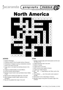
North America Puzzle
In this geography activity, students complete a crossword puzzle in reference to North America. They identify capitals of some countries, the specific landforms of different areas, and languages spoken. There are 21 clues to solving the...
Curated OER
North America Puzzle Answer Sheet
In this geography worksheet, students name the capitals of various countries found in North America. They also identify the various weather patterns across the continent and specific bodies of water. There are 21 descriptions and 21...
Curated OER
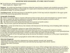
Advertise With Geography...it's Free And It's Easy!!
Students establish awareness of how landforms/landmarks produce a visual image of a region and demonstrate how advertisers use the "positive geographical image" to sell their product by creating their own advertisements.
Curated OER
I Can Compass, Can You?
Students discover how to use geographic tools. In this compass lesson, students identify cardinal directions by appropriately using compasses along with a number of various maps.
Curated OER
Globe Skills Lesson 5
In this map skills learning exercise, learners read a text selection about locations during the American Revolution and then respond to 8 fill in the blank questions.
Curated OER
Riding With Alice
Student listen to Don Brown's, Alice's Grand Adventure before discussing cross country travel. They trace Alice's travels on an outline map of the US and focus on the state of Indiana. They color and label the counties that Alice...
Curated OER
Sing a Song of Coinage
Students examine the Tennessee state quarter. They discuss Tennessee's musical heritage, examine all of the coins and as a group, create a song about coins or money. They also complete worksheets pertaining to the lesson.


