Curated OER
Moon Mining
Go on a moon mining expedition from the safety of your classroom with this space exploration simulation. Using simple models of the moon's surface prepared ahead of time by the teacher, young scientists are challenged with locating and...
Curated OER
Investigating the Climate System: Energy, A Balancing Act
Earth science explorers design an experiment to demonstrate that the albedo of a surface affects its temperature. They test to find out if moisture on the surface affects temperature. They discover whether or not concrete or asphalt heat...
Curated OER
Exploration of the Americas
Third graders demonstrate knowledge of exploration by naming and describing accomplishments of explorers. They use the internet to find corresponding information on the explorer and fill in a chart that is provided. Students also...
Curated OER
Texas Commemorative Maps: Honoring Our Past
To celebrate Texas, groups plan and create a commemorative map for a topic or theme in Texas history. The richly detailed plan and the approach could easily be adapted to any state. Samples are included.
Curated OER
Call to Arms: A Service Project
Sick of selling candy and washing cars? How about hosting a Digital Day or a Learning Lunch? The suggestions here make fund raising fun and rewarding. Raise money to preserve important maps and other primary source documents.
Social Studies Coalition of Delaware
Urban Mouse Rural Mouse
Explore rural and urban environments over the course of four days. Each day offers a new look into how both environment compare and contrast. Activities include the observation and analyzation of images, a read aloud and grand discussion...
Middle Tennessee State University
Fights, Freedom, and Fraud: Voting Rights in the Reconstruction Era
As part of a study of post Civil War era, young historians investigate the changes in voting rights during the Reconstruction Era (1863-1876), the fraud involved in the Hayes-Tilden presidential election of 1876, and efforts by Pap...
Energy for Keeps
The Energy Times
Extra! Extra! Read all about past and present energy use in a classroom-made historical newspaper. Useful as a cross-curricular assignment between science, history, and language arts, the project is sure to get young journalists...
John F. Kennedy Presidential Library & Museum
Red States/Blue States: Mapping the Presidential Election
Young historians investigate how voting patterns have changed by comparing the outcome of the 1960 election to the outcome of the recent election. A creative final assessment has participants making a news show wherein they provide...
Curated OER
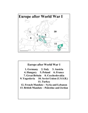
Europe after World War I
In this Europe after World War I map worksheet, young scholars note the 11 regions of the Europe labeled on the map.
Curated OER
This Land Is Our Land
Young scholars research federal land holdings. They explore how those lands are used. They map these lands and design their own legends. They discuss whether or not the land is being used accordingly.
Curated OER
Extreme Elevations
Seventh graders use highest and lowest points of land elevation around the world to find the differences. Sea level is zero, so students be operating with positive and negative numbers. After students find the information on the...
Curated OER
China is Unique
Sixth graders study the culture of China by comparing it to that of the United States. They write all questions and notes in a journal. The students access the internet to obtain the information and internet sites are suggested in the...
Curated OER
Agriculture & Alaska's Economy
Learners examine Alaska's agriculture numbers from previous years. They answer questions based on Alaska's production levels.
Curated OER
Corn Exports Visually
Students study imports and exports and the countries that import the most corn from the U.S. They construct mini paper corn plants and label a map with these plants to represent the amount of corn the U.S. exports to countries around the...
Curated OER
Mapping Perceptions of China
Students discuss what types of things are included on a map. They compare and contrast maps of China with a map they create and practice using different types of maps. They write analysis of their classmates maps.
Curated OER
Technology Integration
Third graders describe and locate the five geographical regions of the state of Virginia. Using that information, they organize the descriptions in a database they created. They are graded based on accuracy and spelling all noted on a...
Curated OER
Population Pyramids
Young scholars explain the significance of population trends on world regions. They define relevant population vocabulary and examine age-gender patterns at various scales.
Curated OER
Race and Ethnicity in the United States
Students explore race and ethnicity as it is defined by the U. S. Census Bureau. They compare data from 1900, 1950, and 2000 and identify settlement patterns and changes in population. In groups, they map these changes and discuss...
Curated OER
Where Does It Come From?
Students explore where agricultural commodities used in snack foods are grown. They choose a snack food and locate the top five states that produce the food that the snack is made from.
Curated OER
Right on Time
The hour is nigh for your class to practice equivalency problems in the form of time-zone conversions. They write equations to describe elapsed time and apply problem solving strategies, including writing a plan, to solve the problems.
Curated OER
Potential Consequences of Climate Variability and Change
Students examine the potential impact of climate change to agriculture, coastal areas, forests, water, and human health. They hypothesize what might happen to a sugar maple forest and hold a debate about global warming.
Curated OER
Development on the Edge of a City
Students explore and analyze examples of changing relationships between patterns of settlement and land use in the state of Minnesota. They view different avenues of transportation, cities, suburbs, city planners and suburbanization.
Curated OER
Enduring Cultures
Students research the art, dance or a game from the Pacific Northwest Coast Aborigines. In this Canadian Cultures lesson, students view a PowerPoint about the Inuits. Students choose a game , type of artwork or dance to research....


