Curated OER
El Mundo Hispano
Welcome to the Spanish-speaking world! Show your learners which countries declare Spanish as their primary language. Included are maps and flags for each Hispanophone country.
Curated OER
El Salvador: How Can My Breakfast Harm the Birds?
Sixth graders explore how their food choices can have an impact on the rain forests. They examine coffee farming and how their techniques can harm birds in the rain forest. Students design two farms with sustainability of bird habits in...
Curated OER
Learning From El Salvador's Past
Students analyze El Salvador's history and the conditions that contributed to its civil war. identify the factors that led to the churchwomen's murder. Make determinations about the future of El Salvador's political and social climate...
Curated OER
Central America Map Quiz
In this online interactive geography quiz worksheet, students examine the map that includes 22 Central American countries. Students identify the names of the countries in 3 minutes.
Curated OER
Atlantic Basin Hurricane Tracking Chart
In this science worksheet, students look for the location of various storms that develop in the Atlantic Ocean with this hurricane tracking map.
ProCon
Sanctuary Cities
Should sanctuary cities receive federal funding, or do they defy federal laws? That is precisely the question scholars attempt to answer as they prepare for a class discussion or debate. After reading some brief background information,...
Curated OER
Drifting Continents
In this plate tectonics instructional activity, students study the continents map and complete 8 short answer questions related to them. They predict what the Earth will look like millions from now.
Curated OER
Latin America: Places and Regions
Seventh graders create a Latin American portfolio in the form of a country presentation using PowerPoint software. They use their knowledge of geographic concepts to interpret maps, globes, charts, diagrams, and timelines.
Curated OER
Old Mayan Mural
Students read a story called Scientists Discover Oldest Mayan Mural and answer vocabulary and comprehension questions about it. In this current events Mayan mural lesson plan, students respond to literature by answering questions,...
Curated OER
Dia de la Independencia
Students learn about Mexican Independence Day. In this Hispanic Heritage instructional activity, students learn about holidays in Hispanic countries specifically looking at their days of independence. Students read information about...
Curated OER
Geograophy of Mexico And Central America
Students create a chart comparing the terrain, climate, economy, environmental issues and natural disasters for Mexico and the Central American countries. They view and discuss a video on the region then compile research on the internet.
Central Intelligence Agency
Cia: World Factbook: El Salvador
This resource from the CIA World Factbook provides a detailed fact sheet of El Salvador. The content covers the country's geography, people, government, economy, communications, transportation, military, and transnational issues. It...
Biblioteca Virtual Miguel de Cervantes
Biblioteca Virtual Miguel De Cervantes: El Salvador
This resource site in Spanish for the country of El Salvador. The flag and a general map of the country are included. Of particular interest is the statistical data available on land size, climate, population, life expectancy, infant...
Latimer Clarke Corporation
Atlapedia Online: El Salvador
A complete profile of the Republic of El Salvador including highlights on its geography, climate, people, modern history, economy, communications, and military. Click on the maps to enlarge them.
Nations Online Project
Nations Online: El Salvador
Presents a country profile of El Salvador, background details, and numerous links to comprehensive information on the nation's culture, history, geography, economy, environment, population, news, government, and much more.
AllRefer
All Refer Reference: El Salvador: Introduction & Country Profile
Profiled here is the Central American country of El Salvador. Basic facts are furnished for topics that include: geography, economy, government, people, military, history, a map, and a flag.
Hans Lohninger
Photo Globe: El Salvador
Discover some interesting basic facts about El Salvador with this helpful site.
Climate Zone
Climate of El Salvador
A valuable guide to climate information in El Salvador broken down by stations. Information includes average monthly temperature and rainfall. Some general facts and a map are also featured.
Houghton Mifflin Harcourt
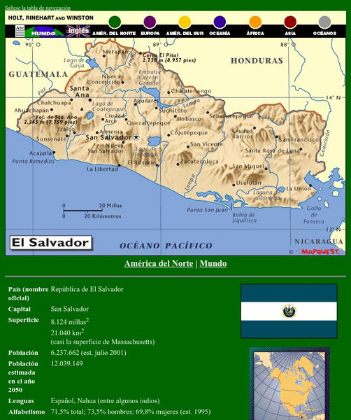
Holt, Rinehart and Winston: America Del Norte: El Salvador
This site has a map of El Salvador in Spanish, with informational data also presented in Spanish about the country. Land mass, population, life expectancy, literacy, industry, agriculture, minerals and resources are among the topics...
Encyclopedia of Earth
Encyclopedia of Earth: El Salvador
The Encyclopedia of Earth provides an overview of El Salvador, including its geography, natural resources, history, government, economy, and much more. Maps and images are also included, along with sources used to create the entry.
Curated OER
Science Kids: Science Images: Map of El Salvador
A map featuring El Salvador and its neighboring countries.
Curated OER
Map of El Salvador
BBC furnishes an overview, facts, leaders' information, and a media list for El Salvador. Provided is a link to a detailed timeline of events and the audio of the national anthem.
Other
Map Town: Maps for Central America
Here are all seven Central American countries plus Mexico at a glance. Study a map or just general information about one of the countries.


