Mr. Head's 6th Grade Classroom
Absolute Location
How do we know where we are in the world? A presentation for middle schoolers explains absolute location and other geography terms such as relative location. It also gives scholars the opportunity to practice finding absolute location on...
Curated OER
Learning About Location: Charting the Path of the George W. Elder
Students acquire a working knowledge of the geographical concepts: absolute location, relative location, longitude and latitude. They analyze primary sources that shows the physical and human characteristics of the places along the 1899...
Curated OER
Absolute Location Using GPS Technology
GPS is great for identifying your position, but is it finding your relative or absolute location? Ninth graders explore the difference between absolute and relative location, use the standard grid system coordinate system, and use GPS to...
Curated OER
Where In the World Am I?
Learners identify their location in the world after studying latitude, longitude, relative location, and absolute location. They use assigned web site to find information to make a flipbook that answers questions about their location in...
Geography for Geographers
Five Themes of Iceland
How do the five themes of geography relate to the country of Iceland? Pupils learn about everything from the differences between relative and absolute location to how humans both adapt and change the environment. The presentation...
Curated OER
Where are We?
Fifth graders explore places visited by Lewis and Clark. In this geographical concepts lesson plan, 5th graders plot places on a map and put events in chronological order. Students find locations on a map using longitude and latitude....
Prestwick House
The Absolutely True Diary of a Part-Time Indian
Sherman Alexie's coming-of-age social commentary is the focus of a review activity. Learners use clues from The Absolutely True Diary of a Part-Time Indian to complete a crossword puzzle about the novel.
Curated OER
Plotting A Hurricane Using latitude and Longitude
Students explore map and plotting skills by tracing the movement s of hurricanes through the Earth's systems. a hurricane map is developed from daily media reports.
BrainPOP
Latitude and Longitude Differentiated Lesson Plan
Scholars warm-up their map skills with a discussion using location words to describe familiar places. An engaging video informs class members about latitude and longitude. Three leveled activities extend the learning experience for...
Illustrative Mathematics
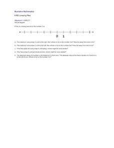
Jumping Flea
Mathematics minors consider the magnitude of a jumping flea as he hops from place to place. Through this exercise, they will investigate absolute values, as well as positive and negative rational numbers on a number line. The first page...
Agile Mind
Cake Weighing
An online set of four yummy questions addresses number sense for sixth graders. They place points on a number line, determine relative values, interpret absolute value, and apply their understanding to the weighing of cakes for a bakery....
Illustrative Mathematics
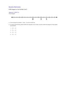
Integers on the Number Line 2
Four inequality statements are given for the same two negative numbers. The resource is a good practice for pupils to interpret statements of inequalities relative to the position on the number line. The objective is for pupils to learn...
US Mint
Absolutely and Relatively: The Puerto Rico Quarter Reverse
How much does your class know about Puerto RIco? How much can they learn from the back of a 2009 quarter? Use the coin, part of a series of quarters that depict US territories, to teach learners about the geography, culture, and history...
Curated OER
Absolute and Relative Location
Second graders understand the difference between relative and absolute location using the grid map as an example of an absolute location. They observe a class map showing longitude and latitude lines and learn that they provide exact...
Curated OER
Where In The World Is Bermuda?
Young scholars locate the Island of Bermuda, and identify its absolute and relative location.
Curated OER
Tectonic Plates, Earthquakes, and Volcanoes
Challenge geography classes to locate the major volcanoes and earthquake faults on a world map. In groups, they identify the pattern made and examine the relationship between the locations of the faults and volcanoes and tectonic plates....
Curated OER
How Big is Big?
Geography learners compare and contrast population densities throughout the world. Using maps, they estimate the relative size of the world's regions and populations. They develop analogies to discover the world they live in and...
Curated OER
Absolute And Relative Location
Students create a map that takes someone from school to their home using both relative and absolute locations. They assume the person using the map is unfamiliar with the area.
Curated OER
Nunavut, Our Communities
Students locate the communities of Nanavut on a territorial map and identify community characteristics. They research the online Atlas of Canada
Curated OER
What do Maps Show?
Eighth graders practice the skill of reading maps. In this geography instructional activity, 8th graders participate in a classroom lecture on how to read a map.
Rice University
Algebra and Trigonometry
Move on into trigonometry. An informative eBook takes the content of a College Algebra course and adds more relating to trigonometry and trigonometric functions. The content organization allows pupils to build upon their learning by...
Curated OER
Some Things You Need to Know to Read a Map
Young scholars study things the you need to know to read a map and explain location.
Curated OER
Geography/Current Events Project
Using the Balkan region as an example, fourth graders review the five themes of geography as a class. They identify the physical and human characteristics of a region before labeling the countries and landforms on a map. They then...
Curated OER
Comparison of hometown life with that of life in a Canadian city
Students research cultural characteristics of a Canadian city with that of their home town. They complete a map handout, providing the relative location on a large map and the absolute location on a provincial map. Students work together...


