Curated OER
Europe Labeled Map
In this Europe political map worksheet, students examine the national boundaries. The map also highlights each of the nation's capitals with a star. The countries and capital cities in this map are labeled.
Curated OER
Map Activities
In this geography worksheet, students follow the directions and shade 3 different regions of a UK political map, shade European Union countries on a political map of Europe, match 4 physical feature of Africa to their descriptions, and...
Curated OER
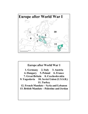
Europe after World War I
In this Europe after World War I map worksheet, pupils note the 11 regions of the Europe labeled on the map.
Curated OER
2 Cities: Europe's Capital Cities
For this European cities worksheet, learners label the countries and then provide an alphabetical key for each country. Students then label each capital city and provide a numerical key for each city.
Curated OER
Kosovo: Where is It and What's All the Fuss About?
High schoolers investigate the US military involvement in Kosovo and answer teacher generated questions.
Other
Bike About the Mediterranean
The creators of this site biked through many countries in the Mediterranean region from 1997 to 1998 and describe here their journey. Along the way, they visited many cultural sites and schools and reported here about their experiences....
Soft Schools
Soft Schools: Europe Countries and Capitals Quizzes
Choose from four interactive quizzes, and test your geography knowledge of European countries and their capitals.
Encyclopedia of Earth
Encyclopedia of Earth: Belarus
Provides an overview of Belarus, including its geography, natural resources, history, government, economy, and much more. Maps and images are also included, along with sources used to create the entry.
University of Texas at Austin
Perry Castaneda Library Map Collection: Historical Maps of Europe
This collection from the University of Texas Library Online of historical maps contains a wide variety of maps from various parts of Europe and from different parts of history. Each map is accompanied by a brief description and is clear...
World Geography Games
World Geography Games: Countries of Europe
Test your knowledge of European geography.
Science Struck
Science Struck: How Many Countries Are There in Europe?
Presents a map and a list of all the European countries, along with their capitals, land area, population, language, and currency.
Science Struck
Science Struck: A Complete a Z List of All the European Countries
An alphabetical list of all the European countries with short descriptions stating their capital, population, political system, currency, and languages spoken.
Encyclopedia of Earth
Encyclopedia of Earth: British Indian Ocean Territory (United Kingdom)
Provides an overview of British Indian Ocean Territory (United Kingdom), including its geography, natural resources, history, government, economy, and much more. Maps and images are also included, along with sources used to create the...
Cool Math
Coolmath: Coolmath Games: Map Snap: Europe
You are presented with an outline map of Europe and you must place each country in its correct position. It clicks into place if you're in the right spot. You may want to start with the practice mode which has the shape outlines of the...
Lizard Point Quizzes
Lizard Point: Test Your Geography Knowledge: Europe
This resource is a way to test yourself, and your students, on their geography knowledge of Europe.
Other
Harper College: Map Quiz Tutorial
A great way to learn about and then test yourself on Europe's geography. Includes three map tutorials. Good tool for visual learners!
Science Struck
Science Struck: A to Z List of European Countries and Their Capitals
Presents a map and an alphabetical list of all the European countries and their capital cities.
Science Struck
Science Struck: List of European Capital Cities With Countries
Discusses the geography of Europe and presents a table of 51 European countries and their capitals and a second table of 12 autonomous regions and their capitals.


