Curated OER
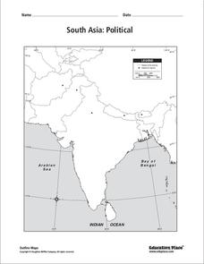
South Asia: Political Map
In this South Asia political map worksheet, students examine the national boundaries. The map also highlights each country's capital city.
Curated OER
South America Map
For this South America political map worksheet, students examine the country boundaries. The map also labels each of the countries and their capitals.
Curated OER
World: Physical Map
In this world physical map learning exercise, students make note of the major landforms located on this Robinson projection map.
Curated OER
US: Northeast Region Map
In this United States political map worksheet, students examine the state boundaries of the Northeast Region. The map also highlights each of the state capitals denoted by stars.
Curated OER
US: Northeast Region: Unlabelled
In this United States political map instructional activity, students examine the Northeast Region state boundaries. The map also highlights each of the state capitals denoted by stars.
Curated OER
United States of America Map: Capitals
In this United States outline map worksheet, students note the political boundaries of the states that are labeled with postal abbreviation codes as well the labeled state capitals.
Curated OER
United States of America: 1860
In this United States historical map worksheet, students examine the boundaries of the labeled states and territories of the nation in 1860.
Curated OER
Africa & Asia: Labeled Map
In this African and Asian political map worksheet, students examine national boundaries and national capitals of the continents.
Curated OER
United States of America: 1860
In this United States historical map worksheet, students examine the boundaries of the states and territories of the nation in 1860. This map is unlabeled.
Curated OER
Central America: Unlabeled Map
In this Central American political map instructional activity, students examine the boundaries of the countries and capital cities located in this region of the world.
Curated OER
Mexico: Political Map
In this Mexico political map activity, students examine state boundaries. The map also highlights major cities in Mexico.
Curated OER
Canada: Outline Map
In this Canadian political map worksheet, students examine Canada's province boundaries. The map also highlights each of the province's capitals with a star.
Curated OER
Central America Map
In this Central American political map worksheet, learners make note of national boundaries and capitals in this region of the world.
Curated OER
Mexico: Political Map
For this Mexico political map worksheet, students examine state boundaries. The map also highlights major cities in Mexico. This map is unlabeled.
Curated OER
North America: Political Outline Map
In this North America political map worksheet, students examine the state and province boundaries of Mexico, Canada, and the United States.
Curated OER
North America Map
In this North America political map worksheet, learners examine the labeled countries and their respective national boundaries.
Curated OER
North America: Unlabelled Map
In this North America political map worksheet, students examine the unlabelled countries and their respective national boundaries.
Curated OER
Europe Labeled Map
In this Europe political map worksheet, students examine the national boundaries. The map also highlights each of the nation's capitals with a star. The countries and capital cities in this map are labeled.
Curated OER
North America Map
In this North America outline map learning exercise, students examine the political boundaries and identify the countries of North America.
Curated OER
Former Soviet Map Quiz
In this outline map quiz worksheet, students examine the provided map and label the noted countries that used to be part of the former Soviet Union.
Curated OER
England Outline Map
In this outline map worksheet, students examine the political boundaries of the England. The map may be used in variety of activities that individual teachers create to accompany it.
University of California
Us Geological Survey: Cartogram Central
The USGS offers detailed information on Types of Cartograms, Congressional Districts, Software for Cartograms, Publications, and a Carto-Gallery.
National Endowment for the Humanities
Neh: Edsit Ement: Mapping Our Worlds
In this lesson, introduce your students to the world of maps and discover a world of information online. Students learn how to identify different types of maps, comparing maps to the rooms of a house.
abcteach
Abcteach: Maps
[Free Registration/Login Required] Find outline maps of the continents and the United States and Canada, as well as other country and city maps.


