Curated OER
I Can Find that Where? - A Study of Landforms
First graders make landform maps of the United States. In this landform lessons, 1st graders participate in a discussion of local landforms and make a landform map of the United States. They follow the teacher's directions to add plains,...
Curated OER
Mapping My World
First graders make two maps. For this developing and reading maps lesson, 1st graders read Mapping Penny's World, discuss the parts of a map, create a map of their classroom, and create a list of directions of how to get to various...
Curated OER
Cardinal Directions
First graders study cardinal directions on maps. In this geography lesson, 1st graders determine and show where North, South, East, and West are on various maps.
Curated OER
Where are We?
Fifth graders explore places visited by Lewis and Clark. In this geographical concepts lesson plan, 5th graders plot places on a map and put events in chronological order. Students find locations on a map using longitude and latitude....
US Mint
Absolutely and Relatively: The Puerto Rico Quarter Reverse
How much does your class know about Puerto RIco? How much can they learn from the back of a 2009 quarter? Use the coin, part of a series of quarters that depict US territories, to teach learners about the geography, culture, and history...
Curated OER
Mapping the News
Students explore cartography. In this map skills and map making lesson, Students work in groups to create wall size world maps including legends, compass roses, latitude and longitude, and physical features. Students collect current...
Curated OER
Our World With MapsQ
Learners examine and compare different types of maps. In this map skill lesson, students look at neighborhood and national maps on the overhead projector while making comparisons of the symbols and locations. They use a T-chart to record...
Curated OER
From Claws to Jaws: Atlantic Regions of the United States
Students explore New England, Mid-Atlantic, and southeastern regions of the United States. In this social studies thematic unit, students research a state and make a regional quilt. Students wrte a book report and read two novels whose...
Curated OER
As a Bird Flies or as a Submarine Dives...
In this geography worksheet, students look critically at a map containing a variety of different directions. Students answer 2 short answer questions regarding giving someone the best directions from point A to point B.
Curated OER
Plot Your Course
High schoolers determine distance and direction on a nautical chart. In this nautical instructional activity, students identify obstacles and characteristics of common aid to navigation on a nautical chart.
Curated OER
Drake's West Indian Voyage 1588-1589
Young scholars investigate several maps detailing Sir Francis Drake's voyages. In this geography lesson, students practice reading maps and locating the precise locations of where Sir Francis Drake visited. Young scholars create an...
Curated OER
Where Is Rome?
Third graders discover Ancient Rome through maps and worksheets. In this world history lesson, 3rd graders locate Rome on a world map and identify the scope of the Roman Empire. Students label an entire map of Italy after printing one...
Curated OER
Latitude and Longitude
Students demonstrate how to locate places on a map using a grid. In this map skills lesson, students are introduced to latitude and longitude lines. Students define these terms and view a large map of a state. Students come up to the map...
Curated OER
Lesson 3: Seven Day Road Trip
Students plan a seven day road trip. In this travel lesson, students plan a driving trip that includes five major cities or attractions in Florida or another state of their choice. They show the trip on a map, calculate distances that...
Curated OER
Map Skills
Students create two types of maps. In this map skills lesson, students discuss map vocabulary and view maps of Florida. Students draw a free hand map of Florida and include major cities, bodies of water and land forms. Students work...
Curated OER
Time Zones
Students solve time zone problems and chart travel around the world. In this time zone lesson, students learn about the history of time zones and view a time zone map. Students use the time zone map to solve time zone problems. ...
Curated OER
Down at the Orchard
First graders examine what an apple orchard looks like and work with cardinal directions. In this apple orchard and direction instructional activity, 1st graders listen to Anne Rockwell's, Apples and Pumpkins, and Amy and Richard...
Curated OER
The Country of Kenya
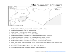
In this map completion worksheet, students observe a map and map scale of Kenya to find and label bodies of water, cities, countries, and the equator. Students answer 11 questions.
Curated OER
Where in the World
Students explore the global grid system. In this globe lesson, students identify latitude and longitude lines and how these can tell the coordinates of any place. They use the Internet to find the exact coordinates for their town.
Curated OER
Maps and Legends by Micheal Chabon
Students read an essay to improve language skills and understanding of American culture for ESL teachers. In this American culture lesson, students read the essay 'Maps and Legends' by Michael Chabon and complete various activities to...
Curated OER
Student Exploration: Summer and Winter
In this recognizing the seasons online/interactive instructional activity, students explore the Earth's positions and determine the summer and winter season. Students answer 21 short answer questions
Curated OER
Terrabagga Activity using a Magnetometer
Students use a magnetometer to determine the orientation of a magnetic field. In this magnetism lesson, students build a simulated planet and use a simple magnetometer to determine the orientation of their planet's magnetic field.
Curated OER
Mapping the Transcontinental Journey
Students develop their geography skills. In this Lewis and Clark instructional activity, students collaborate to calculate the time and distance of different segments of the expedition. Students compare their estimate to Lewis and Clark's.
Curated OER
Where in the Latitude Are You? A Longitude Here.
Students distinguish between latitude and longitude on the map. In this mapping lesson, students participate in mapping skills to recognize spatial relationships, and where to find natural resources on the map. Students create their own...


