Curated OER
Chile's Trapped Miners
Students read an article on trapped miners in Chile. For this social awareness ELL lesson, students read the details about how 33 miners had to be rescued in Chile when they got trapped underground. Activities that reinforce the...
Curated OER
South America and Central America Map Quiz
In this online interactive geography quiz activity, students examine the map that includes all of Central and South America's countries. Students match each of the country names to the appropriate locations on the map.
Curated OER
South America and Central America Capitals Map Quiz
In this online interactive geography quiz instructional activity, students examine the map that includes all of Central and South America's countries. Students match each of the country names to the appropriate...
Curated OER
South America Map Quiz
For this online interactive geography quiz worksheet, students examine the map that includes all of South America's countries. Students identify the 13 countries in 2 minutes.
Curated OER
Mapping South America
Students explore South America. In this South American instructional activity, students use their geography skills to create population, terrain, biomes/vegetation, and major exports maps. Students present their finished maps to their...
Curated OER
Welcome to the Americas
Students research and map the North and South American continents. In this geography lesson on the Americas, students can locate North, Central and South American countries and states. Students choose a location to research and prepare a...
Curated OER
Countries of South America
Students focus on the geography of the countries of South America. Using a map, they identify the European countries who claimed the South American countries and research the influences they had on South America. To end the lesson...
Curated OER
Exploring the Biomes of South America
Sixth graders complete a five-week unit investigating the eight major biomes of South America. They conduct Internet research, collect short-term and long-term climate data, and create a HyperStudio slideshow stack about a selected biome...
Curated OER
Ecuadorian Highlands Lesson
Indigenous peoples resided in the highlands of Ecuador as far back as 5,000 B.C. To learn about the lives of these people, class pairs research the farming and the building methods, the arts and crafts, and the beliefs of the early...
Curated OER
Toco Toucan - Oil Pastels
Students create a picture of a toucan from the continent of South America using a pencil, marker, and oil pastels. Students identify the continent of South America and discuss the Toco Toucan. They follow teacher directions to create...
Curated OER
Taking the Lead
Students discover how officials are elected in countries of interest to them. After reading an article, they examine election fraud allegations in Peru. They create a poster showing the election process and assess them in a written essay.
Curated OER
South America Word Search
In this word search worksheet, students study the 14 words relating to South America. Students then find the words in the word search puzzle.
Curated OER
The Continent Game
Students order the continents in terms of area, population and other geographic terms.
Curated OER
First Nations Contributions
Seventh graders examine countries when they first became nations. In this Social Studies lesson, 7th graders investigate food that was present in North and South America. Students prepare a presentation on food for their...
Curated OER
Travel by Train: South American DVD Assignment
In this geography skills instructional activity, students watch the National Geographic video "Travel by Train." Students then respond to 18 short answer questions about content in the video about South America.
Curated OER
Brazil and the Amazon
Sixth graders examine the features of the country of Brazil. In this Geography instructional activity, 6th graders complete a graphic organizer on the geography of Brazil.
Curated OER
Geography of South America
Students explore South America. In this geography skills lesson, students watch a video about the geographical features of the continent. Students complete worksheets on the topic.
Curated OER
South America Outline Map
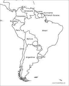
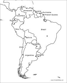
In this blank outline map worksheet, students explore the political boundaries of South America and the nations there. This map may be used in a variety of classroom activities. The map is labeled with the country names.
Curated OER
South America Outline Map
In this blank outline map worksheet, students explore the political boundaries of South America and the nations there. This map may be used in a variety of classroom activities. The location of the capital cities are denoted with...
Curated OER
South America Outline Map
In this outline map worksheet, students discover and investigate the physical boundaries of the countries in South America. The names of countries and a star to mark the capital city are included.
Curated OER
South America Outline Map
In this outline map worksheet, students discover and investigate the continent of South America. No country borders or physical features are depicted. This blank outline map may be used for a variety of classroom activities.
Curated OER
South American Outline Map
In this blank outline map activity, students study the political boundaries of the continent of North America and those of the countries located there.
Curated OER
Exploring South America
Students research South American to prepare a PowerPoint presentation about its culture, traditions, and societies. In this South American research instructional activity, students research South American based on their export products...
Curated OER
South America Map
In this South America worksheet, learners view a blank map of South America that they can color or label. Students do this for all the countries in South America.


