NOAA
Ocean Exploration
Where am I? The second installment of a 23-part NOAA Enrichment in Marine sciences and Oceanography (NEMO) program starts with pupils guessing the years in which major ocean exploration events took place. The lesson then focuses on how...
Curated OER
Geography Terms
Introduce the terms and concepts related to basic map and geography skills. Terms include full definitions and cover latitude, longitude, the Equator, Tropic of Cancer, Tropic of Capricorn, Prime Meridian, and the International Date Line.
Curated OER
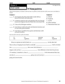
Viewpoints
In this latitude and longitude worksheet, students complete 10 matching questions identifying key features or locations on a map. Students also use lines of latitude and longitude to identify the time in 4 different places.
Curated OER
Understanding Latitude, Longitude, and Time Zones
Students take an imaginary world tour by locating cities with latitude and longitude. They plan an itinerary and calculate the time zones from which they would call home. Then they construct word problems involving travel across time zones.
Curated OER
Longitude
In this globe worksheet, students learn how longitude is measured on a globe. Students read the information before answering 5 questions. A globe will be required.
Curated OER
Time Zones
Students are able to read and also use a variety of timetables and charts. They perform calculations with time, including 24-hour clock times and time zones. These are very important concepts that Students probably have to bear in mind...
Curated OER
Viewpoints
In this map worksheet, students review latitude, longitude, equator, and prime meridian. This worksheet has 5 matching and 8 fill in the blank questions.


