Curated OER
Topographic Maps
In this topographic map worksheet, students learn how to read a topographic map and create a topographic map of their own using clay or Play-Doh. Students include contour lines by layering the clay. Students answer 6 questions about...
Curated OER
Trailblazers- Now and Then
Students examine and study the routes of trailblazers. In this American history lesson, students find a route on a map and compare that to the route of trailblazers. Students will then compare that map with a topographical map to...
Curated OER
Barton Lake
For this lake depth worksheet, students use a topographic map to determine the depth of the Barton Lake at various points. This worksheet has 8 fill in the blank questions.
Curated OER
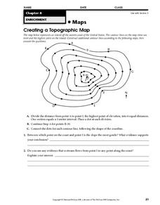
Creating a Topographic Map
In this topographic map activity, students add contour lines to a topographic map using instructions provided. Once topographic map is finished, students complete 2 follow-up short answer questions.
Curated OER
Maps Reinforcement
In this map activity, students complete 6 multiple choice questions and 5 short answer questions about 3 different map figures.
Curated OER
Topography of Africa
Students study Africa's diverse landscape and investigate how these features impact the available water supply, food sources, and population distribution of the continent. They compare topographical features and
their affect on each...
Curated OER
Orienteering
High schoolers acquaint with co-participants and identify the practice basic compass functions and orienteering procedures. They also work together to solve a small challenge. Students then identify how the challenge of orienteering...
Curated OER
Topographic Mapping
Learners create a three dimensional model of a two dimensional topographic map. They explore how the two dimensional significance of a topographical map is helpful to create a three dimensional model. Students use other topograhical...
Curated OER
Candy Bar Subsurface Geology
Students are introduced to drawing and interpreting topographical maps. They each cut through there Jell-o mountain at regular height intervals, and trace around the shape of the Jell-o cut off at the height, overlaying the different...
Curated OER
Virtual Geologic Field Trip to Griffith Park
Students explore the geological processes and research methodology involved in the evolution and development of Griffith Park. They justify the selection of a geologic hypothesis based on observations.
Curated OER
Design an Island
Students explore islands. They create a two- or three-dimensional map of an island. They explain how the topography of an area influences the location of water sources, ecosystems, and human settlements. Lesson includes adaptations for...
Curated OER
Denali Park Topographic Maps
Young scholars construct a topographic map of the Denali National Park. They identify different elevations and record historic landmarks in student science journals.
Curated OER
MAPS AND TOPOGRAPHY
Students analyze the details of a topographic map and create one of their own by utilyzing a map of elevations.
Curated OER
Cookie Topography
Students construct a cross section diagram showing elevation changes on a "cookie island." Using a chocolate chip cookie for an island, they locate the highest point in centimeters on the cookie and create a scale in feet. After tracing...
Curated OER
Topo Map Mania!
Students read and use topographical maps. They also use a compass to find bearing to an object on a map and in the classroom. Ask your students how they might travel to somewhere they have never been to befo
Curated OER
GEOGRAPHY: SPACE CENTERS
Young scholars examine the descriptive science dealing with the surface of Earth, its division into continents and countries, climate, natural resources, inhabitants and industries of the various divisions and analyze the political...
Curated OER
Cookie Mapping
Students study the components of a bedrock geology map through a hands-on activity involving a cookie and graph paper.
Curated OER
A Shuttle's Eye View
Students explore the goals of the Shuttle Radar Topography Mission as a springboard to exploring the topographical features of their own state or region. They synthesize their understanding of landforms and topography by mapping their...
Curated OER
Weathering the War
Learners research maps, weapons and weather from a variety of wars, then create a presentation showing the impact weather and topography has had on military operations.
Curated OER
Contour Map Worksheet #4
There are only four questions here. There is a contour map of Cottonwood, Colorado and the creek that crosses it. Earth scientists tell in what direction the creek flows, identify the highest elevation on the map, draw a topographic...
Curated OER
Gallery Walk Questions on Weathering and Mass Wasting
A set of questions on weathering and erosion are found in this resource. Some of them can be used as discussion topics or lecture guides. There are also suggested activities such as the examination of topographic quadrangles and the...
Curated OER
Working With Electronic Topography Maps
Junior geologists examine topographic maps online and learn how to read them. they answer seven associated follow-up questions. This lesson plan is only a general outline and does not provide the details or the websites that you...
Curated OER
Common Themes
Tenth graders test usefulness of a model Earth by comparing its predictions to observations in the real world. In this landforms lesson students construct an island from a contour map using model clay then analyze the landscape...
Curated OER
Salad Tray 3D Topographic Model
Students explore the characteristics of topographical maps. They examine the relationship of contour lines and vertical elevation. Students create a three-dimensional model of a landscape represented by a topographic contour map.


