Curated OER
Continents
Students investigate World Geography by researching the different continents. In this Asian Geography lesson, students discuss the continent of Pangaea and color a worksheet of the continents. Students locate China on the map worksheet...
Curated OER
Where Do Canadians Live?
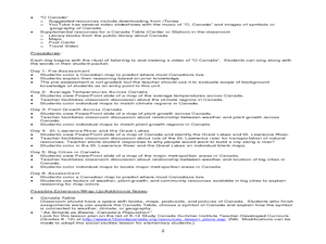
Students investigate Canadian people by researching the geography of the country. In this world geography lesson, students identify locations within Canada with large populations based on their access to waterways. Students view and...
Curated OER
How Worldly Are You?
Sixth graders locate and map six components to have a working knowledge of maps. In this map skills lesson, 6th graders define the six map components and work in groups to draw a map using the components. Students read a related story...
Curated OER
Region Reality
Eighth graders compare and contrast world regions and explore the theme of world regions. In this world geography lesson, 8th graders name regions in the U.S. and mark them on a map. Students discuss the cultural and physical...
Curated OER
Read a Transportation Story
Eighth graders research the career of Arctic transportation. In this arctic transportation lesson, 8th graders read a book about Arctic truck travel and review the historical aspects of transporting goods in the Arctic. Students review...
Curated OER
Geography: Ancient Rome
Students research Ancient Rome, the Mediterranean Region, Roman myths, and Latin. In this Roman life lesson, students study maps of the region, learn their language and customs, research the Punic wars, the catastrophe of Pompeii, and...
Curated OER
Political Legends and Map Symbols
Students identify the legend and map symbols. In this map skills lesson, students use a world map to find various locations using a map key.
Curated OER
Simulation: River Cruise: Rivers of the World
Students identify major rivers in the world. In this geography lesson, students form teams and play a whole class board game in which clues are read and rivers are identified.
Curated OER
World: Political Map
In this world political outline map worksheet, students examine boundaries of each of the countries in the world. This map not is labeled.
Curated OER
World Pacific Map
In this world Pacific projection outline map worksheet, students examine boundaries of each of the countries in the world. This map not is labeled.
Curated OER
World: Continents
In this blank outline map instructional activity, students note the political boundaries of the continents of the world on a Robinson projection map.
Curated OER
World Landforms
In this blank outline map worksheet, students note the major landforms of the 7 continents of the world on a Robinson projection map.
Curated OER
World Climate Map
In this world climate map worksheet, students examine the tropical, dry, warm temperate, cool temperate, polar and subartic, and highland climate regions of the world.
Curated OER
World: Continents Map
For this World outline map worksheet, students note the political boundaries of the continents of the world on this Robinson projection map.
Curated OER
World: Physical Map
In this world physical map learning exercise, students make note of the major landforms located on this Robinson projection map.
Curated OER
Physical World Map
In this world map worksheet, students practice their geography skills as they label the 7 continents and 5 oceans. Teachers may use this physical map for various classroom activities
Curated OER
World Political Map
In this blank outline map worksheet, students note the political boundaries of the nations of the world on a Mercator projection map.
Curated OER
World: Continents Map
In this outline map worksheet, students note the political boundaries of the continents of the world. The map is labeled with the names of the 7 continents.
Curated OER
Introduction to the World Globe
Students examine a globe and the world map to see what constitutes the differences. For this world map introductory lesson, students discuss what they see when they view the globe. Students then, look at a world map and compare the...
Curated OER
The Globe and World Map
Students explore how to use maps for travel. In this map skills instructional activity, students read the text, With Love from Gran and discuss the places the character traveled. Students list the names of each city and country on chart...
Curated OER
Lesson Design Archaeology- World Map
Students practice locating positions on the world map. In this map skills lesson, students explore the world map and items such as the compass rose, Equator, mountains, cities, etc. The students practice locating positions on the world...
Curated OER
Europe Map
In this world geography activity, learners study the map of Europe and locate the 48 countries within the continent. Students write the names on the provided lines.
Curated OER
North America
In this map of North America worksheet, students study the map of North America and then write the names of the 11 countries on the provided lines.
Curated OER
Middle East
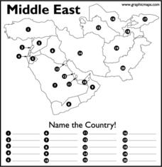
In this map of the Middle East worksheet, students study the map of the Middle East and then write the names of the 20 countries on the provided lines.


