Indian Land Tenure Foundation
Maps and Homelands
You are never too young to learn about maps. To better understand the concept of a homeland, students work together to construct a map of their local area out of paper puzzle pieces. They'll put the maps together and then add details by...
Curated OER
Lesson Design Archaeology- USGS Maps
Learners research USGS maps and identify the major features. In this map skills lesson, students identify low and high elevations on a USGS map and practice finding latitude and longitude.
Curated OER
Wales: An Interdisciplinary Unit
Young scholars practice basic map and geographic skills as they compare Oregon to Wales. Students color map of Wales and Oregon using color codes to distinguish between land, water, and bordering nations or states, listen to stories and...
Curated OER
A View from the Ground
Students look at a park from ground perspective. In this map skills lesson, students are introduced to a story about a girl at a park and make observations about the park based on a picture. This prepares students for the next lesson in...
World Maps Online
Introduction to the World Map
Students identify the differences between maps and globes. In this map skills instructional activity, students are shown a globe and a map and recognize the differences. Students use post-it notes to locate several locations on the world...
Illustrative Mathematics
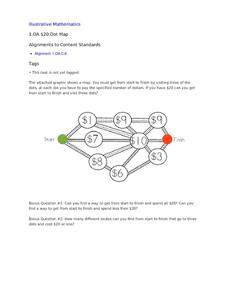
$20 Dot Map
Challenge the addition skills of young learners with this open-ended math problem. The task is simple, get from start to finish by connecting a series of three numbers. The trick is that the sum of the numbers must be less than or equal...
Newspaper Association of America
Community Connections with Geography and the Newspaper
Understanding geography and government begins at the local level. Using maps and the parts of a newspaper, a unit plan introduces the concept of community. It starts with the creation of classroom and school maps, and then moves through...
Curated OER
Hazards: First Grade Lesson Plans and Activities
Examine the environmental hazards associated with volcanoes with a three-part science lesson. In the pre-lab, first graders learn that gas, landslides, ash, and lava are all hazards that come from volcanoes. They then explore hazardous...
Curriculum Corner
Camping Literacy Pack
Increase camping vocabulary just in time for summer with a camping themed literacy pack. Use word cards and sentence cards to enhance fluency, build vocabulary, and strengthen writing skills. The activities are perfect for centers,...
Curated OER
2010 Census Lesson 1: It's About Us
Learners analyze data from the 2000 census to learn how the census works. In this civics lesson, students read a story to find out about the census, then use a map and census data to analyze changes. Lesson includes related resources...
Curated OER
Cacao Tree Geography
Learners use a map to learn about where chocolate comes from. In this lesson on the cacao tree, students locate various regions where the cacao tree grows. They will discuss why the cacao tree grows more favorably in particular climates...
Curated OER
The Globe and World Map
Students explore how to use maps for travel. In this map skills instructional activity, students read the text, With Love from Gran and discuss the places the character traveled. Students list the names of each city and country on chart...
United K12
Jan Brett Author Study
Expose young children to the wonderful works of author and illustrator Jan Brett using a few of her stories such as Armadillo Rodeo, The Mitten, or Daisy Comes Home through a unit study.
Curated OER
United States Map
Students describe cities they are familiar with. In this United States Map lesson, students understand how cities are listed on a map. Students become aware of a map legend and the information in it.
Curated OER
United States Map - Lesson 11
Students explore lakes of the United States. In this geography lesson, students identify noteworthy lakes on a map of the United States.
Curated OER
Go West With Columbus
Students play a board game where their tokens must move Columbus west. They choose cards which give commands to move in a coordinate direction. They practice moving west, north, east, south by playing the game.
Curated OER
As the Kids Come and Go: Mapping a Classroom
Map the classroom with your kids to help them understand how maps work and how to read them. The lesson starts off with a story about animals living and moving around the globe, and then kids create maps of their classroom to show how...
Curated OER
My Daily Routine
Foreign language learners work in pairs to translate the daily routine of celebrities or everyday people, presented in daily planner format, into English. They then illustrate and record their own daily routines in storyboard (film...
Curated OER
Mapping Our Home
Students explore how communities participate in census counting. In this census lesson, students recognize the absolute and relative location of a state and understand ideas about civic life and government.
Curated OER
I Can Find that Where? - A Study of Landforms
First graders make landform maps of the United States. In this landform lessons, 1st graders participate in a discussion of local landforms and make a landform map of the United States. They follow the teacher's directions to add plains,...
Curated OER
Map It Out
Explore how illustrations add to a story. Young learners will look at picture books to see how the pictures tell the story. They create illustrations to go with a chosen story, and then flip the activity so they have to write a story to...
Curated OER
Math with Maps and Globes
Students round out their math skills with these ‘round the world' ideas. In this math and geography lesson, students try out time zone sticks, a polar race, and tic-tac-globe to engage them in learning more about globes and the...
Curated OER
Through the Forest and Home Again: Maps Help Us Find Our Ways
Students read Little Red Riding Hood, focusing on her path home to Grandma's house. In this language arts and geography instructional activity, students perform a reader's theater, re-creating the walk home and possible routes that could...
Curated OER
Learning to Read a Map
First graders identify the map and globe symbols: Cardinal Directions; Compass Rose; Mountains; Rivers; Lakes; Towns; Roads.


