Curated OER
Exploring California's Regions
Students participate in small groups to create a California's Region map. They research and identify the climate, geographic features, and one or two special features of their assigned region.
Fremont Unified School District
4th Grade California Relief Map Project
Bring life to your next California geography lesson with this great project! Learners design a three-dimensional wall relief map of California, painting and decorating regions using a variety of materials and labeling major geographical...
Curated OER
Those Particular Plants in Particular Regions
Fourth graders, acting as a botanist, analyze information on different plants in different regions of California. They characterize each plant for each region and answer a variety of question for each plant while doing this study.
Curated OER
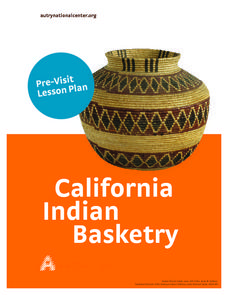
California Native American Basket Weaving
Fourth graders consider the role that baskets play in the traditional lives of Native Americans in California. Students investigate types of baskets and their various uses and then weave their own baskets.
Curated OER
Postcards from California: A Unit on Geography, Social Studies, History and California's Resources
Fourth graders examine patterns that influence population density in the various regions of California. The unit's three lessons utilize graphic organizers for the interpretation and presentation of data.
Curated OER
A Dollar Goes A Long Way
Investigate life along the Old Spanish Trail! They visit websites and identify the history and environment. They create journals, dramatic enactments, and maps to discover the role individuals played in society. They also explore the...
Curated OER
Exploring the Various Regions of Boyle Heights: Continuity and Change
Student study the local landscape of Boyle Heights, California and draw a sketch of the area. Students use map making skills in this activity. Studient make a portfolio of information and photographs they accumulate over time on the area.
Curated OER
My Summer Vacation
Students study the United States geography using Google Earth. In this U.S. geography lesson, students create travel journals about five U.S. geographical locations. Students research the human and physical characteristics for each region.
Curated OER
Geography: Intro to Canada
Students investigate the geography of Canada by analyzing a map of the country. In this North American geography lesson, students identify the 13 provinces of Canada and their locations by examining a Canadian map. Students may use...
Curated OER
Tectonic Plates, Earthquakes, and Volcanoes
Challenge geography classes to locate the major volcanoes and earthquake faults on a world map. In groups, they identify the pattern made and examine the relationship between the locations of the faults and volcanoes and tectonic plates....
Curated OER
Medieval African Kingdoms
Seventh graders examine the geography and political history of West Africa. They role-play as applicants to a company that transports customers to any historic time period. Working in teams, they create promotional products encouraging...
Curated OER
The Stolen Smell
Third graders read the story The Stolen Smell, and complete language arts activities based on the book. In this The Stolen Smell lesson plan, 3rd graders complete activities such as discussion, reading, researching, drawing, role...
Curated OER
Spanish Colonization: The Anza Expedition
Students research the Spanish explorations and North American geography. They create web pages based on their study.
Curated OER
The Legend of the Indian Paintbrush: Native American Life
Students read," The Legend of the Indian Paintbrush" by Tomie dePaola and discuss the way legends are passed down orally. They then create their own legend and illustrate it on a simulated "Buffalo Skin" made from brown paper.


