Super Teacher Worksheets
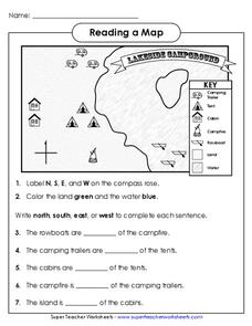
Reading a Map
Young geographers improve their map skills by practicing locating the cardinal directions on a map, identifying symbols on a map key, and describing where objects on the map are located relative to other locations.
T. Smith Publishing
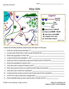
Map Skills
Help younger learners develop their map skills with this simple worksheet, which includes 12 questions utilizing a map legend that involves highway markers, population indicators, and other landmark signs.
National Geographic
Mapping the Americas
Celebrate the geography of the Americas and develop map skills through a series of activities focused on the Western Hemisphere. Learners study everything from earthquakes and volcanoes of the Americas and the relationship...
Richmond Community Schools
Map Skills
Young geographers will need to use a variety of map skills to complete the tasks required on this worksheet. Examples of activities include using references to label a map of Mexico, identify Canadian territories and European...
Curated OER
John Smith’s Map of the Chesapeake Bay
Young geographers travel back through time with primary source and map analysis and envision Captain John Smith's arrival at the Chesapeake Bay.
Luminations Media Group
Geography: Map Reading Basic Skills
Enhance scholars' map skills using this worksheet displaying the land of Kahitsa’an from the series, The Realm, by K.L. Glanville. The activity helps readers visualize the make believe-land, examine its attributes, and answer...
NASA
Outline Maps
Don't miss this gold mine of blank maps for your next geography lesson! Regions include traditional continents such as Asia, Europe, and Africa, as well as other major world areas such as the Pacific Rim and the Middle East.
Tennessee State Museum
An Emancipation Proclamation Map Lesson
Did the Emancipation Proclamation free all slaves during the Civil War? Why was it written, and what were its immediate and long-term effects? After reading primary source materials, constructing political maps representing information...
Public Schools of North Carolina
Democratic Republic of Congo - Map Skills
Work on your map skills with a packet of activities about the river basins in the Democratic Republic on Congo. Learners study the maps provided before answering the geography questions and writing an acrostic poem about the region.
Royal Geographical Society
An Introduction to Maps
First graders are introduced to a variety of maps such as globes, street maps, atlases, and different types of floor plans. The focus of the lesson requires individuals to create their own plan of the classroom using the PowerPoint...
Austin Independent School District
History Mapping
This is a great activity to have on hand to help your young historians summarize major historical events. Learners identify key players and contextual information, major episodes of the event, and any resolutions or lasting...
Institute for Geophysics
Understanding Maps of Earth
Here is your go-to student resource on primary geography concepts, including facts about the surface of the earth and its hemispheres, latitude and longitude, globes, types of maps, and identifying continents and oceans.
KOG Ranger Program
Fire Behavior in Forests
Understanding the ways a fire will act is a key factor in fire safety and fire prevention. Young campers focus on how the weather and terrain can affect the behavior of a fire with topographic maps and different...
Scholastic
Volleyball Road Trip
Review coordinate mapping with your young geographers by matching cities on a volleyball team's road trip itinerary to their appropriate coordinate locations.
Mathematics Vision Project
Module 7: Connecting Algebra and Geometry
The coordinate plane links key geometry and algebra concepts in this approachable but rigorous unit. The class starts by developing the distance formula from the Pythagorean Theorem, then moves to applications of slope. Activities...
EngageNY
How Do Dilations Map Angles?
The key to understanding is making connections. Scholars explore angle dilations using properties of parallel lines. At completion, pupils prove that angles of a dilation preserve their original measure.
Student Handouts
Geography of Dr. Martin Luther King, Jr.
Young geographers follow Dr. Martin Luther King's journey during the civil rights movement by identifying major events on a map of the eastern United States, such as his birth in Atlanta, Georgia and his famous...
Curated OER
Introduction to Age of Absolutism
Who were the absolute monarchs of Europe and what effect did they have on their countries? Young historians begin by naming qualities they believe are important for a monarch to possess. They then take notes on four key factors...
EngageNY
Reading Closely to Expand Understanding of Adaptations
Third graders work to determine the main idea, recall key details, and answer questions using an informational text on the topic of animal adaptations. Using the non-fiction text "Staying Alive: Animal Adaptations" (provided) the teacher...
Super Teacher Worksheets
United States of America
Here is the perfect assessment to test your young learners on labeling the 50 states! Each state is given a number on a blank map of the United States, and a second page lists the numbers in order for learners to identify.
Mathematics Assessment Project
Representing Quadratic Functions Graphically
Sometimes being different is an advantage. An engaging activity has scholars match cards with quadratic functions in various forms. Along the way, they learn about how each form highlights key features of quadratic functions.
Curated OER
Learn the States and Postal Abbreviations
If you are preparing to cover the 50 states with your class, you don't want to miss this resource. It includes an excellent set of worksheets through which learners practice identifying states from their abbreviations and placing those...
Geography 360°
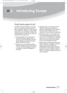
Introducing Europe
Provide your learners with a comprehensive introduction to Europe with this great set of worksheets. Map activities include matching European countries to their capitals and places on a political map, as well as...
National Research Center for Career and Technical Education
Transportation, Distribution, and Logistics: Tire and Wheel Assemblies
Is bigger really better? By the end of this lesson, learners will be able to apply formulas for computing the diameter of tires and wheel assemblies. Begin by showing a slide presentation that will review definitions for radius and...
Other popular searches
- Map Key and Legend
- Map Legends
- Map Key Legend
- Map Keys and Legends
- Map Key Legend Activities
- Map Legends and Symbols
- Map Legends First Grade
- Interpreting Map Legends
- Reading Map Legends
- Creating Map Legends
- Using Map Legends
- Semantic Map Legends


