Curated OER
Fourth Grade Social Studies
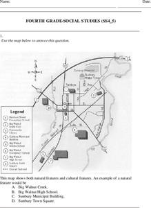
In this social studies worksheet, 4th graders answer multiple choice questions on state maps, city maps, road maps, political maps, and more. Students complete 25 multiple choice questions.
Curated OER
New York City Map
For this New York city map worksheet, students examine the city. The map highlights some of the points of interest in the city.
University of Texas at Austin
University of Texas: Perry Castaneda Library: Canada Maps
The University of Texas at Austin provides an extensive collection of maps relating to Canada. Links are given for maps of Canada on many other web sites.
University of Texas at Austin
University of Texas: Perry Castaneda Library: Colorado Maps
Features a vast collection of a variety of different maps all representing the state of Colorado. View state maps, city maps, historical maps, National Park maps, and more.
University of Texas at Austin
Perry Castaneda Library Map Collection: Tennessee Maps
A listing of online historical and current maps for the State of Tennessee. Part of the Perry-Castaneda Library Map Collection.
Library of Congress
Loc: Maps of Cities and Towns
Looking for old maps of somewhere in the United States? Check out this huge collection of maps! Search by the name of a city or town, another keyword, subject, title, or geographic location.
National Endowment for the Humanities
Neh: Edsit Ement: Mapping Our Worlds
In this lesson, introduce your young scholars to the world of maps and discover a world of information online. Students learn how to identify different types of maps, comparing maps to the rooms of a house.
abcteach
Abcteach: Maps
[Free Registration/Login Required] Find outline maps of the continents and the United States and Canada, as well as other country and city maps.
Can Teach
Can Teach: Creating an Edible Map
This imaginative lesson uses food products to demonstrate the physical characteristics of maps.
Yale University
The Yale Map Collection: Online Maps
Yale University provides us with one of the largest collection of maps in the United States. Here you can view historical online maps covering a variety of subjects.
University of Chicago
University of Chicago Press: What Is a Map? A Collection of Unusual Maps
Showcases a collection of unusual maps from the book "Maps: Finding Our Place in the World." Types of maps included are journey maps, city maps, slave maps, imaginary maps, and handy maps.


