Curated OER
Visualizing and Naming Polygons
A really useful resource contains 116 slides covering basic geometric concepts related to 2-D or plane shapes. Shape properties, translations, reflections, congruence, symmetry, and grid work are all laid out in a comprehensive and...
Houghton Mifflin Harcourt
Four-Quadrant Grid
Give your graphers a complete grid to neatly organize their coordinates and lines without having to draw one on their own. This four-quadrant grid provides labeled markers for each line up to -10 and +10 in all directions.
Curated OER
Shapes on a grid #1
Before learning about the coordinate plane and ordered pairs, have kids get used finding locations on the grid. They are given a simple set of coordinates, which they will locate on the grid. A great way to introduce the concept.
Curated OER
Planning a Garden Using a Grid
Third graders plan for a garden. In this garden planning lesson, 3rd graders investigate the use of a grid to accurately map out and plan for a vegetable garden. Students predict the space requirements for different vegetables.
Curated OER
Location on a Grid
There are 12 symbols on this large grid, and scholars must record a location for each. They use the coordinate pair system which is made easier because every symbol is directly inside a square. Use this to introduce coordinate pair...
Curated OER
Location on a Grid
Make coordinate pairs more engaging by having beginners color-code a grid based on given locations. The grid has numbers along the y-axis and letters along the x-axis, introducing them to the ordering of coordinate pairs with the x-axis...
Curated OER
Number Pairs
As you introduce graphs and coordinate pairs, use this guided activity to get scholars started. They reference an example before recording number pairs to identify the location of 12 letters on a grid. Next, learners examine shapes on a...
Curated OER
Location on a Grid
This grid features 15 animals, and scholars use a coordinate system to describe the location of each. The x-axis is labelled with letters and the y-axis with numbers, and they list the coordinate pairs beside the animal names below the...
Curated OER
Number Pairs
What's the coordinate pair? There are 16 letters located on this grid, each marked by a point. Learners record the number pair for each. All of the coordinates are whole numbers. Consider extending this in a fun way by challenging pupils...
Curated OER
Number Pairs
This engaging coordinate pairs activity will have scholars intrigued; they mark 13 points on a grid and then connect them to create a capital block letter. Which one will it be? The grid has whole numbers 0-10 along both axes, so...
Curated OER
Location on a Grid
Locating a point on a grid is an important skill to master; use this practice sheet to give schlars some clear and useful experience. On a large, simple grid they use a coordinate system to find specific squares and color them a given...
Utah Education Network (UEN)
The Pasture and the Fence
Beginning geometers use tiles and grid paper to draw and calculate perimeter and area. Rectangles of different sizes are created and then measured to build understanding. The one-inch grid sheet referenced is attached.
Curated OER
Easter Graphing Fun
Graphing can be festive! This Easter worksheet has scholars using coordinates to record the location of ten holiday images. The first is done for them, and the grid is large and appealing to younger learners. Consider visualizing this...
Mathwire
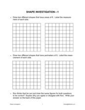
Shape Investigation: Area and Perimeter
Does a shape's perimeter always match its area? Learners approach this and other claims in this shape investigation worksheet. Using blank grids, they draw various shapes based on required perimeter and area measurements, labelling the...
Curated OER
Pattern Block Barrier Game
Challenge your learners to give clear and concise directions in this shape-name practice activity. In partners, they place a dividing "wall" between them, with pattern blocks and a grid on each side. Partner A places one block at a time...
Curated OER
Scale Drawings of Birds
Students create their own copies of Phoenix Birds using a grid system.
Curated OER
Decimal Models
Before jumping into numeral decimals, explore them visually using this base 10 strategy. There is a set of examples to help scholars understand the concept. They color in grids to represent decimals written in a variety of ways. Some...
Curated OER
Rise Over Run
In this rise over run worksheet, students solve and complete 2 different problems that include determining the rise over run for a race ran. First, they use the information in the table to graph each person's performance using a...
Curated OER
The Greeley, Colorado Problem
In this Greeley, Colorado problem, students read a word problem. They use given directions and a coordinate plane to determine the number of ways to satisfy given travel conditions. This one-page worksheet contains 1...
Curated OER
Measurement
In this measurement worksheet, 7th graders solve 14 various types of problems that include completing a table with the base, height, and/or area of triangles and solving a number of word problems with measurement. They also estimate the...
Curated OER
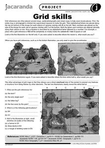
Grid Skills
In this geography activity, students use grid references on a map to locate places in the pictures given. They also identify another advantage of using a grid map, which they have an overhead view of the content to prevent any features...
Curated OER
School Sleuths Treasure Map
Students are explained how a grid and compass work. They are also explained that archaeologists use grids as a record of the exact location of artifacts. Students define the term datum as a point of reference on grids from which all...
Curated OER
Blackout!
Students read news reports and first-person accounts of a blackout in a large city and keep weblogs or journals. They take on different roles of people who live in the city or commute there to work and then use their journal accounts to...
Curated OER
Map It Out
Third graders create obstacle course maps. They lay out their course on the playground, using symbols for trees, fences, etc, Students, in groups, exchange maps and then follow the courses.


