Curated OER
Scaling it Down: Caves Have Maps, Too
Measurement and map skills are the focus of this lesson, where students crawl through a "cave" made out of boxes, desks and chairs, observing the dimensions. Your young geographers measure various aspects of the cave and practice...
Education World
Edible Resource Maps!
Young scholars discuss resource maps and examine examples from library resources. Working in groups, they create edible resource maps by drawing examples, such as popcorn on the border of Iowa and Nebraska. Then they use cookies in the...
Education World
The African American Population in US History
How has the African American population changed over the years? Learners use charts, statistical data, and maps to see how populations in African American communities have changed since the 1860s. Activity modifications are included to...
Curated OER
Map Skills
Thirds graders reinforce that a map is a drawing that shows what a place looks like from above. They use a map key and symbols to create a map of the school and its neighborhood.
Curated OER
Mapping My World
First graders make two maps. In this developing and reading maps lesson, 1st graders read Mapping Penny's World, discuss the parts of a map, create a map of their classroom, and create a list of directions of how to get to various...
Curated OER
Mapping the News
Students explore cartography. In this map skills and map making lesson plan, Students work in groups to create wall size world maps including legends, compass roses, latitude and longitude, and physical features. Students...
Curated OER
Understanding: Geography
Students explore their neighborhoods. In this geography lesson plan, students make a map of their neighborhood. They must include a key, natural terrain, buildings and streets. They also write a descriptive paragraph about their...
Curated OER
Map Making
In this map making worksheet, students draw a map of their home including a map key. In this drawing worksheet, students create one map.
Curated OER
Topographic Mapping Skills
In this geography worksheet, learners read an excerpt about topographic maps and why they are useful for various jobs. They also respond to eleven questions that follow related to the excerpt and locating specific map points on the map...
Curated OER
Create a Country
Learners work in small groups to list features and elements found on a variety of grade- appropriate maps. They develop a class list of map features and elements to draw from as they create a map of an imaginary country.
Curated OER
U.S. Geography- The Northeast
Students investigate the geography of the Northeast states. In this map skills lesson, students are shown a map of the Northeast states and identify the state names and borders. Students construct individual maps of the Northeast using...
Curated OER
Lesson Design Archaeology- World Map
Students practice locating positions on the world map. In this map skills lesson, students explore the world map and items such as the compass rose, Equator, mountains, cities, etc. The students practice locating positions on the world...
Curated OER
Mapmaker, Make Me a Map!
Pupils are introduced to the state quarter program and examine the Colorado state quarter. They locate Colorado on a map and create a map with a key. They discuss the state motto and examine pictures of the state's geographical features.
Curated OER
Map Literacy
Students locate their home state on a map. They differentiate between physical and population sizes of states. In two groups, students "become" states with string for boundaries. They ascertain that area does not always equal large...
Curated OER
Mapmaking: Colorado Quarter Reverse
Students examine the Colorado quarter reverse and draw symbols of the state's land and water features on maps. Using copies of the Colorado reverse, they color the coin design. They list reasons for the state's motto of "Colorful Colorado"
Curated OER
Quarters from the Coast
Students examine the Maine state quarter and discuss the features on the quarter that identify Maine as a coastal state. They identify coastal states and inland states on a map.
US Geological Survey
Usgs: Geologic Maps
This site has a good description of what this particular type of map represents. It also explains the colors and letter symbols, faults, and strike and dips.
Read Works
Read Works: Learn About Maps
[Free Registration/Login Required] Intended to support early elementary students' reading comprehension, the basic terminology associated with map are explained in this informational text. A question sheet is available to help students...
Success Link
Success Link: Bug Explorers for Columbus Day
A fun lesson plan using the voyages of Columbus as a jumping off point to introduce maps and what can be learned from them. Covers content standards for geographic study and evaluating nonfiction works.
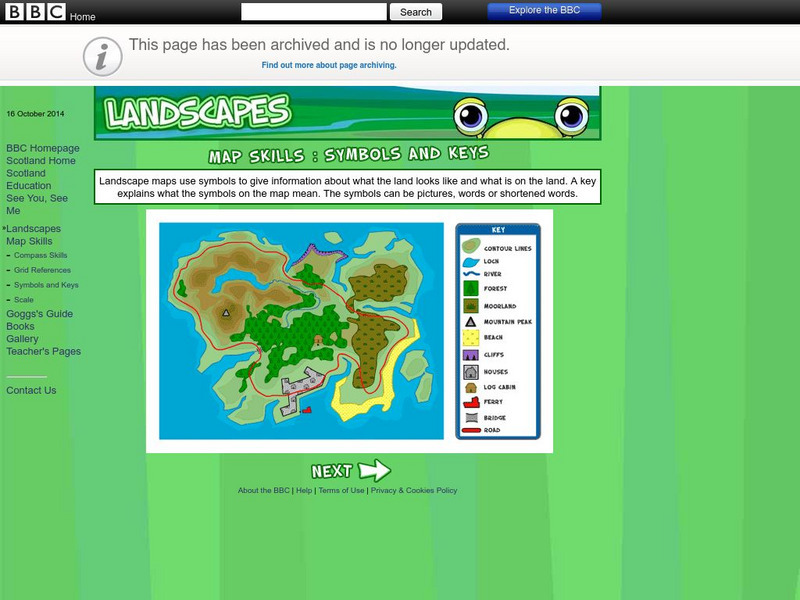
BBC
Bbc: Landscapes: Map Skills: Symbols and Keys
A guide for young learners to understand reading maps and their keys.
Science Education Resource Center at Carleton College
Serc: Mn Step: Student Created Landform Maps With Glacial Emphasis
An activity where young scholars work together to make topographic maps of a local park. The map must include a key and the grid locations of landforms in the park.
ClassFlow
Class Flow: Parts of a Map
[Free Registration/Login Required] This flipchart explores the basic parts of a map including the map title, compass rose and map legend.
ClassFlow
Class Flow: Maps and Globes
[Free Registration/Login Required] This flipchart reviews map and globe features. The seven continents, four oceans, and city-county-state-country relationships are also explained. Student assessment on directions is included.
ClassFlow
Class Flow: Introduction to Maps
[Free Registration/Login Required] Students are expected to: explain the purpose of a map; identify and use a compass rose; use a grid to locate objects on maps; and use a map key. Activities are hands-on with students manipulating...


