University of Texas at Austin
University of Texas: Kuwait
In this Perry-Castaneda Collection of maps of Kuwait you can find political maps, relief maps and a series of maps showing Iraqi positions and U.S. positions during Desert Storm in 1991.
University of Texas at Austin
Perry Castaneda Library Map Collection: Tennessee Maps
A listing of online historical and current maps for the State of Tennessee. Part of the Perry-Castaneda Library Map Collection.
University of Texas at Austin
University of Texas: Saudi Arabia
Check out this collection of maps of Saudi Arabia from the Perry-Castaneda Collection. You can find political maps, relief maps, and historical maps of the area.
University of Texas at Austin
Perry Castaneda Library Map Collection: Venezuela Maps
This site provides several country and city maps as they relate to Venezuela.
University of Texas at Austin
Perry Castaneda Library Map Collection: Maps of Bangladesh
The Perry-Castaneda Library at the University of Texas provides an outstanding collection of maps of the country of Bangladesh. PDFs (require Adobe Reader).
University of Texas at Austin
U. Of Texas: Yemen Maps
A collection of maps of Yemen from the Perry-Castaneda Collection offering political maps, historical maps, relief maps, and thematic maps.
University of Texas at Austin
University of Texas: Armenia Relief Map
This relief map of Armenia from the Perry-Castaneda collection shows how mountainous this Caucasus country is. It also demarcates the provinces and traces the rivers.
Japanese Ministry of Foreign Affairs
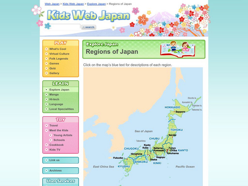
Web Japan: Regions of Japan
Here is a map showing the nine regions of Japan followed by a brief discussion of the regions and their cultures.
US Geological Survey
U.s. Geological Survey: The Usgs and Science Education
"Explore things on, in, around and about the earth," with this web site dedicated to K-12 education from the United States Geological Survey. Homework help, science topics and fun learning games for students in Kindergarten through High...
Annenberg Foundation
Annenberg Learner: Bridging World History: Maps, Time, and World History
Learn how map projections and chronological constructs are used in the study of world history and help us to understand and interpret the past. Part of a larger site on world history, this unit on maps offers complete reading,...
Annenberg Foundation
Annenberg Learner: Journey North: Judy Brophy: The World's Biggest Address Book
Great slideshow to learn about latitude and longitude. There are many great discussion questions as well as maps to enhance your learning.
The Newberry Library
Newberry Library: Historic Maps in K 12 Classrooms
Great resource for teachers of geography and American history for all levels. You will find lesson plans based on the use of maps for all ages.
Other
Climate Change Institute: Climate Reanalyzer
Using interfaces for reanalysis and historical station data, the Climate Reanalyzer provides an intuitive platform for visualizing a variety of weather and climate data sets and models.
Library of Congress
Loc: Map Collections 1500 2002
This collection provides maps dating back to 1500 up to the present. The collection includes: cities, towns, discovery and exploration, conservation and environment, military battles, cultural landscapes, transportation, communication,...
Other
State University of New York at Stony Brook: New York State Historical Maps
Historical maps of New York and descriptions of each map.
Other
Metro De Madrid Maps
Detailed downloadable subway maps for Madrid, Spain highlighting significant places around the city. A great way to practice, in Spanish, using a subway map to get around in Madrid to see the sights.
Other
American Meteorological Society: Data Streme Atmosphere
This site provides an extensive amount of weather information. Includes current information, forecasting, and historic weather related events. Weather map symbols and terminology explained.
University of California
World History for Us All: Getting Our Bearings: Maps of Time, Space, and History
Understanding history requires students to be able to see the big picture. This teaching unit introduces students to tools they can use to investigate history. Topics covered include cartography, chronography, and maps of space, time and...
The Newberry Library
Newberry: Exploration and Encounter: Map 2: Indian Map of the Southeast, 1721
K-12 lessons using historical maps from Newberry Library presents an Indian map of the Southeast, ca. 1721. Learners use maps to understand how spatial relationships are represented. Links to supplemental resources and reference material.
National Geographic
National Geographic: Places in the Park
Modeling the use of maps in and out of school can help students to recognize the value of maps and gain confidence with them. Using maps of places that are familiar to students will strengthen their spatial thinking skills before...
National Geographic
National Geographic: Mapping the Classroom
Learning to use and create maps builds students' spatial thinking skills as well as language skills in the early years. For this lesson, students practice using the language of location and then apply that language when creating a map of...
Utah Education Network
Uen: The Pony Express
Fourth graders will draw a map showing the route they travel from home to school.
National Geographic
National Geographic: Mapping
Media-rich resource features extensive mapping tools including activities, games, reference, printables, and more.
Princeton University
Princeton University: Qed: Mapping Globalization: Map Category Queries
A large database of historical maps that can be searched by map type, time period (prehistory to 21st century), theme, and world location. Themes cover economics, war, disease, trade, migration, and much more.


