Curated OER
Map Maker Map Maker
Students create their own maps. In this map making lesson, students go to Microsoft Word and create a chart. They label directions, buildings, streets, and distance.
Curated OER
Fourth Grade Social Studies
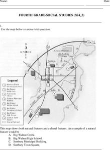
For this social studies worksheet, 4th graders answer multiple choice questions on state maps, city maps, road maps, political maps, and more. Students complete 25 multiple choice questions.
Agriculture in the Classroom
A Holiday Tradition: Which Christmas Tree Will You Choose?
Different varieties of Christmas trees provide an interesting way to combine social studies, science, math, and technology. Class members not only research the history of the Christmas tree holiday tradition, they compare and...
Curated OER
Learn the States and Postal Abbreviations
If you are preparing to cover the 50 states with your class, you don't want to miss this resource. It includes an excellent set of worksheets through which learners practice identifying states from their abbreviations and placing those...
Curated OER
Weather Map Challenge
In this weather worksheet, students use a weather map to answer ten questions about the information found on a weather map and what the symbols mean. They find the cities with the highest and lowest temperature as well as the cities...
Curated OER
The Places We Will Go
Second graders demonstrate basic map skills. They each bury a bag of chocolate coins, create a map with directions to find their "treasure," and follow another student's directions to locate a bag of coins.
Curated OER
Extreme Weather and Mapping
For this environment worksheet, students read an article about extreme weather conditions and mapping it out. They respond to 10 multiple choice questions about what they read. Then, students explain how droughts can occur and the...
Curated OER
Mapping My World
Students are introduced to simple maps and view a map of a classroom and compare distances of items shown.
Curated OER
GIS Mapping: Special Instructions for Using Digital Orthophotos
Students practice cartography using GIS technology. They create a map of Austin using GIS and aerial photos.
Science Matters
A Model of Plate Faults
The San Andreas fault is one of the longest fault zones in the world. In a series of 20 lessons, the fourth lesson has pupils use a paper model to recreate various types of plate faults. Each is held in position then drawn...
Notion
Popplet
Add color to the mind-mapping process! Users double tap to create a bubble and everything flows quickly from there as they drag, draw, type, and more.
EngageNY
The Inverse Relationship Between Logarithmic and Exponential Functions
Introducing inverse functions! The 20th installment of a 35-part lesson encourages scholars to learn the definition of inverse functions and how to find them. The lesson considers all types of functions, not just exponential and...
National Nanotechnology Infrastructure Network
What’s In Your Neighborhood?
Chart your way to an understanding of nanoscale. Using a Google map, learners estimate a radius around their location of 1,000 and 1,000,000 meters. Predicting what 1,000,000,000 meters would look like takes them off the charts!...
Gymnázium Karviná
Australia and New Zealand
Send your learners off on a research adventure with a worksheet on essential facts about Australia and New Zealand. It includes 18 short-answer response questions, as well as a map activity where pupils locate a variety of...
National Park Service
Petrified Forest National Park
Poetry Soup, a reading and writing unit constructed by the Petrified Forest National Park, will have scholars hungry to learn about nature. The cross-content unit contains topics related to history, science, and language arts. Content...
NOAA
Thunderstorms, Tornadoes, Lightning. . . Nature's Most Violent Storms
Thunderstorms, tornadoes, floods, and hail are just a few of the topics covered in a thorough weather preparedness guide. With descriptions of each weather phenomenon, from what causes them to how and when they occur to...
Curated OER
When You're Hot, You're Not!!
Middle schoolers investigate volcanoes. In this landforms activity, students locate two volcanoes on a world map. Middle schoolers compare and contrast the types of volcanoes by using various Internet sites.
Curated OER
Study Skills Assignment
Students utilize six different types of study skills as they review material for a final exam. They are graded on the exam and on the study process for the exam.
Curated OER
Weather Forecasting Unit
Young scholars study weather concepts, mapping, characteristics in this series of lessons.
Curated OER
Europe Map Quiz
For this online interactive geography quiz worksheet, students respond to 45 identification questions about the countries located in Europe. Students have 5 minutes to complete the quiz.
Curated OER
Pictures of Data
In this data worksheet, students look at maps and charts and answer multiple choice questions about them. Students complete 10 questions.
Curated OER
Arthur's Tooth
Young scholars practice their reading comprehension by reading a story in their class. In this story map lesson, students read the Marc Brown book Arthur's Tooth and discuss the story, characters and setting. Young scholars create a...
Curated OER
Mapping Teeth
Students identify the arrangement of their teeth. In this dental anatomy instructional activity, students discuss the functions of each type of tooth and record the state of health of their teeth on a chart. Students brainstorm ways they...
Curated OER
Let's Take a Trip!
Sixth graders plan trip for family of four, and choose best travel plan by studying maps, considering different routes, and visiting Web sites to get airline and travel schedules.


