Curated OER
Learning European Geography
Sixth graders discover locations and countries in Europe by identifying them on a map. In this European geography activity, 6th graders read the book The Lost Little Elephant, with their class and discuss the geography referenced in the...
Curated OER
GNP Simulation Using Foods in the Americas
Students explore food supply distribution. In this GNP distribution lesson, students participate in a simulation that requires them to eat foods from the American continents. Students are served according to their chance positions in...
Curated OER
Animals of Australia Word Search
In this animals word search puzzle, students analyze 25 names of Australian animals and locate them in a word search puzzle. There is a graphic of the Australian continent.
Curated OER
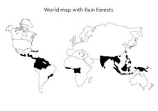
World Map With Rain Forests
In this geography worksheet, students study a map of the world which shows shaded areas indicating where the rain forests are located. There are no labels for countries or continents.
National Wildlife Federation
I’ve Got the POWER Wind Energy Potential at Your School
The 20th instructional activity in a 21-part series connects the wind data and expectations of a turbine to whether such devices should be built in your area. Scholars begin with estimating the wind potential at school by using long-term...
Curated OER
Drifting Continents, Dynamic Results
Students plot earthquake and volcano data using a Compass Rose Plotting. They explain the relationship between plate movement and connection. They draw conclusions that earthquakes and volcanoes occur in predictable locations.
Curated OER
Continental Drift
Students simulate convection waves using a model. In this earth science lesson, students explain the effect of plate movements to Earth's geography. They use the internet to find answers to graphic organizer questions.
Curated OER
History/Geography
Students review North America, Africa, Europe and Asia. They identify Australia as the smallest continent. They identify Australia as an island continent nicknamed "the land down under." They color a map of Australia.
Curated OER
Discovery Atlantis
Students explore Atlantis. In this geography lesson, students research selected websites to discover information about the lost continent of Atlantis. Students use the fruits of their research to participate in a debate regarding the...
Curated OER
PLATE MOVEMENTS AND CLIMATE CHANGE
Pupils label three geological maps with continents provided to analyze the relationships between the movement of tectonic plates and the changes in the climate. In small groups, they discuss their findings and form hypotheses about the...
Curated OER
A World of Favorites
Investigate young scholars' favorites worldwide by having them create and publish a questionnaire to gather information about students' favorites. They will conduct research about a continent, create three web pages and a chart...
Curated OER
Introduction to Africa
Students are introduced to Africa. The purpose of this lesson is to find out what students all ready know about the continent of Africa, and what students are interested in learning more about. They focus on the physical features of Africa.
Curated OER
Me on the Map Lesson 1
Students use maps, globes, geographic information systems and other
sources of information to analyze the nature of places at a variety of scales. They identify on a map and determine the population
of the city, county, state, country...
Curated OER
World Map and Globe - Lesson 15 Mountains of the World
Students locate major world mountain ranges. For this geography lesson, students identify major mountain ranges on 6 on of the 7 continents on a large world physical map.
Curated OER
How Can We Organize Study of a Given Place?
Seventh graders embark in discovery of basic facts about an assigned continent and are asked to organize their information into categories. The Five Themes model is taught and students reshuffle their information appropriately.
Curated OER
Getting to Know My World
Students participate in hands-on activities using maps and globes to identify geographical features. Students use map legends to identify direction. Students locate oceans, continents, countries, states and cities. Handouts and...
Curated OER
Thematic Unit on Cats
Students discover in which climates the cats of the world live in. They review the different climates of the world and use maps and globes to help them locate continents.
Curated OER
Ecology And the Conservation of Natural Resources
Students study Alfred Wegener's theory of continental drift and how the continents were connected in one large land mass called Pangaea. They examine plate tectonics and the theory that the earth's surface is composed of large moving...
Curated OER
Antarctica
Third graders become familiar with Antarctica, the Earth's southernmost continent, by researching its environment and inhabitants. They reference maps, conduct Internet research, identify animals, create graphs and write reports.
Curated OER
Foods and Languages of the World
Students celebrate diversity. In this multicultural appreciation lesson, students celebrate diversity by sampling food from different cultures, learning a few words in Spanish and identifying the seven different continents.
Curated OER
Mapping China
Young scholars identify cities in China on a map. In this map skills lesson, students locate the continent of Asia and the country of China. Young scholars use a blank map to label China and bordering countries.
Curated OER
Lesson Plan on Making a World History Timeline
Fifth graders examine and discuss the concept of chronological order. They research an assigned continent and construct a chronological timeline using a list of historic events.
Curated OER
European Explorers of North and South America
Sixth graders explore the connection between the geography of America and the migration of the Native Americans to the American continents to the future conquering of the continents by the Europeans. They discuss the causes and effects...
Curated OER
Where in the World is Egypt?
For this geography worksheet, students investigate the location of the continent of Africa and the country of Egypt by studying a map of the region. Students color the map and locate Egypt.
Other popular searches
- Continents and Oceans
- 7 Continents
- Continents Oceans
- The Seven Continents
- Learning 7 Continents
- Map Skills, Continents
- Continents and Countries
- Acronym for Continents
- Social Studies Continents
- 7 Continents and Oceans
- Blank Map Seven Continents
- Seven Continents Worksheet


