Curated OER
Lesson: Snake Handling
Are the studies of art and archeology connected? You bet they are! Young scholars research the ancient temples of Mexico by visiting an archaeology site. They describe the various temples they see, taking note of shapes, stairs, details,...
Curated OER
Lesson Plan: Carving Through History
Peek into the art and history of ancient Mexico by analyzing the artifact Stone Serpent Heads. Learners examine images of the piece, discuss its origin, history, and significance. They experience the carving process by creating similar...
Curated OER
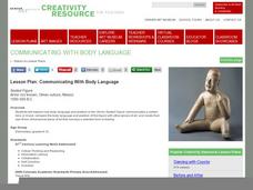
Lesson Plan: Communicating With Body Language
The Olmec were an ancient people native to Mexico who lived from 1000-500 BC. Young artists examine the Olmec piece Seated Figure to analyze the use of body language to communicate a tone or feeling. They then use clay or play-dough to...
Curated OER
Mexico's Day of the Dead
Students explore global culture by researching a Mexican holiday. In this Day of the Dead lesson, students read assigned text which discusses the view of death in several different cultures including the U.S. and Mexico. Students write a...
Curated OER
"Mexico" Lessons
Students complete a number of lessons to learn the history of Mexico. They research Aztec myths, Tenochtitlan, and create reports to share with the class.
Curated OER
Mexico: Political Map
In this Mexico political map activity, students examine state boundaries. The map also highlights major cities in Mexico.
Curated OER
Mexico Map
In this blank outline map learning exercise, students study the political boundaries of the North American country of Mexico. This map may be used in a variety of classroom activities.
Curated OER
Mexico and Central America Map
In this outline map worksheet, students study the political boundaries of Mexico and the Central American countries. This map is labeled with the country names.
Curated OER
Celebrate Independence Days Around the World
Discover how other countries remember their fight for independence and how their celebrations compare to typical American-style revelries
Curated OER
Mexico: Introduction to History and Literature
Young scholars study the geography of Mexico (i.e. major cities, surrounding countries and bodies of water, mountain ranges, rivers, volcanoes), They take turns reading aloud information provided (xerox copies) about Mexico. After each...
Curated OER
Exploring Mexico
Sixth graders describe images of a characteristic of a cultural group from 4 different time periods of Mexico's history analyzing how it has changed and why the student thinks it changed. They describe maps on 4 different time periods in...
Curated OER
Border to Border
Students use the Internet to gather information on the country of Mexico. They also discover the culture of their people and compare them with the United States population. They take a virtual tour of some of Mexico's most historical ruins.
Curated OER
What's the Connection?
Students explain hardground communities in the Gulf of Mexico. In this deep-sea ecosystem lesson, students investigate the connection between deep-sea ecosystems and petroleum deposits. They discuss the relationship between hydrocarbon...
Curated OER
Border Poetry/Writing Workshop
Learners analyze a poem set in the U.S.-Mexico borderlands and defend their own interpretations of the work. They demonstrate understanding of poetic technique by writing their own poems of living on the border.
Curated OER
Al Otro Lado
Learners view a video about the border between the United States and Mexico. They discuss the forces that influence human migration. They write a paper from the point of view of the main character in the film.
Curated OER
Everybody Celebrates
Examine the holidays of La Posada in Mexico, Hanukkah in Israel, and Kwanzaa in the United States. Learners identify the countries on a world map, listen to stories, create art projects for each holiday, and make recipes celebrating the...
Curated OER
The Huexotzinco Codex
Learners will analyze a set of pictograph documents created by native peoples of Puebla, Mexico in 1531. In this historical inquiry lesson, students take on the role of historians and study the documents. Learners construct a scenario to...
Richmond Community Schools
Map Skills
Young geographers will need to use a variety of map skills to complete the tasks required on this worksheet. Examples of activities include using references to label a map of Mexico, identify Canadian territories and European countries,...
NOAA
Biological Oceanographic Investigations – Signals from the Deep
The Deepwater Horizon oil spill directly impacted an area of the Gulf of Mexico the size of Oklahoma. A marine biology lesson looks at the impact of an oil spill on the deeper parts of the ocean. Scholars download actual data collected...
NOAA
Biological Oceanographic Investigations – Keep Away
As of 2015, there are 53,481 oil wells in the Gulf of Mexico. Scholars determine how species diversity is impacted based on the ecosystem's distance from a drilling platform. It focuses on finding the mean of data sets and creating bar...
American Museum of Natural History
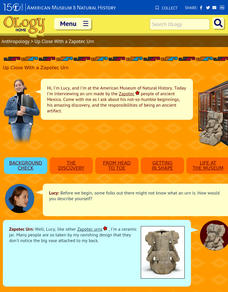
Up Close With a Zapotec Urn
If a Zapotec urn, buried for over a thousand years in a temple in the lost city of Xoxocotlan in the Valley of Oaxaca in the mountains of southern Mexico could talk image the stories it could tell. That's the set up in a clever resource...
Curated OER
Mexico: Political Map
For this Mexico political map worksheet, students examine state boundaries. The map also highlights major cities in Mexico. This map is unlabeled.
American Museum of Natural History
Being an Archeologist: Chuck Spencer
Meet Chuck Spencer, an archeologist who studies the Zapotec people who lived in the Valley of Oaxaca, Mexico over 2000 years ago. Spencer shares in print his response to questions posed by kids.
Curated OER
New Mexico
In this geography worksheet, students will be searching for words that are all cities in New Mexico. Students will locate 44 locations within the state.
Other popular searches
- Mexico Geography
- Mexican History Mexico
- New Mexico
- Christmas in Mexico
- Christmas Traditions Mexico
- Mexico Culture
- History of Mexico
- New Mexico Geography
- Mexico Immigration
- Mexico City
- Geography of Mexico
- Animals of Mexico


