University of Maryland
University of Maryland: The Ancient Dynasties
A discussion of the Shang and Zhou Dynasties of Ancient China. Includes maps and information about ancient rulers.
Other
Ancient Mysteries: Gobi Desert Mysteries
This site details information about the mysteries of the Gobi Desert, an area actually comprised more of mountains than desert. This site has a map of the Gobi area, photos of the Gobi, as well as links to information about ancient...
Other
British Museum: Imperial China
Visual and textual resources about imperial China, including chronology, primary sources, and maps.
The British Museum
The British Museum: China: Geography
Explore the geography of China and its landforms with an interactive map and game for students to play. Find out more about the importance of the Yellow River in an ancient Chinese myth.
CNN
Cnn: Visions of China
CNN offers great links to information about China. Student can click on the Imperial icon to access information about ancient China: timelines, dynasties, maps, archaeological treasures and inventions.
World Atlas
World Atlas: China
Provides an overview of China with emphasis on history. Click on any of the tabs above the maps to learn about its geography, flags. symbols, and more.
Other
The Silk Road Yesterday and Today: Map Assignment
Assignment from virtual learning module in which students label a map of the Silk Road route with physical features, then take a virtual tour to research goods, artifacts and ideas traded along the way. Students also complete a graphic...
Other
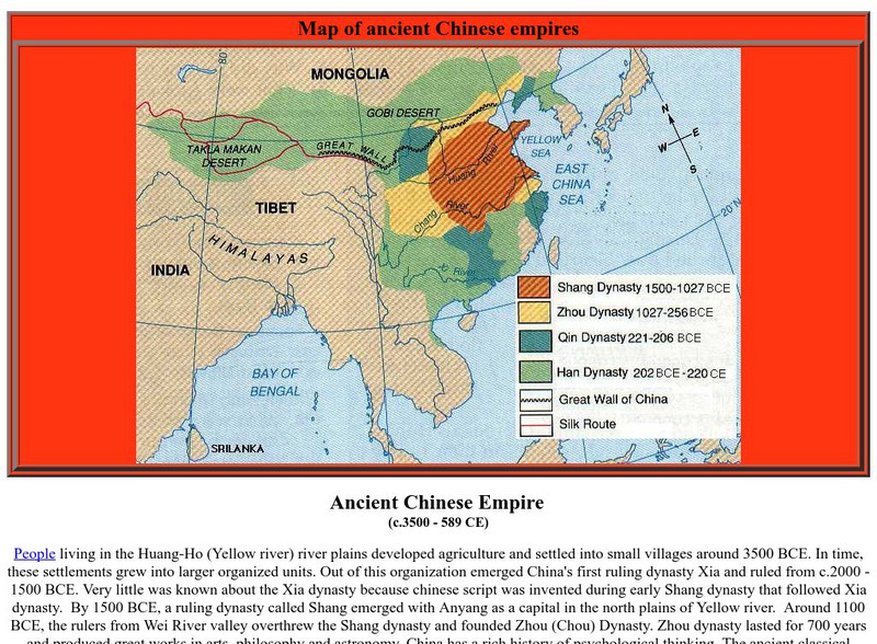
World Coin Catalog: Ancient Chinese Empire (C.3500 589 Ce)
At a site dedicated to coin collection, there is a great map of the ancient Chinese dynasties, about one sentence for the rise and fall of each dynasty, and links to ancient Chinese empire coin pages.
W. W. Norton
W.w. Norton & Company: Map of Zhou Dynasty, China
Presents a map of the Zhou dynasty's boundaries.
Other
World Heritage Sites in China
Information about historical and other sites in China that have been declared World Heritage Sites. Photos, virtual tours, and maps are available for sites like the Summer Palace in Beijing, the Great Wall, the Chengde Mountain Resort,...
Curated OER
Educational Technology Clearinghouse: Maps Etc: North China, 1971
" North China includes the densely populated and intensively cultivated North China Plain, the loess-covered uplands of Shansi, northern Shensi, and eastern Kansu, and the sparsely populated, semiarid steppes of Inner Mongolia....
Metropolitan Museum of Art
Metropolitan Museum of Art: Trade Routes Between Europe & Asia During Antiquity
Long-distance trade played a major role in the cultural, religious, and artistic exchanges that took place between the major centers of civilization in Europe and Asia during antiquity. Some of these trade routes had been in use for...
Curated OER
Top Story
This page contains great links to information about China. Student can click on the Imperial icon to access information about ancient China: timelines, dynasties, maps, archaeological treasures and inventions.


