Curated OER
System of Axes
In this system of axes worksheet, 10th graders solve and complete 1 word problem. First, they determine the figure shown in the illustration and set-up an expression. Then, students solve to find the shaded region of the diagram.
Curated OER
Linear Inequalities
Through exploration of linear programming through graphs and equations of inequalities, students relate linear programming to real life scenarios, such as business. Graphing and shading is also part of this exercise.
Curated OER
Wow! You're Eating Geography
Students examine patterns of food producing areas, and identify foods that are grown locally, in the U.S., and around the world. They map and graph the major food crops of their local area, the U.S., and other countries, and discuss the...
Curated OER
Micro-Climate
Atmosphere aces investigate the microclimates that exist within a larger area. They use a thermometer to record the varying temperatures and identify the microclimates on a map that they have drawn. This exercise helps them to understand...
Curated OER
Sand, Sand, Everywhere Sand
Students study the physical characteristics of four types of desert regions. In this desert regions lesson, students watch a video about deserts and discuss the deserts. Students compare the deserts and research the ways humans have...
Curated OER
Solid Rocket Boosters-II
For this solid rocket boosters worksheet, learners solve 2 problems using a grid showing a cross section of a proposed solid rocket booster. Students complete the grid and shade the rings of combustion in 15-second step intervals. They...
Curated OER
Systems of Linear Inequalities 2
Students solve systems of inequalities. In this lesson, they identify the solution of the two lines and shade the solution. They identify the boundary line and the region representing the solution.
Curated OER
Deserts
Students do various activities to explain where the United States' desert region lies in relationship to the state in which they live, become familiar with plants and animals in the Sonoran desert, and make a story map of Roadrunner...
Curated OER
Decimal Designs
In this decimals worksheet, students evaluate a set of 100 small cubes, some of which are shaded and some which are not. They then answer the first 6 questions by writing the decimal for the shaded and unshaded regions on the spaces...
Curated OER
SAT Grid Ins Practice Test 04
In this SAT Practice Test, students solve a variety of problems that range from solving for a variable, rate, probability, and area.
Curated OER
Map Activities
In this geography worksheet, learners follow the directions and shade 3 different regions of a UK political map, shade European Union countries on a political map of Europe, match 4 physical feature of Africa to their descriptions, and...
Curated OER
Places and Production
Students calculate United States GDP and GDP per capita, use a choropleth map to acquire information, and create choropleth maps of GDP per capita in South America. They identify regions with high and low GDP per capita
Curated OER
Arctic Microclimates
Students identify, measure, and average micro-climatic temperatures in a particular region. They draw a small-scale map of an area to be sampled (classroom, playground, park, backyard) and identify potential locations for...
Curated OER
Where's the Sand?
Students identify the characteristics of deserts. In this geography lesson plan, students discuss the characteristics of a desert and label a map with the names of deserts.
Curated OER
Most Troublesome Exotic Invasive Plant Species Web Quest
Young scholars participate in a Web Quest activity in which they identify common exotic invasive plant species of the Southern Appalachian Region. After identifying the top 10 exotic invasive species, they choose one to research in depth.
Curated OER
North Carolina Textured Landscape
Fourth graders explore the artistic ideas of landscape, foreground, middle ground, and background through a creative painting project. While this is written for North Carolina, teacher may adapt for any state/region.
Curated OER
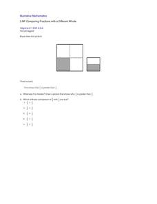
Comparing Fractions with a Different Whole
What was Bryce's mistake? Through analysis of a student work example, learners develop their own ability to compare the fractions one fourth and one half. Central to this activity is the concept that, when comparing fractions, the whole...
EngageNY
Multiplying and Dividing Rational Expressions
Five out of four people have trouble with fractions! After comparing simplifying fractions to simplifying rational expressions, pupils use the same principles to multiply and divide rational expressions.
Illustrative Mathematics
Do You Fit In This Car?
A short activity that focuses on the normal distribution as a model for data distribution. Using given means and standard deviations, your budding statisticians can use statistical tables, calculators, or other statistical software to...
Curated OER
Popping Up Bluebonnets!
students make 3-d bluebonnets Using popcorn and powder paint. They students create a field of bluebonnets on a bulletin board or wall space with their hand-made bluebonnets. students color leaves and stem of the bluebonnet outline with a...
Curated OER
Microclimates of Our School
Students read the story "Weslandia" by Paul Fleischman, define the term microclimate, gather and record data in various places on school grounds to establish the presence of difference microclimates, analyze and compare microclimates,...
Curated OER
Systems of Linear Inequalities
The class solves systems of linear inequalities. They graph lines and identify the point of intersection.They graph lines and identify the boundary that represent the solution and solution set.
Artisan Global
QuakeFeed Earthquake Map, Alerts and News
Amateur seismologists explore Earth's earthquakes in real time using a variety of map styles and parameter selections.
Illustrative Mathematics
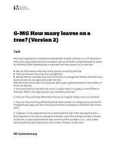
How Many Leaves on a Tree? (Version 2)
A second attack at figuring out the number of leaves on a tree, this activity makes both an excellent follow-up to version 1 and a stand-alone activity. Learners practice setting parameters and deciding acceptable estimate precision, and...


