Curated OER
A Comparison of Land and Water Temperature
Students examine NASA satellite observations of surface temperature and investigate the seasonal changes of land and water temperature.
Curated OER
Seasons and Cloud Cover, Are They Related?
Students use NASA satellite data to see cloud cover over Africa. In this seasons lesson plan students access data and import it into Excel.
Virginia Department of Education
Hurricanes: An Environmental Concern
Hurricanes, typhoons, and tropical cyclones are the same type of storm, but their names change based on where they happen. Scholars use a computer simulation to learn about hurricanes. Then they hypothesize ideas to prevent hurricanes...
Curated OER
It's So Sticky Outside That...
Students examine the phases of the water cycle and water's different forms it can have. They work in groups to create pantomimes to illustrate the water cycle to their classmates.
Curated OER
Flood Cycles 30/100 or Somewhere In Between
Learners examine traditional flood cycles. They research floods that have occured between 30 and 100 years. They use a tool known as Climprob to study precipitation patterns that might cause floods.
Curated OER
Am I Hot or Am I Cold?
Learners practice using a thermometer to determine how the air around the earth gets heated and cooled by the sun. Students chart the daily inside and outside temperature for two weeks.
Curated OER
Hurricane Frequency and Intensity
Students examine hurricanes. In this web-based meteorology lesson plan, students study the relationship between ocean temperature and hurricane intensity. They differentiate between intensity and frequency of hurricanes.
Curated OER
Does Cloud Type Affect Rainfall?
Student uses MY NASA DATA to obtain precipitation and cloud type data. They create graphs of data within MY NASA DATA. They compare different cloud types as well as precipitation types. They describe graphs of the precipitation and cloud...
Curated OER
Seasonal Cloud Cover Variations
Learners, in groups, access data from the NASA website Live Access Server regarding seasonal cloud coverage and the type of clouds that make up the coverage. They graph the data and make correlations between types, seasons and percentages.
Curated OER
Scientist Tracking Network
Students correlate surface radiation with mean surface temperature of several geographic regions. They observe how these parameters change with latitude and construct an understanding of the relationship of solar radiation to seasonal...
NASA
Earth's Global Energy Budget
Introduce your earth science enthusiasts to the earth's energy budget. Teach them using an informative set of slides that include illuminating lecturer's notes, relevant vocabulary, embedded animations, colorful satellite maps, and a...
NOAA
El Niño
El Nino, La Nina ... and the Santa Maria? The 11th installment of a 23-part NOAA Enrichment in Marine sciences and Oceanography (NEMO) program explains the mechanism of El Nino/Southern Oscillation. Pupils use previous data to determine...
NOAA
The Biogeochemical Cycle
The biogeochemical cycle ... no physics? The fourth installment of a 23-part NOAA Enrichment in Marine sciences and Oceanography (NEMO) program introduces the biogeochemical cycle by having pupils simulate movement between Earth's...
Curated OER
Solar/Lunar Eclipses and the Seasons
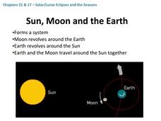
How do the moon, sun, and Earth line up to create eclipses? Why do the seasons change throughout a year? The answers to these questions are explained through this series of slides. This apt presentation outlines information using bullet...
Curated OER
The Water Cycle
Your class sets up a mini water cycle model to examine the process. Then they watch an animation, following a water molecule through the cycle. A well-developed lab sheet guides learners through the lesson and a PowerPoint presentation...
Rainforest Alliance
Forests of Guatemala
With 90 percent of its land area covered in forests, Suriname, a country in South America, contains the largest percentage of forests throughout the world. Here is an activity that brings classmates together to learn about the...
Curated OER
Earth's Water
If the majority of our planet is covered with water, why do we need to bother conserving it? With a thorough and varied investigation into the location and types of water on the earth, learners will gain an understanding of why this...
Curated OER
Water in Earth's Hydrosphere
Environmentalists test stream water for temperature, pH, and turbidity. Each group shares their information and then the class makes an overall evaluation of the water quality. A slide show sets the backdrop for the teaching portion and...
Curated OER
Classification of Clouds
Students view progressive slides of cloud formations and identify which type of cloud is shown as it forms. They estimate the cloud's height while viewing each image.
Curated OER
Classification of Clouds
Students view a cloud slide show presentation and identify types of clouds. They estimate height based on cloud's appearance. They discuss the vague nature of cloud nomenclature and compare it to the English standard measurement system.
Curated OER
Trends of Snow Cover and Temperature in Alaska
Young scholars compare NASA satellite data observations with student surface measurements of snow cover and temperature. They practice data collection, data correlations, and making scientific predictions.
Curated OER
Trouble in the Troposphere
Pupils Use data sets from MY NASA DATA to produce graphs comparing monthly and yearly ozone averages of several U.S. cities. They analyze and evaluate the data and predict trends based on the data. In addition, they discuss and describe...
Curated OER
Trouble in the Troposphere
Students create graphs using NASA data, compare ozone levels of several U.S. cities, analyze and evaluate the data and predict trends based on the data, and discuss and describe how human activities have modified Earth's air quality.
Curated OER
Does Humidity Affect Cloud Formation?
Students use NASA's S'COOL database to identify factors that affect cloud formation.


