Goodwill Community Foundation, Inc.
Directions and Distances
Describe where you are—and find out where you are going—with a beginning Spanish resource on directions and maps. Spanish learners repeat and practice direction words such as norte, este, and oeste, as well as measurement terms such as...
Curated OER
Story Mapping A Favorite Book
First graders create a diagram of a story by using the computer program Kidspiration. In this diagramming lesson plan, 1st graders will pick a book to write about. They then will plug in story elements of the book into the computer...
Curated OER
The Amazing PE Race
Students utilize map reading skills, perform locomotor movements, and practice skills as they make their way through the Amazing PE Race. They use a map of school grounds to collect clues around the building.
Curated OER
Where Am I?
High schoolers apply map reading skills by locating places through the use of latitude and longitude.
Curated OER
Finding Your Way
Students work in small groups to practice basic map skills. They take turns giving directions and tracing a path from one location to different destinations on the map.
Curated OER
Navigation
Young scholars explain that globes are the best way to show positions of places, but flat maps are portable and can show great detail. They make a mercator projection of the route Lewis and Clark took on their journey.
Curated OER
Follow the Light
Students investigate the role of lighthouses in navigation and practice the use of cardinal directions through reading activities, discussion, locating geographical features, and mapping lighthouses along the east coast of the United...
Curated OER
Locomotor Treasure Hunt
Students practice in refining their locomotor skills and developing their understanding of pathways and basic map reading skills.
Curated OER
Mapping a Garden
Second graders recognize the components of a map, particularly the legend, the key, the symbols and the area. They develop their own map of a garden they be planting in their upcoming science lesson.
Curated OER
Chinese, Japanese, and Korean Language Basics
Pupils in seventh and eighth grade Introduction to Foreign Language class are introduced the basic greetings, farewells, courtesy words, and basic phrases in Mandarin Chinese, Japanese and Korean. In pairs, they create a very short...
Curated OER
Welcome to My World!
Students use maps to locate information. They read the story, "It Looked Like Spilt Milk", view images of the continents and discuss the various continents. Afterward, they make their own Atlas to record information that they can later...
Curated OER
Mapping an Empire
How did the expansion of the Roman Empire during the first century contribute to its downfall? Using a map of the Roman Empire in 44 BC and one of the Roman Empire in 116 AD as references, class member use critical reading skills to...
Curated OER
Johnny Appleseed Walkabout
Second graders calculate mileage for a journey. In this place value and measurement lesson, 2nd graders read Johnny Appleseed, work in groups to locate his birthplace on a map, locate the other states he stopped in, and measure the...
Curated OER
Tracking Satellites Using Latitude and Longitude
Students, viewing an Internet site, plot the path of several satellites using latitude and longitude over the course of an hour. They learn the four basic types of satellites and their purpose.
Curated OER
Arthur's Nose
Students read a story and complete a story map. In this diversity and acceptance lesson, students read Arthur's Nose, make a story map, research Aardvarks, complete a Venn Diagram comparing Arthur's nose to other animals in the...
Curated OER
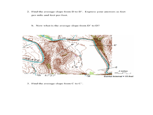
Slope and Topographic Maps
Learners investigate slopes as they study topographic maps. In this algebra lesson, students discuss and apply the concept of slopes to graphing and analyzing data.
Curated OER
Where in the Latitude Are You? A Longitude Here.
Students distinguish between latitude and longitude on the map. In this mapping lesson, students participate in mapping skills to recognize spatial relationships, and where to find natural resources on the map. Students create...
Curated OER
Right Place, Right Time
Fourth graders complete mathematical word problems. They study the relationships among distance, speed, and time; and measure travel distances. They measure distances using a piece of string and a ruler and practice converting several...
Curated OER
Mapping the Local Community
Students review the symbols and legends of a map. In groups, they follow a set of directions to create a map showing the route to a specific place. They present their map to the class and review the basic components of a community.
Curated OER
Reading a Map
Third graders become familiar with the vocabulary and skills related to mapping. In this guided reading lesson plan, 3rd graders find proper nouns on from the map. Students read Goldilocks. Students make...
California Polytechnic State University
Australian Geography Unit
At the heart of this resource is a beautifully detailed PowerPoint presentation (provided in PDF form) on the overall physical geography of Australia, basic facts about the country, Aboriginal history, and Australia culture and lifestyle.
University of Southern California
What Is The Ocean?
Go on a tour of the ocean through the lens of a scientist. Learners read maps of the ocean floor, study tide behavior, examine wave motion, and analyze components of soil. Each lesson incorporates a hands-on component.
Curated OER
Using Word Maps to Expand Vocabulary
Looking for a good lesson on dictionary and word definition skills? The lesson presented here is for you! In it, learners utilize a worksheet, embedded in the plan, to record a word's definition(s), etymology, multiple meanings,...
Houghton Mifflin Harcourt
Journeys: Challenge Activities (Theme 1)
This nine-page packet, the first in the series of support materials for the Houghton Mifflin Harcourt thematic units on journeys, contains enrichment activities for learners who have mastered the basic concepts of the lessons....


