Curated OER
Location, Location, Location!
Twelfth graders locate cities, states and countries on maps. They use the cardinal directions to locate places on maps. They describe where they were born by giving clues without naming the exact state. They trade papers and try to guess...
Curated OER
Latitude and Longitude- Online Interactive
In this maps learning exercise, students learn about longitude and latitude by reading a two paragraph text and studying two maps. Students answer 9 fill in the blank questions. This is an online interactive learning exercise.
Bismarck Public Schools
Chapter 9 Review WKST
Here is a traditional multiple-choice, true/false, and fill-in-the-blank assessment on the presidency of James Monroe in the United States. It was designed to supplement a particular textbook chapter, but could be used to assess learning...
Curated OER
Past Tense Verbs- Fill In the Blank
In this past tense verbs worksheet, students fill the blank lines with the correct form of the verb which is given in parentheses at the end of the sentence. They complete 30 examples.
Curated OER
States and Capitals, Mountains and Rivers
Students identify geographical locations in the midwestern United States. In this geography lesson, students identify 12 states and capitals and geographical features in the region by using U.S. maps. Students use blank maps to fill in...
Curated OER
School Neighborhood Walking Tour
Students list specific boundaries in their school neighborhood and explain their possible purpose. They examine a neighborhood and see what connects us and what divides us. They, in groups, make maps of various neighborhoods and present...
Curated OER
Journey of Discovery and Rivers
Learners investigate the rivers encountered and mapped by the Corps of Discovery. They analyze maps, outline and label rivers on a blank map, complete a chart, and answer discussion questions while watching a National Geographic video,...
Curated OER
The 50 States and its Holidays
Though the format of this ELL lesson is confusing (the standards listed are for plate tectonics, yet the objectives are for American geography and holidays), a teacher could glean some ideas from the main idea. Here, pupils complete a...
Curated OER
Family Quilts Keep Us Warm
Pupils explore different types of families and cultures. They create a paper quilt with geometric designs of similar colors to show unity and pictures of each of their families to show diversity.
Curated OER
Where In the World Are You?
Fourth graders fill in blank copies of the United States Map and then the World Map.
Curated OER
Media Center Map Skills
Student demonstrates the ability to locate, retrieve, and handle media and equipment by utilizing the library media center floor plan, symbols, and guides. They then use systems of classification to identify, locate, and retrieve materials.
Curated OER
Which Way Did He Go?
In this visual thinking worksheet, 5th graders determine which of three routes that Max should take to get to a party by noon. Students answer 10 fill in the blank questions relating to different amounts of time and miles.
Curated OER
Simple or Progressive
Proper verb usage is reviewed in this learning exercise. Students fill in the blanks in 10 multiple choice questions relating to verbs.
Curated OER
To & For
Using the words to and for is covered in this activity. Learners can practice important skills by identifying the correct word for use in each blank on the 10 question quiz.
Curated OER
Lie & Lay
When do you use "lie," and when do you use "lay"? Use this worksheet in your ESL class to find the difference. Ten questions provide sentences with blanks for English learners to complete with the two verbs, often in different tenses....
Curated OER
Digging For Dinosaurs
In this dinosaur themed worksheet, students work together as a team of paleontologists to draw the dinosaur bones they discovered at a dig site. They must label their drawing on a grid map and then provide data about the length and...
Curated OER
Using Google Squared to Compare and Contrast Canada and the US
Sixth graders compare and contrast Canada and the United States. In this geography skills lesson, 6th graders use Google Squared to research information so that they may compare the geography of Canada and the United States.
Curated OER
Basic U.S. Geography
Provide your 11th graders with a basic understanding of U.S. Geography. They label the state, regions, and boundaries found in the contiguous U.S. as well as Hawaii and Alaska. Then, they complete two Internet related activities.
Curated OER
Hurricane Frequency: Identifying Regions with Similar Numbers of Hurricanes
In this earth science worksheet, students answer 6 questions about the hurricane map and data provided. They create a data table based on the information provided on the map.
Curated OER
The First North Americans
Students identify and interpret the different North American Indian groups, by region, and the type and impact of their interaction with Europeans.
Then they complete an overview of one main Native American group during the age of...
Curated OER
Seven Daughters and Seven Sons: the Middle East Through
Sixth graders read "Seven Daughters and Seven Sons" and examine aspects of Middle East culture and geography. They define vocabulary from the book and map locations described in the book.
Curated OER
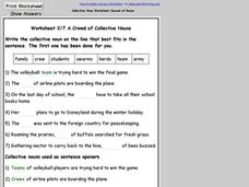
Worksheet 2/7 on Collective Nouns
In this recognizing collective nouns worksheet, students use collective nouns in a word bank to fill in the blanks in sentences. Students write 7 answers.
Curated OER
Weather Patterns and Acid Rain (or What is Chicago's acid rain doing in the Adirondacks?)
Students examine a color-coded map of U.S. acid rain precipitation intensity. Using EPA data table and the blank U.S. map, they record state-by-state values for magnitude of emissions and compare areas of emissions to areas with the most...
Curated OER
Learning About the Equator, The Seven Continents and the Four Oceans
Students use a globe or map to locate the equator, oceans and continents. Using the internet, they spend time surfing through predetermined websites on continents and oceans. They write facts on different parts of the globe on index...


