Curated OER
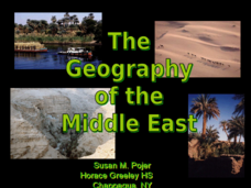
The Geography of the Middle East
Topographic, political, and satellite maps establish the world of the Middle East for your class- a land about which they have heard quite a lot, but might not really understand. This presentation would be a good introduction into a unit...
Curated OER
The Geography of Latin America
Perfect for a geography or world cultures lesson, the slides in this presentation cover the topography, demographics, and climate of Central America, South America, and the Caribbean. From the apex of the Andes Mountains, to the depths...
Curated OER
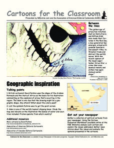
Cartoons for the Classroom: Geographic Inspiration
A wonderfully graphic cartoon entices learners to read more about issues near the Arabian Peninsula. They will use the provided cartoon and critical thinking question to practice building their analytical and critical thinking skills....
Curated OER
Coasts and Reefs: Shallow Marine Processes
A more thorough presentation on coastal systems would be difficult to find! Detailed diagrams illuminate the offshore, shoreface, foreshore, and backshore zones of beach. The sources and movement of sediments along the coastline...
Curated OER
Introduce Vocabulary: Curious George Rides a Bike (Rey)
Are your learners curious about new words? Take them on an adventure with Curious George as they learn vocabulary in the context of H.A. Rey's book, Curious George Rides a Bike. Prepare budding readers by introducing the terms...
University of Miami
What is it? Weathering, Erosion, or Deposition?
Just as rocks move through the rock cycle, your giddy geologists will move descriptions around until they are all in the correct category. After cutting out several types of rock movement, learners determine whether the action is...
Sharp School
Geography Project
This very simple geography project can lead to a lot of useful referential information that can be displayed in your classroom! Learners construct a poster-size map of a country, identifying major demographic points and including pie/bar...
Curated OER
State or Region Project
Invite your youngsters to learn about a state or region through their choice of a creative project. The resource lists 15 project options that range from a 3-D map of the area, to a puppet show about the region. Pupils can also propose...
K5 Learning
Rocks
Five short answer questions follow an informational reading passage that details the three different types of rocks—sedimentary, igneous, metamorphic—and their rock cycle.
Massachusetts Institute of Technology
Sentence Structure of Technical Writing
Most teachers and scholars look for a way to simplify information. Informational how-to slides simplify the process of technical writing into a step-by-step process. Learners gather information on what to do, as well as what to avoid....
Curated OER
Geography Challenge
In this geographical features worksheet, students read the 10 statements about geographical features. Students select the correct to complete 10 statements.
Curated OER
Explore Surface Types on a Journey Around Earth
Students explore satellite data. In this technology cross-curriculum math and world geography lesson plan, students locate specific map areas using a microset of satellite data. Students use technology and math skills to determine...
Curated OER
The History of Ancient Greece
Present facets of Ancient Greek life and politics through direct instruction. Middle schoolers learn about to Greek City States, Sparta, Athenian Democracy and the Peloponnesian War by way of a class lecture. They use their text books to...
Curated OER
Zebra Mussels
In this zebra mussels worksheet, 7th graders read an article about zebra mussel populations in United States' lakes and rivers. Students read about the negative effects and some positive results and then answer several questions about...
Curated OER
Buoyancy: Who Sank the Boat?
Students examine whether objects will sink or float. In this buoyancy instructional activity students bring in objects and experiment to see if they sink or float.
Curated OER
Hunt the Fact Monster
In this Fact Monster search engine worksheet, learners access the Internet to one specific website to find the answers to five questions with multiple choice answers.
Curated OER
Geography: Physical Features
Physical features in our geography are outlined in this colorful PowerPoint. First, different physical features are listed. Then, they are defined with a corresponding graphic. Tip: While presenting this slideshow to your class, ask them...
Curated OER
Geography of South America
Student's identify geographic features of a South American map. They use the scale of the map to calculate distances between points. They identify examples of the five geographic themes on the map of South America.
Curated OER
Iraq, Where's That?
Students identify the Middle Eastern countries on the map and the oil-producing countries of OPEC in the region. They examine whether the presence of important producing oil fields qualifies as a characteristic of this region.
Curated OER
Aquatic Life
Sixth graders work in pairs to research information related to aquatic life using references from the World Wide Web. They present their findings in the form of an oral presentation to the class.
Curated OER
Travelogs
Students make travelog journals to send to acquaintances in other states in order to receive mail in return. They make scrapbooks with the return mail they receive.
Curated OER
Building Bridges
Students identify the different types of bridges. Using the internet, they research information on how they are built by completing a scavenger hunt. Locating a specific area, they determine which type of bridge would be appropriate and...
Curated OER
Introduction to the Civilization of Ancient Greece
Students realize Greece's location in relation to the previously learned civilizations and learn the vocabulary needed for this unit of study. They use the interactive SMART board to locate places and learn necessary information of...
Curated OER
U.S. and Canada: How are We the Same? How are We Different?
Get high school geographers to compare and contrast Canada and the United States. They begin by drawing a freehand map of North America, then complete readings to gain insight into Canada. The text is not provided; however, another text...
Other popular searches
- Landforms and Bodies of Water
- Major Bodies of Water
- Bodies of Water/rivers
- Bodies of Water Lesson
- Identifying Bodies of Water
- Different Bodies of Water
- Bodies of Water 101
- Water Bodies
- Bodies of Water Word Scramble
- Landforms and Water Bodies
- Earth's Bodies of Water
- Healthy Bodies Water


