Curated OER
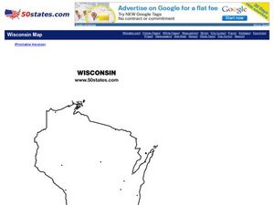
Wisconsin Outline Map
In this Wisconsin outline map worksheet, students examine political boundaries of the state and the placement its capital city as well as its major cities. This map is not labeled.
Curated OER
West Virginia Outline Map
In this West Virginia outline map worksheet, students examine political boundaries of the state and the placement its capital city as well as its major cities. This map is not labeled.
Curated OER
Washington Map
In this Washington state outline map worksheet, students examine political boundaries of the state and the placement its capital city as well as its major cities. This map is not labeled.
Curated OER
Virginia cities
In this Virginia cities activity, students fill in the map with the cities in Virginia next to the dots on the map. Students fill in 8 cities including the capital.
Curated OER
Vermont
For this Vermont worksheet, students fill in the cities in Vermont into a map with dots on it for where the cities are located. Students fill in 7 cities including the capital.
Curated OER
Utah Outline Map
In this Utah outline map worksheet, students examine political boundaries of the state and the placement its capital city as well as its major cities. This map is not labeled.
Curated OER
Tennessee Outline Map
In this Tennessee outline map worksheet, students examine political boundaries of the state and the placement its capital city as well as its major cities. This map is not labeled.
Curated OER
South Dakota Outline Map
In this South Dakota outline map worksheet, learners examine political boundaries of the state and the placement its capital city as well as its major cities. This map is not labeled.
Curated OER
Rhode Island Outline Map
In this Rhode Island outline map worksheet, students examine political boundaries of the state and the placement its capital city as well as its major cities. This map is not labeled.
Curated OER
Map of India
In this map of India activity, students label the capital city, the bodies of water and the compass points, then color the surrounding colors according to directions.
Curated OER
A Passport to Asia
Middle schoolers explore Asia. In this geography skills lesson, students design travel brochures that market Asia by highlighting its location, population, capital, landforms, famous places, and food.
Curated OER
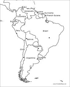
South America Outline Map
In this outline map worksheet, students discover and investigate the physical boundaries of the countries in South America. The names of countries and a star to mark the capital city are included.
Curated OER
Mexico and Central America Map
In this blank outline map worksheet, students study the political boundaries of Mexico and Central America. Each of the counties is labeled and the capital cities are starred.
Curated OER
South America Outline Map
In this blank outline map instructional activity, students explore the political boundaries of South America and the nations there. This map may be used in a variety of classroom activities. The location of the capital cities are...
Curated OER
Our Country's Geography
Third graders study geography. In this United States landforms instructional activity, 3rd graders create a map of the U.S. made out of dough. They use various edible treats to mark the country's capital, the plains, the mountains and...
Curated OER
Acquiring Additional Capital Stock
Students become involved in the practice of learning about finance. The emphasis is on how one uses the stock market. One can also learn how to use personal finance and become acquainted with debt management.
Curated OER
European Capital of Culture 2008
Students explore the meaning of culture. They read and discuss news stories concerning cultural cities. Students design and create a campaign poster and text that demonstrates why a particular city should be known as a place of culture.
Curated OER
Careers in the Capital
Students explore the role that the president plays in appointing persons into the Cabinet or White House positions. Various positions that they might like to hold are researched and the changes that a new administrations creates in those...
Curated OER
Capitol vs. Capital
Students construct time lines to show the order of significant events in Ohio history. They explain how Ohio progressed from territory to statehood.
Curated OER
State Poster Fair: US Geography, Social Science, Art
Students research a US state, design and construct a state 'poster' to display important facts about that particular state. They present their work to the class.
Curated OER
Balance of Payments (BOP)
Learners work through ten transactions that will help them understand credits and debts on a global scale. They then discuss each transaction in terms of the global economy. An extension activity and discussion questions are included.
Curated OER
Chapter 39: The Economics of Developing Countries
The disparity between the standards of living in industrialized countries versus developing countries has gotten wider - and this presentation can help your class learn why. With a multitude of key definitions and facts, these slides go...
Council for Economic Education
Balance of Payments (BOP)
Have you ever checked your clothes to see how many nations created them? Pupils take a deeper look at international trade and the balance of payments nations have with one another. They use calculations, simulations, and primary sources...
Curated OER
4-H Citizenship Activity Page - Beginning Level
This is a 4-H citizenship activity that asks learners to examine county government, city councils, the three branches of the United States government, and complete a community service project. It also includes a word search, directions...
Other popular searches
- Socialism and Capitalism
- Socialism vs Capitalism
- Capitalism Socialism Communism
- Socialism Capitalism


