Mathematics Assessment Project
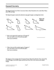
Hopewell Geometry
Right triangles from 2,000 years ago? Learners investigate different right triangles found in the earthworks of the Hopewell people, a Native American culture that populated the United States from 200BC to AD 500. Learners apply concepts...
Curated OER
Geography: African Floor Maps
Students explore the African continent and identify the various countries there. They examine the history, geography, environment, and inhabitants of the countries. Students create maps of Africa using a variety of materials.
Curated OER
Maps
First graders look at their classroom or school setting. They use positional word to describe where things are located in the school. Students discuss a map and why they are important. They read the story "Taylor's New School" and...
Curated OER
Mapping A Stream
Pupils participate in mapping an actual waterway. They include reach lengths, transects, compass reading, and scale determinations. They include windfalls, plant cover, types of streambed composition, and landmarks such as trees and...
Curated OER
Mapas Bailados: Creating Visual Representations of Dances Using Maps
Third graders listen to "Frank the Monster..." and discuss the dance map on the inside cover of the book. They create their own dance map using sentence strips to record the types of movement.
Curated OER
Mapping Your Neighborhood
Pupils define and outline their neighborhoods using GIS (geographic information systems) or a regional map and relate their neighborhoods to the principles of Smart Growth.
Curated OER
Graphin' And Glyphin' Utah Weather
Fourth graders investigate the concepts of looking at sets of data. The focus of the study is upon the local weather of Utah. They study the weather found in the city and in the country and make comparisons based upon geographical location.
Curated OER
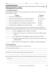
Viewing Earth and Sky
In this earth and sky worksheet, students review terms associated with map reading. Students also review topographic maps and how contour lines represent elevation. This worksheet has 5 matching, 5 true or false, 5 fill in the blank, and...
Curated OER
Where in The World Am I?
Students explore the concept of absolution location. In this geography skills instructional activity, students discuss how to identify and locate latitude and longitude. Students play a game to reinforce the skills.
Curated OER
Follow That Ship!
Students in this exercise are introduced to the distinct ways of measuring distance (nautical miles) and speed (knots) at sea, as well as the concepts of latitude and longitude for establishing location.
Think Like A Programmer! Puzzlets Cork the Volcano Curriculum
Common Core Standards Connected
The standards listed below are standards from the Common Core Framework which map to learning opportunities with Cork The Volcano & Puzzlets.
Source Link: http://www.corestandards.org/
Grade...
Curated OER
RIDING THE WIND
Students locate the Trade Winds, Westerlies and Polar Easterlies on a map, explain the impact of the rotation of the Earth, and plot a route for a round trip voyage from New York to London.
US Mint
Absolutely and Relatively: The Puerto Rico Quarter Reverse
How much does your class know about Puerto RIco? How much can they learn from the back of a 2009 quarter? Use the coin, part of a series of quarters that depict US territories, to teach learners about the geography, culture, and history...
Mathematics Assessment Project
Evaluating Statements about Probability
Learners first complete an assessment task where they assess statements on probability. They then sort cards containing probability statements as being either true or false.
Curated OER
Arkansas: A Natural State
Here is a wonderful lesson on natural resources found in Arkansas which is designed for kindergartners. The lesson could be easily adapted for any state. Some clever in-class activities, games, and a song are included in this...
Curated OER
Building a School Model: An Academic Challenge
First and second graders explore aspects of design. They discuss and design the ideal classroom building complete with window and door placement. Additionally, students observe and note features found in neighboring classrooms as...
Mathematics Assessment Project
Modeling Motion: Rolling Cups
Connect the size of a rolling cup to the size of circle it makes. Pupils view videos of cups of different sizes rolling in a circle. Using the videos and additional data, they attempt to determine a relationship between cup measurements...
Curated OER
Location on a Grid
Make coordinate pairs more engaging by having beginners color-code a grid based on given locations. The grid has numbers along the y-axis and letters along the x-axis, introducing them to the ordering of coordinate pairs with the x-axis...
Mathematics Assessment Project
Estimating Volume: The Money Munchers
Don't stuff money under your mattress. To find out why learners first complete a task determining how $24,000 in cash would affect the height of a mattress and whether this same amount would fit into a suitcase of given dimensions. They...
Mathematics Assessment Project
Increasing and Decreasing Quantities by a Percent
As part of a study of percent and percent change, learners first complete an assessment task with several percent change problems. They then complete an activity using cards to create a diagram expressing percent increases and decreases...
Mathematics Assessment Project
Estimating Length Using Scientific Notation
Would you rather have a million dollars or 1 x 10^6 dollars? To find the answer to this question, class members first complete an assessment task converting numbers between decimal notation and scientific notation. They then take part in...
Curated OER
Cross-Cultural Dialogue Lesson
Students read and analyze a personal narrative written about a Peace Corps Volunteer teaching English in Guinea-Bissau, Africa. They discuss the concept of crossing cultures, analyze maps, complete worksheets, and develop a writing...
Curated OER
Silk Road Treasures And Traders
Students investigate the concepts that are related to the Silk Road trading route. They conduct guided research using a variety of resources. The information is used in order to use a shoebox and draw a map of the Silk Road upon it.
Curated OER
The Era of Good Feelings
Setting the context for the first part of the 19th century, the slides presented here display the "Era of Good Feelings," including the presidencies of Monroe and Adams. Maps and photographs help students to contextualize the concepts of...
Other popular searches
- Cell Transport Concept Map
- Blank Concept Maps
- Genetic Concept Map
- Weather Concept Map
- Krebs Cycle Concept Map
- Science Concept Map
- Phylum Chordata Concept Map
- Concept Map Rubrics
- Inspiration Concept Map
- Dna Structure Concept Map
- Concept Map in Science
- Rock Concept Maps


