Mathematics Assessment Project
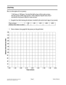
Journey
Drive home math concepts with an engaging task. Learners follow a verbal description to fill in a table and create a distance-time graph representing a car journey. They then answer questions by interpreting the graph.
Mathematics Assessment Project
Table Tiling
How many total tiles does it take to tile a table top? Learners apply geometric concepts to determine the number of tiles needed for a specific square table top, and then use the result to create expressions for the number of tiles...
Mathematics Assessment Project
Temple Geometry
Temper your excitement of temple geometry. Using algebraic and geometry concepts to determine various measurements in a circle diagram, scholars determine the shaded area of the diagram.
Mathematics Assessment Project
Generating Polynomials from Patterns
Patterns and polynomials go hand in hand. Budding mathematicians analyze sequences of dot diagrams to discover the patterns in the number of white dots and black dots. They use the identified patterns to write and simplify a polynomial...
Curated OER
Where is the Trail? The Journey of Lewis and Clark
Students explore the trail followed by Lewis and Clark on their journey across the United States. In this United States History lesson, students complete several activities to establish the Lewis and Clark Expedition, including a class...
Curated OER
Tracking Satellites Using Latitude and Longitude
Students, viewing an Internet site, plot the path of several satellites using latitude and longitude over the course of an hour. They learn the four basic types of satellites and their purpose.
Curated OER
Valentine City
Students construct a small city on a table in the classroom. Each student is given a lot to develop. They give directions from one location to another, and write letters with correct addresses to their classmates.
Curated OER
Ticky Plans His Trip to Antarctica to See Tacky
First graders participate in a creative problem solving activity to help Ticky get to the Atlantic Ocean. They identify Ticky's problem, brainstorm ways to solve the problem, and develop a plan. They write the steps Ticky needs to take...
Curated OER
Where in the World? The Basics of Latitude and Longitude
Students are introduced to the concepts of latitude and longitude. In groups, they identify the Earth's magnetic field and the disadvantages of using compasses for navigation. They identify the major lines of latitude and longitude on a...
Curated OER
Longitude and Latitude Lines
In this geography worksheet, learners examine the map and focus on the concept of latitude and longitude by finding the locations.
Curated OER
Story Hour with Lincoln
Students explore the life of Abraham Lincoln. In this Abraham Lincoln lesson, students create a Lincoln beard and hat to wear. Students view the penny and discuss why he was chosen to be pictured on the penny. Students create Lincoln...
Curated OER
Devising a Measure for Correlation
How well does your class understand the concept of correlation? Use an activity to explore different methods of calculating correlation. Working alone and then in groups, your class will make decisions on what math to apply to the...
Curated OER
Organizing Main Ideas and Supporting Details
Students read given information and identify the main ideas and specific detail of the story. In groups, they read a historical title and create a "book talk" for each one, summarizing the story. In addition, students create a...
Curated OER
The Future of Social Studies Education
Learners work in groups of four and complete a roster of their names and personal information and to complete a release form that allows their pictures to be placed online. They then engage in classroom activities while being...
Curated OER
California Indians
Fourth graders discuss the major nations of California Indians, their geographic distribution, economic activities, legends and religious beliefs. They describe the function of Spanish missions and the influence of Catholicism. In...
Curated OER
Aztec History
Students explore facets of Aztec history. In this ancient civilizations instructional activity, students map landmarks in Mexico, read excerpts from The Sad Night: The Story of an Aztec Victory and a Spanish Loss, by Sally Mathews and...
Curated OER
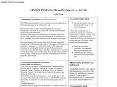
Lesson Plan of a Thematic Project - Water
Sixth graders investigate the properties of water. In this life science instructional activity, 6th graders create a concept map of water. They share their work with the class.
Curated OER
Why Not Visit My Country?
Students research a country using the Travel Languages Web site. Using MS Publisher, they create a travel flyer about the country. Using Inspiration, they develop a concept map of what they learned about their country.
Curated OER
Quarters from the Coast
Students examine the Maine state quarter and discuss the features on the quarter that identify Maine as a coastal state. They identify coastal states and inland states on a map.
Curated OER
Mapping The Way With Lewis & Clark
Fourth graders analyze and compare maps used on the expedition of Lewis and Clark. Students write reports about the geography of the land. They answer questions about Lewis & Clark.
EngageNY
Mid-Module Assessment Task: Grade 8 Module 2
It's time for a concept check! Check for student understanding over the three types of rigid transformations. The assessment follows the first 10 lessons in this series and to test pupils' proficiency of these concepts. Individuals...
Science Matters
Slip Sliding Along
The San Andreas Fault is the largest earthquake-producing fault in California. In the seventh lesson in the 20 part series, pupils create maps of California, focusing on the San Andreas Fault system. The comparison of where California is...
NOAA
Tracking a Drifter
Be shore to use this drifter resource. The third installment of a five-part series has learners using the NOAA's Adopt-a-Drifter website to track to movement of a drifter (buoy) in the ocean. Graphing the collected data on a map allows...
Curated OER
Linguistic Diversity. Languages in Canada - Elementary
Create a language mosaic to reveal the linguistic diversity in your community. Pupils interview a person with a home language other than English and contribute to a bulletin board display representing the variety of languages spoken. The...


