Curated OER
Building A Topographic Model
Students visualize, in three dimensions, features represented by contour lines on a topographic map. They see that the different elevations shown on a two dimensional topographic map can be used to build a 3-D model.
Curated OER
Igneous Rock Formation
Fifth graders use the computer lab to search for answers to questions on their workshet. They discuss the creation of igneouss rocks and listen as the teacher lectures about lava. Students follow directions to mix a batch of salt dough...
Curated OER
Pangaea Puzzle
Students explore plate tectonics and the formations of the Earth's surface and why maps are distorted. In this Earth's surface lesson students complete a lab and answer questions.
Curated OER
Geology and the Battle of Gettysburg
Students create geologic maps of the Gettysburg battlefield. In this geologic skills lesson, students consider the variations of Earth's surfaces and explore strategies employed by the North and South in the Battle of Gettysburg to...
Curated OER
Hurricane Tracking
Students access the Internet to find information on current hurricanes. They get locations, speeds, and air pressures and then plot the location of the hurricane on a hurricane-tracking map. They also access the FEMA website to solve...
Curated OER
Year 3 Geography
In this social studies worksheet, learners find the words that are related to the concepts found in Geography and the answers are found at the bottom of the page.
Curated OER
Silicates
In this silicates worksheet, students are given the names of 6 different silicates in the form of a concept map. Students define each type of silicate in the map.
Curated OER
Giving Directions
Students explore communication by participating in language description activities. In this directions lesson plan, students practice using communicative terms and prepositions of places to direct a classmate to an exact location....
Curated OER
Lead Usage Through History
Learners read 2 assigned articles about lead usage with a partner or team. They create a concept map or timeline using Inspiration software to trace the uses of lead by people. They complete a brief constructed response and are graded...
Curated OER
Rooting One's Way To Meaning
Young scholars use a thesaurus on the internet to explore the meanings of Greek and Latin roots. They find definitions of given words, draw a concept map for root words, and write four synonyms for each word. Students discover how Latin...
Curated OER
Chemical Changes or Reactions
In this chemical changes worksheet, students create a concept map for chemical changes or reactions. They indicate the definition, the description, they give examples and they give non-examples in a graphic organizer.
Alabama Learning Exchange
Diverse Life Forms of the Ocean
High schoolers recognize marine organisms and differentiate between plankton and nekton. For this investigative instructional activity students create a concept map using their list of terms and study marine life forms.
Curated OER
Classify Rocks
Students classify different types of rocks. In this earth science instructional activity, students test different rock samples and construct a chart to record observations. They create a concept map that answers essential questions.
Curated OER
Rainfall Mapping
Students explore rainfall and habitats. In this rainfall instructional activity, students explore the relationships among rainfall, vegetation, and animal habitats. Resources are provided.
Curated OER
Concept: Points on a Grid
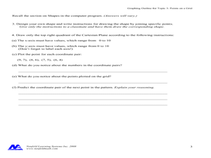
In this coordinate grid graphing worksheet, students play a game of Battleship on the computer. They answer 21 questions about the coordinate grid and graphing.
Curated OER
Beary O'Mometer Learns About Careers In Meteorology
Students explore the field of meteorology. In this meteorology lesson, students explore weather-related careers as they research the field of study as well as various weather concepts. Students interview meteorologists, write business...
Core Knowledge Foundation
Columbus Sailed the Ocean Blue
Young adventurers embark on a journey, setting sail along the blue ocean with Christopher Columbus. Teachers will find that this unit makes their lesson planning smooth sailing!
Curated OER
Fresh Water and land of Kiribati and Hawaii (Molokai)
Fourth graders examine the islands of Hawaii. Using this information, they organize it and create a map or graph that represents the data. As a class, they discuss how the watersheds on the islands are different and how people react to...
Mathematics Assessment Project
Hopewell Geometry
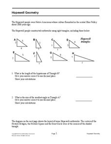
Right triangles from 2,000 years ago? Learners investigate different right triangles found in the earthworks of the Hopewell people, a Native American culture that populated the United States from 200BC to AD 500. Learners apply concepts...
Curated OER
Geography: African Floor Maps
Students explore the African continent and identify the various countries there. They examine the history, geography, environment, and inhabitants of the countries. Students create maps of Africa using a variety of materials.
Curated OER
Maps
First graders look at their classroom or school setting. They use positional word to describe where things are located in the school. Students discuss a map and why they are important. They read the story "Taylor's New School" and...
Curated OER
Mapping A Stream
Students participate in mapping an actual waterway. They include reach lengths, transects, compass reading, and scale determinations. They include windfalls, plant cover, types of streambed composition, and landmarks such as trees and...
Curated OER
Mapas Bailados: Creating Visual Representations of Dances Using Maps
Third graders listen to "Frank the Monster..." and discuss the dance map on the inside cover of the book. They create their own dance map using sentence strips to record the types of movement.
Curated OER
Mapping Your Neighborhood
Students define and outline their neighborhoods using GIS (geographic information systems) or a regional map and relate their neighborhoods to the principles of Smart Growth.


