Curated OER
Europe Map
In this world geography activity, learners study the map of Europe and locate the 48 countries within the continent. Students write the names on the provided lines.
Museum of Tolerance
Where Do Our Families Come From?
After a grand conversation about immigration to the United States, scholars interview a family member to learn about their journey to America. They then take their new-found knowledge and apply their findings to tracking their family...
Curated OER
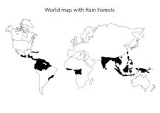
World Map With Rain Forests
In this geography worksheet, students study a map of the world which shows shaded areas indicating where the rain forests are located. There are no labels for countries or continents.
Curated OER
Oprah Winfrey Opens New School in Africa
Students locate Africa and share their knowledge of the continent, then read a news article about Oprah Winfrey building a school in South Africa. In this current events lesson, the teacher introduces the article with a discussion and...
Curated OER
How Has Colonialism Led to Multilingualism in Africa
Prepare yourself for a top-notch presentation on colonialism in Africa! Discussed are the reasons for African multilingualism. Maps and a country-by-country look at various colonists that made their mark on the African continent are...
MENSA Education & Research Foundation
Connecting Africa: A Project-Based Learning Adventure
Mission Possible: Your task is to design a new highway route from Tunis, Tunisia to Cape Town, South Africa. If you accept the challenge, you must create a small map of the route that has already been rejected, a rationale for rejection...
California Polytechnic State University
Australian Geography Unit
At the heart of this resource is a beautifully detailed PowerPoint presentation (provided in PDF form) on the overall physical geography of Australia, basic facts about the country, Aboriginal history, and Australia culture and lifestyle.
Curated OER
Me on the Map Lesson 1
Students use maps, globes, geographic information systems and other
sources of information to analyze the nature of places at a variety of scales. They identify on a map and determine the population
of the city, county, state, country...
Curated OER
World Map and Globe
Students locate and identify continents and countries. In this world map lesson, students locate and identify one country on each continent.
Curated OER
Where In the World Am I?
Learners identify their location in the world after studying latitude, longitude, relative location, and absolute location. They use assigned web site to find information to make a flipbook that answers questions about their location in...
Curated OER
Treasures of Egypt
Learners match pictures of Egyptian culture with their descriptions. They assemble a poster of resources about Egypt.
Curated OER
Geography A to Z: All Around Europe #3
The Leaning Tower of Pisa, The Colosseum, and the country where the Kremlin is located are a few of the clues learners will use to determine the names of five world locations. The first letter of each mystery location is provided, but...
Curated OER
Tracing Our Own Family Pilgrimages
The Pilgrims may have arrived in North America by way of the Mayflower, but chances are, your class members' ancestors came to the United States in another way. Guide them through an exploration of their own heritage, countries of...
Polar Bears International
Top of the World
Learn about polar bears and the Arctic circle with a lesson about the countries and conditions of the region. After examining how the area differs from Antarctica, kids explore climates, animals, and geographical position of countries in...
Curated OER
How were European nations capable of dominating the African contintnt?
Help your class determine why European was able to dominate the African continent. They read 5 excerpts, each related to a reason why Europe colonized Africa. Then they answer 4 critical-thinking questions.
National Geographic
Australia, Antarctica, and Oceana
Go on a traveling adventure throughout Australia, Oceana, and Antarctica! This textbook excerpt offers a full unit of study that can easily be supplemented by extra projects or research materials. Learners study maps, read about native...
Curated OER
"Wedding Celebrations Around The World"
Ninth graders research the cultural implications of wedding celebrations around the world. They study wedding celebrations before creating world map on which they place an appropriately attired wedding couple on the country they studied....
Pulitzer Center
Food Insecurity
Food insecurity, whether as a result of food scarcity or a lack of nutritious food, is a growing and serious problem in the world today. After discussing the concept of food insecurity, learners listen to an NPR radio broadcast on the...
American Chemical Society
Joseph Priestley, Discoverer of Oxygen
Do you want to hear a joke about nitrogen and oxygen? NO. We all know there is oxygen in the air and that plants produce oxygen, but how was it discovered? Scholars read a handout, answer questions, and analyze material in the...
Curated OER
Land of the Rising Sun
Students survey aspects of traditional and modern Japanese customs and beliefs in the seven lessons of this unit. Both the culture and the geography of the country are studied in this unit.
Curated OER
Introduction to African Folklore
Young scholars are read "Anansi the Spider" to begin their discussion on continents. Using a map, they locate the continent of Africa and the country of Ghana. They discover who the Ashanti people are and view examples of their artwork....
Curated OER
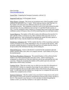
Comparing the European Community with the U.S.
Learners research a country to compare with the U.S. In this compare/contrast lesson, students research the CIA World Factbook research a European country's characteristics. Learners calculate growth rate and doubling time and examine...
Curated OER
Trip Planner WebQuest
Fifth graders are introduced to research and realism to raise their level of excitement and involvement. They focus on a foreign country. Students are allowed to select the country they want to visit and research. They are encouraged...
Curated OER
Mapping China
Students identify cities in China on a map. In this map skills lesson, students locate the continent of Asia and the country of China. Students use a blank map to label China and bordering countries.


