Curated OER
Charles Lawrence's Expulsion Orders or Acadians in 1755
An interesting, but sparse, PowerPoint on early North American history awaits your class. The presentation is only two slides. It is a copy of a letter written by Charles Lawrence to Major Hanfield commanding him to clearing the country...
Curated OER
Middle East Quiz
In this geography skills quiz learning exercise, students take 1 of the 3 provided outline map quizzes on the 23 Middle Eastern countries. Three separate quizzes are offered.
International Technology Education Association
Become a Weather Wizard
Accurate weather forecasting is something we take for granted today, making it easy to forget how complex it can be to predict the weather. Learn more about the terms and symbols used to forecast the weather with an earth science lesson...
Curated OER
Getting to Know My World
Students participate in hands-on activities using maps and globes to identify geographical features. Students use map legends to identify direction. Students locate oceans, continents, countries, states and cities. Handouts and...
Curated OER
South American Outline Map
In this blank outline map worksheet, students study the political boundaries of the continent of North America and those of the countries located there.
Curated OER
Africa Outline Map: Labeled
In this Africa outline map instructional activity, students explore the political boundaries of the continent of Africa the countries located there. Each of the nations is labeled on the map.
Curated OER
Rapping Regions in America
Young scholars determine what designates a place as a region. They apply their criteria for a region to the US map. They work in groups to write a rap about their region that describes its organization, type and structure.
Curated OER
Regions of South America
Students explore facts about South America in the four lessons of this unit. Booklets are created from the materials produced as the class delves into the topic.
Curated OER
African Safari
Sixth graders gain an appreciation for the different cultures that inhabit the Earth by focusing on the people of Africa
Curated OER
Asia Outline Map
In this Asia outline map worksheet, students explore the continent as they label the 47 countries. The countries are numbered and lines for the answers are provided on the sheet.
Curated OER
Middle East Related
Eighth graders find a current event related to the Middle East. In this current event lesson students write a brief summary of a new story related to the Middle East. They give their opinion and tell how it affects their life or who it...
Curated OER
Island Countries
Students define the meaning of an island. In this island mapping lesson, students identify islands on the map. Students discuss the sizes of various islands.
Curated OER
Geography Words
This learning exercise uses maps of South America and Canada to combine basic geography vocabulary and using prepositions. Students use the maps to answer questions about the locations of various countries on the two maps. This would be...
Curated OER
Labeling the World
Sixth graders conduct research on the countries found on the labels on their clothing. They locate the countries on a map, research the labor practices on countries that export clothing to the U.S., and create a graph using the information.
Curated OER
Where in the World is Egypt?
In this geography worksheet, students investigate the location of the continent of Africa and the country of Egypt by studying a map of the region. Students color the map and locate Egypt.
Curated OER
Australia: the Land Down Under
Students give a solid history and geographic explanation of the country of Australia and explain why it is important. They use some creativity in designing their own island, by using the physical features of this particular country.
Curated OER
Introduction to Africa
Students are introduced to Africa. The purpose of this lesson is to find out what students all ready know about the continent of Africa, and what students are interested in learning more about. They focus on the physical features of Africa.
Curated OER
Australia
First graders are introduced to the country of Australia through books, Internet research, maps and music. They listen to stories, watch videos, decorate cookies and participate in an Australian-themed day of activities.
Curated OER
African Safari Adventure
Students conduct Internet research on the different safaris available. They locate and label safari sites on the continent of Africa. They create a PowerPoint presentation for the class to persuade the class why they should vote for...
Curated OER
Foods and Languages of the World
Students celebrate diversity. In this multicultural appreciation lesson, students celebrate diversity by sampling food from different cultures, learning a few words in Spanish and identifying the seven different continents.
Curated OER
The borders of Europe. Geographically location or cultural artifice?
Twelfth graders discuss where they regard the boundaries of Europe to be. They raise their awareness that "Europe" may be more of a cultural construct than geographical defined continent.
Curated OER
North America Puzzle Answer Sheet
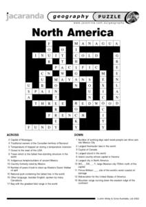
In this geography worksheet, students name the capitals of various countries found in North America. They also identify the various weather patterns across the continent and specific bodies of water. There are 21 descriptions and 21...
Curated OER
Learning About Maps
Students investigate the many uses and features of maps and globes and locate where they live on both. In this map lesson, student play a travel game and create their own maps to explore states, continents, countries, and islands.
Curated OER
Mexico: One Land, Many Cultures
Students research and study the country of Mexico and complete a project about it. In this Mexico lesson plan, students research Mexico's geography, traditions, art, songs, stories, and legends that are native to Mexico.


