Curated OER
Holocaust
Seventh graders explore the geography of Eastern and Western Europe. They compare and constrast the culture of Jewish people from Eastern and Western Europe. They analyze deportation and confinement in concentration camps, using personal...
Curated OER
Exploring Islamic Lands
High schoolers examine the lives of Islamic teens. In this global studies lesson, students explore selected Internet sites to discover the attributes of Islam, the cultural traditions of Islam, and information regarding Middle Eastern...
Curated OER
Walk in My Shoes
Students discover how culture, geography and history affect how someone views an area of the world. They role play the role of a Palestinian, Jew or Briton and examine how they felt about Israel during its formation. To end the lesson...
Curated OER
Going into the Great North
Students observe and investigate the areas included in the Great North. In this geography lesson plan, students observe a documentary based on the Great North. Later the students will draw and identify countries within the arctic circle...
Curated OER
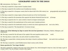
GEOGRAPHY GOES TO THE DOGS
Young scholars use countries and dogs from around the world to answer the questions.
Curated OER
Mapmakers' Perspective
Pupils examine several maps and consider mapmakers' perspective in early depictions of North America.They determine how the spherical shape of the earth makes any north-south and east-west orientation a matter of perspective. For...
Curated OER
Continents and Oceans
In this geography worksheet, students read a paragraph and learn about the seven continents and five oceans of the world. Students study a map of the world and answer 12 short answer questions. This is an online interactive worksheet.
Curated OER
British Colonization-Settling the Thirteen Colonies (1607-1733)
Young scholars study the thirteen colonies: geography, economics, politics, and religious groups. They explore early colonial life, and create a travel brochure, travel guide of the 13 Colonies, and word search.
Curated OER
Capturing the Reader With Vivid Images
Students examine the use of imagery to hold a reader's attention in an excerpt from John Deever's memoir "Mr. John and the Day of Knowledge". They are introduced to background information about the Ukraine and create original imagery.
Curated OER
Whoa! Slow Down-Some of You!
High schoolers analyze demographic data (growth rate, natural increase, fertility rate, crude birth rates, and crude death rates) and determine which areas of the world contain the fastest and slowest growth rates. They construct...
Curated OER
Capturing the Reader with Vivid Images
In this using vivid images worksheet, pupils identify vivid images and analyze their effectiveness in John Deever's "Mr. John and the Day of Knowledge." Students then write rich images for their classmates to imagine.
Curated OER
World Hunger - A Cultural Crisis
Students explore the problem of world hunger and starvation. After a class discussion, students use a map to identify specific areas where populations are starving. In groups, students research reasons for the lack of food. They prepare...
Curated OER
THE TWO HEMISPHERES SHARE!
Students analyze the positive effects of Columbus' journey to the Americas and the impact on their lives today of the meeting of the two hemispheres.
Curated OER
World Religions
Ninth graders investigate the symbols and historical figures of the five main religions of the world. They participate in a class discussion, listen to a lecture and take notes, and write five Haikus, one about each major religion of...
Curated OER
The Importance of Speaking Another Language
Students evaluate how important it can be to speak a language other than their own.
They analyze the role language plays in bridging cultural differences and compare their reasons and see if the class can reach a consensus on the...
Curated OER
* Educators * Lesson Plans The Importance of Speaking Another Language
Pupils examine the importance of speaking more than one language. They read and discuss an account written by a Peace Corps teacher in Ukraine, answer discussion questions, and discuss why English is taught in Ukraine.
Curated OER
A Tale of Two Frogs
Second graders locate Russia on a map or globe and work in pairs to complete the Map worksheet. They read the book, A Tale of Two Frogs stopping after page 15. They write an ending to the story and then read more of the book stopping...
Curated OER
Let's Spice It With Pepper
Students identify and locate the areas in which pepper and spices orginated. On a map, they locate the areas and write the name of the spice that is found there. They use historical events to trace its route to the Americas. They...
Curated OER
What's So Great About Peter?
Young scholars research the origins of the name of their town or city. They pick another city and do the same, individually. They also write a bio poem about a historical figure.
Curated OER
Traveling the Silk Road
Students take a virtual trip down the Silk Road. Using a map, they trace the location of the trade route and others that were developed later. They use different spices and goods to trace how they came to the Americas. They answer...
Curated OER
How to Celebrate the 800th Anniversary of the Mogol Empire
Learners research information on the Mongolian Empire from various readings and online videos of primary sources and create a poster for oral presentation. Students connect history with the current day, while incorporating geographical,...
Curated OER
Old World and New World - Why Contact Took So Long
Students use a globe to determine why contact between the old world and the new world took a long time. In this map skills lesson, students analyze routes between regions to determine why it took so long for the old world and the new...
Lizard Point Quizzes
Lizard Point: Europe: Countries Quiz
Try this interactive geography quiz which tests your knowledge about the countries of Europe.
University of Texas at Austin
Perry Castaneda Library Map Collection: Historical Maps of Europe
This collection from the University of Texas Library Online of historical maps contains a wide variety of maps from various parts of Europe and from different parts of history. Each map is accompanied by a brief description and is clear...


