Syracuse University
Erie Canal
While canals are not the way to travel today, in the first half of the nineteenth century, they were sometimes the best way to move goods and people. Scholars examine primary sources, including maps and pictures, to investigate the role...
Curated OER
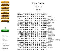
Erie Canal
In this social studies, students find the words that are related to the location of the Erie Canal. The answers are found by clicking the button at the bottom of the page.
Curated OER
Ohio and Erie Canal
Learners use maps, readings and photos to research the construction and effects of the Ohio and Erie Canals. They compare the region's economy before and after the canal's construction and analyze transportation routes in their own...
Curated OER
Finding Your Way Around the I & M Canal
Fifth graders utilize a map of the I&M Canal (imbedded in this plan), and perform a series of tasks. They calculate distance, find specific points of interest and solve a set of story problems about the canal.
Curated OER
Transportation Systems: Two Liter Boat Activity
Students design and build full-size boats made out of two-liter plastic bottles, chicken wire, and plywood. Then they race the boats, with the boat's designers "manning the hull", in the school's swimming pool.
Curated OER
Iced In
Introduce junior oceanographers to ice conditions in The Great Lakes. The ice map links are no longer available, so you will not be able to have your class perform the mentioned data activity. You can, however, access the Canadian Ice...
Other
New York State Canals: Erie Canal Map
This site has a map of the Erie Canal and lets you zoom in on different parts of the Canal to view where the locks are.


