abcteach
Street Mapping
What's around the block? Or down the street? Ask your pupils to tap into their map skills by drafting the area around their home and school.
Curated OER
Getting to Know Austria- Map Skills
In this Austria map skills worksheet, students apply map skills to answer 14 fill in the blank questions about the country. They determine border countries, identify regions, find the capitol, and name rivers. They draw a map of Austria...
Curated OER
Map Skills
Students create two types of maps. In this map skills lesson, students discuss map vocabulary and view maps of Florida. Students draw a free hand map of Florida and include major cities, bodies of water and land forms. ...
Curated OER
Getting to Know France
In this map skills worksheet, students answer 14 questions about the geography of France. Students then draw a rough map of France. It is assumed that access to an atlas is available.
Curated OER
An Archaeological Adventure in Athens
Students review map skills and practice finding locations on a map. In groups, they create maps with mystery locations identified by hidden stick-on magnets. Other groups attempt to find the mystery locations and then check their work...
Virginia Repertory Theatre
The Town Mouse and the Country Mouse
Accompany the story, Town Mouse Country Mouse by Jan Brett with an assortment of activities designed to reinforce concepts covering story structure, comprehension, grammar, and social studies. Here, scholars identify the difference...
Curated OER
Mapping Mistakes
Students examine early European maps and explore geographic errors. They also view maps of the geography of North America. Students discuss the obstacles faced by early explorers in mapping unexplored territory. They consider what the...
Curated OER
Our World With MapsQ
Young scholars examine and compare different types of maps. In this map skill lesson plan, students look at neighborhood and national maps on the overhead projector while making comparisons of the symbols and locations. They use a...
Curated OER
United States: Physical Features Fun
In this map worksheet, students color and trace eleven listed features on a map of the United States. Students answer six additional questions about the map. A United States map is not provided. However, websites are provided to find...
Curated OER
Getting To Know Germany
In this getting to know Germany worksheet, students use map skills (map not included) to answer 14 questions, then draw a map of Germany labeling the capital and major cities.
Curated OER
Sub-Saharan Maps
In this geography skills worksheet, students draw real or imaginary maps that feature escarpment, rift valleys, gorges, diamond mines, plateaus, mountains, lakes, rivers, and gold mines.
Tennessee State Museum
An Emancipation Proclamation Map Lesson
Did the Emancipation Proclamation free all slaves during the Civil War? Why was it written, and what were its immediate and long-term effects? After reading primary source materials, constructing political maps representing information...
Curated OER
The Underground Railroad
Students explore the Underground Railroad routes. In this map skills and Civil War instructional activity, students use map and globe reading vocabulary and skills to track the routes the slaves followed from the Bahamas to the United...
Curated OER
In Mr. Lincoln's Shoes
Students demonstrate basic map skills. In this US history lesson, students review cardinal directions and use a compass rose while at the same time discuss what life was like for Abraham Lincoln.
Curated OER
Geography of South America
Young explorers study South American geography. They study maps and create a physical map of the Andes themselves! They also research the geography, environment, and the culture of the Andes and present a report to the class.
Baylor College
Mapping the Spread of HIV/AIDS
Where is HIV/AIDS most prevalent and what are the current trends regarding HIV? Have groups work together to map the world's HIV/AIDS rates, then create a class map with all the data. Lesson includes cross-disciplinary concepts including...
Curated OER
A Visit to Hogwarts
Students collaborate in groups to read excerpts or entire selections from two Harry Potter books, use educational software to create concept maps detailing similarities and differences between first two Harry Potter books, and analyze...
Curated OER
Gopher It! Exploring German Cyberspace
Students are introduced to the Gopher research tools. In groups, they compare and contrast English and German services on the gopher servers. They create their own dictionary of computer related terms and spend time downloading picture...
Curated OER
Mapping South America
Students explore South America. In this South American instructional activity, students use their geography skills to create population, terrain, biomes/vegetation, and major exports maps. Students present their finished maps to their...
Curated OER
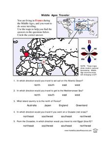
Middle Ages Traveler
In these Middle Ages worksheets, students use the maps to help them find the answers to the questions that help them understand the directions of north, south, east and west. Students also color another map of France according the...
Curated OER
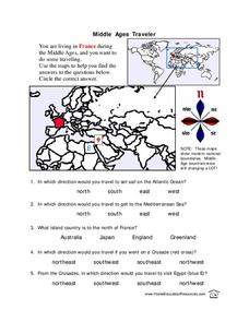
Middle Ages Traveler
In this map worksheet, students are given three maps of France to use to answer multiple choice questions. Students complete an activity from the perspective of a Middle Ages traveler.
Center for History and New Media
Slavery and Free Negroes, 1800 to 1860
What was life like for enslaved and free black people before the American Civil War? Explore the building tension between states and the freedom of individuals with a thorough social studies lesson. Learners of all ages explore...
Curated OER
Are Butterflies Free?
Students use remote sensing to study monarch butterfly migration and human interaction to save the Oyamel forest (Mexico) for butterfly and human habitation.
Curated OER
States/Capitals L-N: Matching
For this geography practice worksheet, students match the 17 listed states to the appropriate 17 listed capital cities located in the United States.


