Teach Engineering
What is GIS?
Is GIS the real manifestation of Harry Potter's Marauders Map? Introduce your class to the history of geographic information systems (GIS), the technology that allows for easy use of spatial information, with a resource that teaches...
Curated OER
Map It!
Fourth graders demonstrate map making skills by using the computer to create maps of the geographic features, regions, and economy for their state.
Curated OER
Map Lesson Plan
Fourth graders locate and label major sites related to the Revolutionary War in the Hudson River Valley. They examine topographical features of each site and list a few of these features and list two advantages of each military site.
Curated OER
Play Doh Map of Your State
Students create a state map using Playdoh. For this hands-on state geography lesson, students work in groups to form a three-dimensional map of their state using Playdoh made at home following a (given) recipe. Students use four...
Curated OER
What You Can Learn From a Map
Students discover how to interpret maps. In this geography skills lesson plan, students explore geographic themes as they complete worksheet activities regarding road maps, shaded relief maps, and topographic maps.
Curated OER
Geography And The Revolutionary War
Students gain a deeper understanding of both geography and the Revolutionary War. They practice using on line research in examining historical events and using political, physical, and topographic maps.
Curated OER
Orienteering Lessons - Overview
Welcome to the Orienteering lesson plans page. There is a short introduction to the topic and links to the ten lessons in this unit. There is also a linkto the unit home page. This orienteering unit is worth taking a look at.
Curated OER
Take a Hike
In this geography skills instructional activity, students respond to 9 questions that require them to read topographic maps and interpret them. The topographic maps are not included.
Curated OER
Waldseemuller's Map: World 1507
Learners investigate the 1507 word map. For this world geography lesson, students examine the details of each section of the map and then draw conclusions about how the people of 1507 understood the world. Learners are evalated on...
Curated OER
Geography of the Harbor
Students study estuaries and their boundaries. In this investigative instructional activity students locate an estuary on a map and use nautical and topographical maps.
Curated OER
Waldseemüller’s Map: World 1507
Young scholars take a closer look at historical maps. In this primary source analysis instructional activity, students examine the first world map produced by Martin Waldseemuller. Young scholars complete the included map analysis...
Curated OER
Map It With Pixie
Fourth graders use the computer program 'Pixie' to create a topographic, detailed map for the state they live in. In this mapping skills lesson, 4th graders use Pixie to make a map of their state that includes topographic features, state...
Curated OER
Boundaries and People
Students map watersheds to find their boundaries. In this watershed activity students map and then give their "watershed address." Students show the trail from stream, larger stream to oceans. Students describe the...
DocsTeach
Lewis and Clark's Expedition to the Complex West
Lewis and Clark's famous expedition is a prime example of the United States' westward expansion. Aspiring historians examine maps from Lewis and Clark's journey, as well as discuss their interactions with Native American tribes. The...
Smithsonian Institution
Borders with the World: Mexican-American War and U.S. Southern Borderlands
The Mexican-American War created social borders—not just physical ones. Scholars learn about the effects of the Mexican-American War on the people living in the borderlands using text excerpts, maps, and partnered activities. Academics...
Curated OER
U.S. Geography- The Northeast
Students investigate the geography of the Northeast states. In this map skills lesson, students are shown a map of the Northeast states and identify the state names and borders. Students construct individual maps of the Northeast using...
Curated OER
You Are Here
Students map local places and learn to use scale and distance. In this mapping lesson plan, students map their school and a favorite place. Students recreate their maps showing distance and scale sizes. Students locate their...
Midnight Martian
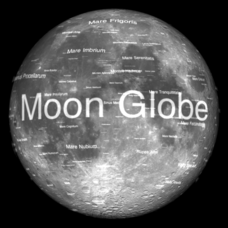
Moon Globe
Not just a simple globe of the moon, this interactive version allows you to choose lighting according to the location of the sun, views from different positions on Earth, and more! Satellite images and topographic data have been combined...
Curated OER
Mountains
An informative and well-designed presentation on mountains awaits your geographers. Excellent photographs from mountain ranges around the world are includedin this terrific PowerPoint. The last slide effectively sums up what pupils have...
Curated OER
Planning a Railroad
Young scholars use a topographical map to plan a route from Doknner Summit to Truckee, then compare it to the route selected by Theodore Judah.
Curated OER
What do Maps Show?
Seventh graders practice reading maps. In this geography lesson, 7th graders compare a topographical map to a picture of the actual place.
Curated OER
The Landscape of a Novel
Students, after reading a novel, utilize geographic skills to map out the places described in the novel. They collect data, envision spatial features and then design a map to work off of to complete their assignment. Each student also...
Curated OER
Nature and Place Names in Arkansas
Middle schoolers examine the way that many place names in Arkansas came to be. By looking at Arkansas highway maps, they find names that come from the characteristics of each of the state's six geographical divisions. This interesting...
Curated OER
Natural Resources
Young scholars explore Iowa geography and topographic maps. In this geography and topographic maps lesson, student investigate maps, newspapers, Iowa flora and fauna. Students gain an understanding of how different landforms can be...


