Curated OER
Characteristics of Africa
Students describe basic land features and characteristics that make up the continent of Africa, describe the people of Africa, where they live, and how they live and get a sense of what it is like to live in Africa.
Curated OER
Investigating Our Place in the World
Students study the concept of geography in a year long unit. In this geography unit, students participate in different activities that explain the spatial sense of the world, the physical landmasses and bodies of water, geographic...
Curated OER
The Dawn of Humanity
Students investigate recent archaeological challenges to theories of human origins. They research the history and geography of various African regions to create proposals for future excavations.
Curated OER
What is Kwanzaa?
Describe the general characteristics of Kwanzaa after reading Seven Candles of Kwanzaa. For this Kwanzaa lesson, learners study the principles of the Kwanzaa holiday and interpret the principles through music and dance. They...
Curated OER
THE TRAVELS OF BABAR: An Adventure in Scales
Students locate and identify the seven continents. They use longitude and latitude in establishing a location. Students enhance the knowledge of geographical location with cultures. Individuals or small groups research multiple aspects...
Curated OER
Mapping West Virginia
Fourth graders explore West Virginia. In this Unites States geography lesson, 4th graders discuss the type of land and the cities in West Virginia. Students create two overlays, with transparencies, that show the natural land and the...
Curated OER
Maps that Teach
Students study maps to locate the states and capital on the US map. Students locate continents, major world physical features and historical monuments. Students locate the provinces and territories of Canada.
Curated OER
Learning About Our World
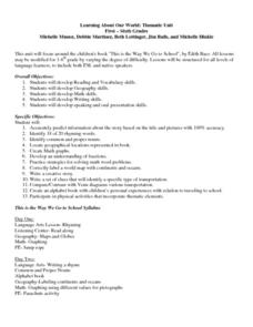
Learners explore their world using the book "This is the Way We Go to School." They predict information about the story based on the title and pictures. Students label a world map with the names of continents and oceans. They write a set...
Curated OER
The Mausoleum at Halicarnassus
Students explore an ancient wonder of the world. In this Mausoleum at Halicarnassus lesson, students read about the history of the Mausoleum, create Mausoleum timelines, and research the sculptors whose work is featured in the Mausoleum.
Curated OER
The Great Lighthouse at Alexandria
Students read and research about Alexandria's Great Lighthouse. In this Greek architecture activity, students create a timeline of events in Alexandria, and design a lighthouse. Students research lighthouses online and write a report.
Curated OER
Antarctica
Third graders become familiar with Antarctica, the Earth's southernmost continent, by researching its environment and inhabitants. They reference maps, conduct Internet research, identify animals, create graphs and write reports.
Curated OER
Where In the World Are You?
Fourth graders fill in blank copies of the United States Map and then the World Map.
Curated OER
The Dynamic Earth
Young scholars participate in assessments related to the layers of the Earth. They read chapters of text, answer questions, watch videos, and identify and label continents and oceans on a map. They design posters, create vocabulary...
Curated OER
Put Me in My Place: Using Alphanumeric Grids to Locate Places
Students practice locating points on a large wall grid and create and label a neighborhood map. For this geography lesson, students spell and discuss places as the teacher places them on the map. They discuss the concept of an...
Curated OER
If These Walls Could Talk: Seeing a Culture Through Human Features
Students read Talking Walls and discuss the walls presented and their importance to the culture. In this geography lesson, students locate and label each country/continent discussed in the book on a world map. Students take a walk and...
Curated OER
Mapping Community Values
Students discuss the origin of various maps focusing on the values behind them. Students also explore how human needs and geography influence community settlement patterns. Students extend learning by creating and mapping their own ideal...
Curated OER
Literature
Students listen and respond to poems about rain. Then they review the continent of Asia and the country of Japan. They listen to a Japanese folktale about a peach boy. Next they listen to a story from Germany about musicians.
T. Smith Publishing
48 Contiguous States
What do your pupils know about the United States? This resource asks learners to respond to 10 questions about certain states and landmarks. Useful for a geography lesson and to help familiarize your learners with the continent. An...
Curated OER
Mapping Africa
Students identify the location of parallel and meridian coordinates. They illustrate their understanding of the physical shape of the continent of Africa through a mapping activity, then explain the processes that have influenced the...
Curated OER
The borders of Europe. Geographically location or cultural artifice?
Twelfth graders discuss where they regard the boundaries of Europe to be. They raise their awareness that "Europe" may be more of a cultural construct than geographical defined continent.
Curated OER
The Interconnectedness of Ancient Peoples Map Study
Seventh graders begin this lesson by viewing various maps of the Ancient World. As a class, they take notes on the changes of different areas in Europe and Asia as their teacher lectures to them. They answer questions about the...
Curated OER
North America Puzzle Answer Sheet
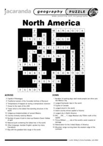
In this geography worksheet, students name the capitals of various countries found in North America. They also identify the various weather patterns across the continent and specific bodies of water. There are 21 descriptions and 21...
Curated OER
Globe Lesson 17 - Alaska and Hawaii - Grade 4-5
Students develop their globe skills. In this geography skills lesson, students explore the area added to the United States when the Alaskan territory was purchased from Russia.
Curated OER
Asia Crossword
In this geography worksheet, students complete a crossword puzzle on the continent of Asia. They answer 21 questions related to the type of government systems found, capital cities, deepest lake, and lowest population density.


