Curated OER
European Language Groups, 1850
Document the linguistic diversity and major language groups common to Europe in 1850. A map and a list of regions, countries, and water ways is provided.
Curated OER
Eastern Europe in 1989
Major political shifts occurred in Eastern Europe during the late 1980s. Locate, identify, and label 90 different areas on the provided map. A list of cities, countries, and water ways is provided.
Curated OER
Choropleth Mapping Skills
In this geography instructional activity, students identify and describe how to apply choropleth mapping skills. They examine the map given and convert it into a choropleth map through coloring. Then students use those colors to shade in...
Curated OER
Australian Geography
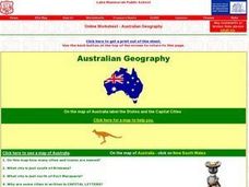
In this map reading instructional activity, students label a map of Australia by adding the names of states and cities. They answer eight questions about the map.
Curated OER
Geography Tutor: Maps and Map Projections Questions
In this geography skills lesson, students watch a video titled "The Geography Tutor," and then respond to 14 short answer questions about maps and map projections.
Curated OER
Map Work: How Far?
In this map scale worksheet, students analyze a map of an area with several towns marked. Students use the scale (1 cm = 1 km) to answer 6 questions about the distances between towns.
Curated OER
Geography Worksheet
In this geography skills worksheet, learners respond to 14 short answer questions by using maps and atlases. The maps and atlases are not included.
Curated OER
Middle East Geography Worksheet
In this geography skills worksheet, students examine the provided map of the Middle East, identify the noted countries, and write facts about each of the countries.
Curated OER
Topographic Maps Worksheet
In this geography skills learning exercise, students respond to 37 multi-part questions that require them to read and interpret topographic maps.
Curated OER
Japan's Geography Worksheet
In this geography skills worksheet, students label a map of Japan and then respond to 8 short answer questions about the country.
Curated OER
Map Skills
In this history worksheet, students use a map and legend to answer nine comprehension questions. Students check their answers when done.
Curated OER
Map Skills
In this history worksheet, students utilize a map and legend to answer eleven comprehension questions. Students check their answers when done.
Curated OER
Sub-Saharan Maps
For this geography skills worksheet, students draw real or imaginary maps that feature escarpment, rift valleys, gorges, diamond mines, plateaus, mountains, lakes, rivers, and gold mines.
It's About Time
The Changing Geography of Your Community
Lead your class in exploring their local communities as well as the general environment. As they determine continental distributions by investigating minerals, rocks, and fossils located in their local region, pupils construct...
Curated OER
U.S. Geography for Children: Michigan
In this Michigan map activities activity, students observe an outline map of the state of Michigan, locate and label specific places and areas, and create a map key. Students complete 5 activities.
Curated OER
U.S. Geography for Children
In this U.S. map activity worksheet, students observe maps of the continental United States, Hawaii, and Alaska, locate and label landforms and bodies of water, and create symbols for natural resources and places of interest. Students...
Scholastic
Volleyball Road Trip
Review coordinate mapping with your young geographers by matching cities on a volleyball team's road trip itinerary to their appropriate coordinate locations.
Geophysical Institute
Latitude and Longitude with Google Earth
Travel the world from the comfort of your classroom with a instructional activity that features Google Earth. High schoolers follow a series of steps to locate places all over the earth with sets of coordinates. Additionally, they...
Gymnázium Karviná
Australia and New Zealand
Send your learners off on a research adventure with a worksheet on essential facts about Australia and New Zealand. It includes 18 short-answer response questions, as well as a map activity where pupils locate a variety of...
Curated OER
States/Capitals L-N: Matching
In this geography practice worksheet, students match the 17 listed states to the appropriate 17 listed capital cities located in the United States.
Curated OER
The Roman Empire-Map Activity
In this Roman Empire worksheet, students complete a map activity in which they label and color civilizations, countries and physical features as instructed. There are no maps included.
Curated OER
The Expansion of Islam to 750
Track the expansion of Islam throughout the Mediterranean and Near East. Locate and label 17 different areas that adopted the tenets of Islam.
Curated OER
BOLTSS Map
In this geography worksheet, students identify the six features always used on maps. They identify each of these features by the acronym BOLTSS. Students examine the Melbourne Cricket Ground shown and respond to the 4 questions that follow.
Curated OER
Geographical Skills-- Map Scale
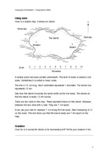
In this maps worksheet, students study a simple map and the scale in kilometres. Students read the directions and answer one question. Students then look at a sketch map of a town and answer 2 questions. Students also read how to show...
Other popular searches
- Geography Map Skills Scale
- Geography Map Skills Europe
- Usa Geography Map Skills
- Geography Map Skills Us
- Canada Geography Map Skills
- Map Skills Geography Themes
- Geography Map Skills Ohio
- Map Skills Geography


