Curated OER
Eye on the Storm
Students discover the way geologists collect information about past hurricanes to determine patterns that may help with storm prediction. They then research the history of natural disasters in different regions of the United States and...
Curated OER
Dangerous Air
Students investigate how pollution is a global issue. They locate the countries affected by radiation from Chernobyl, sequence the progress of radiation transport from Chernobyl and plot the pollution points on a world map, and read and...
Curated OER
Mapping West Virginia
Fourth graders explore West Virginia. In this Unites States geography lesson, 4th graders discuss the type of land and the cities in West Virginia. Students create two overlays, with transparencies, that show the natural land and the...
Curated OER
Around the World
Students discuss the major geographical and cultural differences in the world. In this social science lesson, students pretend they are traveling and research information about where they wish to stay by finding information about the...
Peace Corps
Starting Off the Day (and School Year) in Ukraine
Students compare the first day of school in Ukraine with the first day of school in the United States, including the challenges students and teachers both face in each country. They respond in class, in their journals, to the following...
Curated OER
Diversity
Young scholars work in groups to research and prepare an oral report about a region. In this regions lesson, students find out about the geography, population, state capitals, and landmarks. Young scholars assign attributes...
Curated OER
Conflict Transformation
Students analyze the usefulness of conflict. In this conflict resolution lesson, students will examine several real life conflict scenarios. Students will analyze these conflicts in terms of there costs and benefits to determine weather...
Curated OER
Chapter 3 Test: The Southeast States
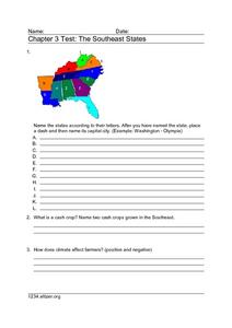
In this geography worksheet, students complete a test about the southeastern United States. They name the states, tell about the climate and crops, complete a matching activity about the landforms. and another about the industry.
Curated OER
Around the World
Students explore ways people from around the world are like them. They discuss how geography affects the way people live and work and how culture affects a person's day to day life. Students give a presentation over a chosen country to...
Curated OER
Papier-Mâché Globe
Paper mache projects are great for using up paper from the recycle bin. Give your class the chance to create a three-dimensional globe out of paper mache. They'll work to make their globes as accurate as possible, adding proper colors...
National Park Service
Living & Non-Living Interactions
What better way to learn about ecosystems than by getting outside and observing them first hand? Accompanying a field trip to a local park or outdoor space, this series of collaborative activities engages children in...
Curated OER
Spanish/American Comparison
Students compare Spanish and American cultures. In this global studies instructional activity, students review what they have learned in a Spanish culture unit by writing compare and contrast essays about Spanish and American cultural...
Curated OER
What Causes Irregular Temperature Patterns?
Students examine common trends in climate across the U.S. They identify the anomalies in hot-cold temperature differences in the U.S and locate them on the map using latitude and longitude coordinates.
Curated OER
Shore is Windy!
Pupils consider what a hurricane is and how it impacts both land and people, explore the speculations surrounding Hurricane Isabel, research potential target sites and create maps illustrating how Isabel may affect them.
Curated OER
Land and Environment Affected Settlement
Learners analyze the physical characteristics of different regions of the United States and how these physical characteristics affected settlements across the States.
Curated OER
Comparing Temperature, Pressure, and Humidity
Young scholars investigate data on temperature, pressure, and humidity by downloading information from the ARM Website. Working in groups, they discover how weather impacts life in each of the ARM sites. They record weather data in their...
Curated OER
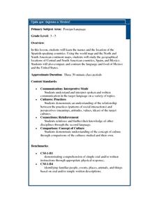
Ojala que viajemos a Mexico!
Students research the names and locations of Spanish speaking countries throughout the world. They use a world map to become familiar with the locations of these countries and use the Internet to conduct further research. They sing...
Curated OER
The Water Around Us
Students discuss importance of reading maps and knowing about the geography of the United States, and locate bodies of water on different types of maps and examine how they are used in the state or local community.
Curated OER
Africa's Climatic Regions
Learners are introduced to the different climates and vegetation of Africa, and compare them to similar climatic regions found in the United States.
Curated OER
Life in Sahara
Students explore the geography of the Sahara region of Africa and identify characteristics of a desert habitat. They explore the culture of the people living there and how it has adapted to desert life.
Curated OER
Exploring Virtual Europe
Students research the geography, government, climate, history, economy, and culture of a European country. They select a country in Europe, explore various websites, and complete a worksheet.
Curated OER
Cave Men to Cave Painting
Students explore the Ice Age. In this geology and social studies lesson, students read the book Eyewitness Books Early Humans and create a KWL chart about the Ice Age. Students locate Asia and North America on the World Map and...
Curated OER
Benjamin Franklin: Colonial Printer and Journalist
Fifth graders explore how important print media is to everyone's daily life. Students use present daily newspapers and they are to reproduce weather forecasts.
Curated OER
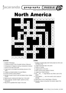
North America Puzzle Answer Sheet
In this geography learning exercise, students name the capitals of various countries found in North America. They also identify the various weather patterns across the continent and specific bodies of water. There are 21 descriptions and...


