Curated OER
You Are What You Eat (The 6 Main Nutrients Found in Foods)
Learners study how carbohydrates, proteins, fats, vitamins, minerals and water provide basic nutrients for body growth and function. They describe quality sources of the basic nutrients and the importance of water.
Curated OER
Europe Puzzle
In this geography worksheet, students complete a crossword puzzle in reference to the geography of Europe. They identify the capital cities of various countries and the bodies of water which surround specific countries of Europe.
Curated OER
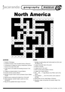
North America Puzzle Answer Sheet
For this geography worksheet, students name the capitals of various countries found in North America. They also identify the various weather patterns across the continent and specific bodies of water. There are 21 descriptions and 21...
Curated OER
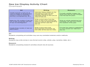
Displaying Sea Ice
Students display their knowledge of sea ice. In this earth science instructional activity, students create displays reflecting their understanding of sea ice.Students research the development of sea ice on a...
Curated OER
World Map Labels
In this geography skills worksheet, students identify the countries and bodies of water labelled on the maps of the world, Africa, Asia, Canada, Europe, the Caribbean, the Middle East, North America, Australia, and South America.
Curated OER
Basic Vitamins: Water-Soluble and Fat-Soluble
Students examine vitamins and study their functions and food sources. They research what happens to vitamins when foods are overcooked. They prepare a microwaveable vegetable quiche.
Curated OER
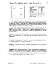
Identifying Materials by their Reflectivity
In this reflectivity worksheet, students read about the absorption and reflectivity of light by different materials. Students solve 4 problems and determine the composition of given materials based on the amount of light reflected. They...
Curated OER
Iraq, Where's That?
Students identify the Middle Eastern countries on the map and the oil-producing countries of OPEC in the region. They examine whether the presence of important producing oil fields qualifies as a characteristic of this region.
Curated OER
Geography of South America
Student's identify geographic features of a South American map. They use the scale of the map to calculate distances between points. They identify examples of the five geographic themes on the map of South America.
Port Jefferson School District
Climate Patterns
Young climatologists explore the factors that contribute to a region's climate in this two-part earth science activity. To begin, learners are provided with a map of an imaginary planet and are asked to label global wind and...
Curated OER
Building Bridges
Students identify the different types of bridges. Using the internet, they research information on how they are built by completing a scavenger hunt. Locating a specific area, they determine which type of bridge would be appropriate and...
Curated OER
Geography: Puerto Rico
Take a trip to Puerto Rico! Learners engage in a web quest, identify Puerto Rico on the map, and gather information related to physical features and cultural factors. Their efforts culminate when they design a brochure comparing the...
Curated OER
Water Quality and the St. Mary¿¿¿s River Project Monitoring
Students list different parameters of water and explain how each is important to the balance of the St. Mary ecosystem. They identify the different instruments and explain what they test.
Curated OER
Excretory System
Students discuss what happens to the trash in their home. They talk about what would happen if they didn't remove the trash. Students relate their home trash to the excretory system of their bodies. They label a diagram of the urinary...
Curated OER
Circulatory System Design
Students identify the different parts of the circulatory system and their function. They work together to create their own model of the system and use it to determine the rate of blood flow. They answer questions related to their model.
Curated OER
Your Digestive System
In this digestive system worksheet, 9th graders identify and explain any difference found in color of the mixtures in two glasses. Then they determine what enzyme was produced by glands in the mouth changing the starch in a chewed cracker.
Curated OER
Rivers that Flow from the Continental Divide: The Journey of Two Rivers
Students explore river routes. In this social studies lesson, students trace the route of a river from its source and discuss the Continental Divide. Students draw the route the river takes and name the states it flows through. Students...
Curated OER
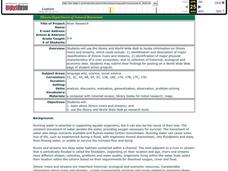
River Research
Pupils use the internet to research the streams and rivers found in Illinois. Using the information, they identify and describe the rivers and streams along with the physical characteristics of a river ecosystem. They share what they...
Curated OER
What Can I Do?
Students discuss feelings and ways to deal with problems. In this conflict resolution lesson, students identify their feelings and learn ways to resolve conflicts with others.
Curated OER
Calico Watercolor Cats
A fun art project, this lesson incorporates math and listening skills as young artists play with a new painting technique. First the teacher models how to draw a cat using shapes, an oval for the body, triangles for the ears and so on,...
Curated OER
What Do I Wear Out Here?
First graders identify the components of a modular spacesuit. In this astronaut clothing instructional activity, 1st graders discuss the importance of appropriate clothing for working in space. Students define the term...
Curated OER
Six Plant Parts
Learners create a harvest burrito out of fruit, flowers, roots, stems, and more. In this plants lesson plan, students go out into the garden and identify the 6 plant parts.
Curated OER
Oceanography
Second graders identify saltwater and freshwater habitats and the resources found in them. They compare and contrast the two habitats and discuss their findings. They discover the resources bodies of water can provide.
Curated OER
Interpreting Aerial Photographs
Students interpret aerial photographs. They view aerial photographs or satellite-produced images to locate and identify physical and human features. They study satellite images and label their images for bodies of water, clouds,...


