Curated OER
I Love the Mountains
First graders discuss and define different landforms. They read the book "Our Land", sing a landform song and perform it with motions and then complete a worksheet.
Curated OER
Microsoft Publisher Country Brochure
Young scholars explore geographic information. In this geography and technology lesson, students choose a county and answer related questions on a Webquest. Young scholars create a word web and design a country brochure.
Curated OER
The Edge of the Lake
Second graders explore the geography of Nevada. In this map-making lesson, 2nd graders use salt dough to create a relief map of Nevada. Students label the landforms and bodies of water that are studied and specified in the lesson.
Curated OER
Americas: Physical Map
In this Americas physical map worksheet, students make note of the major landforms and bodies of water located on the North American and South American continents.
Curated OER
Explore Surface Types on a Journey Around Earth
Students explore satellite data. In this technology cross-curriculum math and world geography lesson plan, students locate specific map areas using a microset of satellite data. Students use technology and math skills to determine...
Beverly Hills High School
Mapping Napoleon's Empire at Its Height (1812)
The complicated political history of Europe becomes apparent as young historians create a map of the borders of France when Napoleon's Empire was a its height in 1812.
Curated OER
Map Skills
Students create two types of maps. In this map skills instructional activity, students discuss map vocabulary and view maps of Florida. Students draw a free hand map of Florida and include major cities, bodies of water and...
Curated OER
Regions of South America
Students explore facts about South America in the four lessons of this unit. Booklets are created from the materials produced as the class delves into the topic.
Curated OER
Geography Terms
Students identify different landforms and fill out a worksheet where they explain what each landform is. In this geography lesson plan, students fill in a landform map and then use landform words as they describe the landforms.
Outdoor Learning Center
Outdoor Survival
Which of the following can you survive without for the longest time: water, food, or a positive mental attitude? The answer may surprise you. Guide learners of all ages through games, activities, and discussions about surviving in the...
Curated OER
How Islands Form
Young scholars how islands form, rising water levels, growth of coral, and volcanoes. They complete Island Investigation worksheets after researching island formation on various Internet websites.
Curated OER
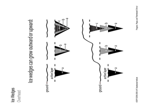
Polygons, Pingos, and Themokarst! Oh MY!
Students complete activities to learn about the common land features in Alaska. In this land study lesson, students study an overhead for permafrost features. Students define ice wedge polygons, thermokarst, and pingos. Students also...
Curated OER
To Protect Your Streams, Protect Your Mountains
Students build and experiment with a watershed to understand the effects of pollution. In this movement of water lesson, students work in groups creating rock formations and change the viscosity of the liquids falling down the mountain....
Curated OER
Mapping The Ocean Floor
Young scholars explore and analyze the bottom structure of underwater habitats. They describe and explain what can't see through the collection and correlation of accurate data. Learners assess that technology is utilized as a tool for...
Curated OER
Exploring Landforms
Second graders discuss the different types of landforms throughout the world. They pick one and research and present it to the class.
Curated OER
Traveling to Texas
First graders read "Where the River Begins" by Thomas Locker and discuss the Texan landscape. They use construction paper to make suitcases and then fill them with types of Texan landforms and scenery they might see on a trip to Texas.
Curated OER
Geography of Vietnam
Ninth graders examine the geography of Vietnam. For this Geography lesson, 9th graders create a physical and political map of Vietnam.
Curated OER
Big Blue Sky- Based on the Montana Quarter Reverse
Students use a Montana quarter to help describe geographical features such as landforms and bodies of water. Students read an article about Montana as a group and discuss examples of landforms and bodies of water. After reading,...
Curated OER
Geography: Map Making
Students, working in groups, share notes and maps collected during a study of the Lewis and Clark Expedition. They draw large composite maps of the western United States on butcher paper including land formations, bodies of water, and...
Curated OER
The Geophysics And Cultural Aspects of the Greater Antilles
Students determine location by using longitude and latitude. They measure to the minute longitude and latitude of a place and select a body of land and determine its location. They approximate time zones by using every 15 degrees of...
Curated OER
The Ocean: A Watery World
Students discuss the proper clothing for the season. They make wind chimes to use as an indicator of movement of the air and observe and identify the various cloud formations. They determine the basic rules of storm safety and discuss...
Curated OER
Geography: Mapping Neighborhoods
Pupils examine their neighborhoods and draw maps reflecting land use. In addition, they make predictions about their community's future. Students also consider the impact of business and industry on their communities and predict ...
Curated OER
Getting to Know the Seven Continents
Young scholars are introduced to basic map and globe skills. Using the internet, they identify and locate the seven continents and complete a blank map to reinforce the names of the continents. They also distinguish between land masses...
Curated OER
Our 50 States
Students identify the location of the 50 states using an interactive map. They practice geography skills by playing a fun game. Pupils become familiar with the state abbreviations for the US states. Students become familiar with the...


