Curated OER
Location
Students explore the tools used by Columbus to chart his latitude. They study the change of a location over time.
Curated OER
Seeking a Fortune in 18th Century Maritime Boston
Study the Revolutionary War era practice of recruiting seamen to prey upon the British shipping industry, and discuss the impact this practice had on the Colonial war efforts. Learners read and interpret recruiting advertisements for...
Curated OER
A Good Foundation
Students examine how regional geology affects bridge foundations. In this physical science lesson, students explore how bridge types are constructed for different purposes.
Curated OER
Organizing A Persuasive Speech
Have the class listen to a lecture on persuasive speeches. They practice outlining and detailing the components of a persuasive speech. The lecture outline also includes suggestions for researching a topic or thesis, organizing the...
Stanford University
King Philip's War
King Philip's War was the crescendo of a violent period between the Pequot and English colonists. Using documents from English settlers, including a contemporary report on the conflict, learners explore the little-known period. They then...
Curated OER
The Fact Finders
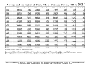
Students analyze agricultural data and make predictions about events in history. In this history instructional activity, students correlate the relationship between historic events and issues in agriculture to see if there is a...
Curated OER
George Washington
In this George Washington worksheet, students read information about George Washington's life and answer comprehension questions,. Students answer fourteen short answer questions.
Curated OER
George Washington and the First Census of Agriculture
Sixth graders compare modern agricultural statistics with those that are extracted from a primary source letter of George Washington. They complete worksheets and discuss what they have learned.
Curated OER
Cookie Topography
Students construct a cross section diagram showing elevation changes on a "cookie island." Using a chocolate chip cookie for an island, they locate the highest point in centimeters on the cookie and create a scale in feet. After tracing...
Curated OER
What can we learn about England in the 11th Century?
Learners read source documents to find information about England in the 11th century. In this England in the 11th century lesson, students analyze and answer questions based on a source document.
Curated OER
MAPS AND TOPOGRAPHY
Students analyze the details of a topographic map and create one of their own by utilyzing a map of elevations.
Curated OER
Trash Bashing
Students define trash, garbage, or solid waste, discuss ways of disposing of trash, list examples of biodegradable materials, and have trash relay race in order to sort trash into appropriate containers labeled biodegradable, reusable,...
Curated OER
Reading Comprehension/history: George Washington
In this George Washington activity worksheet, students read a one page information sheet about George Washington. Students put 10 events from his life in correct order. Then students answer 4 critical thinking questions.
Curated OER
Soil, Designing the Small Farm of the Future
Students examine the history of farming. In this environmental farming lesson, students explore the web and complete a variety of activities in order to understand the necessity of local, sustainable, and small farms for the future....
Curated OER
Preparation and Transition to Two-Column Proofs
Students investigate proofs used to solve geometric problems. In this geometry lesson, students read about the history behind early geometry and learn how to write proofs correctly using two columns. The define terminology valuable to...
Curated OER
Say Cheese
Students examine the differences in the working and eating conditions between the late 1800s and today. They engage in an Internet Quest for information on cheese which culminate in a hands-on cheese-making experience and tasting activity.
Curated OER
The Earth Moves Under My Feet
Students study earthquakes, monitor seismic activity using the Web, and plot real-time activity. They examine movement of the Earth's tectonic plates. They create an earthquake preparedness project.
Curated OER
Building an Empire Mapping China
Students create travel brochures of China's nine regions and make a bulletin board display with them.
Curated OER
Navigating by the Numbers
Students observe how math is important in navigation and engineering. They study how surveyors use math and science to calcute, count, measure, label, and indicate distances on a map. They estimate specific distances.
Curated OER
Design an Island
Students explore islands. They create a two- or three-dimensional map of an island. They explain how the topography of an area influences the location of water sources, ecosystems, and human settlements. Lesson includes adaptations for...
Curated OER
The Other Americans
Students explain the concept of culture and identify the components of a culture. They describe the characteristics of selected immigrant groups and the conditions they faced upon arrival in the United States. Students analyze the...
Curated OER
The Mission of Lewis and Clark
Young scholars comprehend the various aspects of the Lewis and Clark expediton. They complete an idea web. Students work in small groups. They recall some important aspects of the Lewis and Clark expedition by performing the Corps of...
Curated OER
What's In Your Stream?
Students conduct hands-on fieldwork in order to investigate water quality of a nearby stream. They discuss watersheds and how it affects water quality as well as identify any causes of changes or pollution in the area water before...
Curated OER
People Change the Landscape
Learners examine ways in which humans have brought change to the natural environment. In this ecology and literacy activity, students listen to the book Island Boy by Barbara Cooney. Learners observe and define map-reading vocabulary as...
Other popular searches
- Land Survey Math
- Public Land Survey
- Land Survey Construction
- Land Survey System
- Land Surveying Math
- History of Land Surveying
- Land Survey Math Measurement
- Geometry Land Surveying
- Land Surveyor
- Geometry and Land Surveying
- Land Surveying Egypt


