Curated OER
Boston Harbor Cruise: A Shoreline Survey
The students take a harbor cruise, photograph, and draw shore line features attending to evidence of human impact/consequences, and its cost on marine/land animal habitats vegetation, weather patterns, signs of erosion, and the water...
Messenger Education
Exploring Exploring
The reason people first began trading was because of their desires for objects other societies possessed. In the activity, classes discuss why exploration has been a common thread in all societies and where these desires have taken...
Curated OER
Change Since 1609
Students recognize how the climate of the Hudson Valley has changed since the last glaciation. They explain these changes using a reconstruction of the land use changes in the Hudson Valley composed of confetti, Ziploc bags and other...
Curated OER
Geometry of Exploration: Eyes Over Mars
Students research how engineers and scientists generate linear and angular measurements with geometry to survey the Earth and Mars. They assess how geometric shapes affect navigation. A surveyor comes to the classroom and explains how he...
US Geological Survey
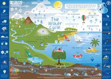
Water Cycle Poster
How many parts make up the water cycle? How many things on Earth rely on water as a system? Learn more about the water cycle in an informative and colorful poster. Print and hang, or project the graphic in the classroom for optimal use.
Curated OER
I Know Where You Are!
High schoolers study what a GPS is and use it to challenge themselves and find positions on a map. In this investigative instructional activity students find various points on a map using a GPS system and answer questions on a...
NOAA
Watching in 3D
Bring the ocean floor to life! Earth science scholars discover the process of deep sea mapping in the third installment in a series of five lessons about ocean exploration. The teacher's guide includes helpful resources, worksheets, and...
Curated OER
Water Walk
Students conduct a visual survey to discover information about local land use and water quality; document their findings by mapping and profiling the water body; and use this initial investigation to raise questions about local land use.
Curated OER
Mapping My Community
Ninth graders are introduced to GPS technology. They complete fieldwork as they visit a specific area of their community to identify and map types of land use in the surveyed area. They use the collected data to create a digital map.
Curated OER
Can You Catch the Water?
Students work together to construct a model of a water catchment basin. They survey water patterns and complete experiments to see where rain travels and collects. They discover how engineers design structures that help with drainage.
Curated OER
See That Sound?
Learners study sonar and will explain the concept of it and its major components. For this design lesson students build a low-cost sonar system.
Curated OER
To Dig or Not to Dig: The Stadium Showdown
Students examine an ethical public dilemma. In this cultural resource lesson, students role play to examine their personal beliefs regarding the protection of cultural resources. They evaluate possible actions they can take to protect...
University of Wisconsin
Follow the Drop
Young surveyors look for patterns in water flow around campus. Using a map of the school (that you will need to create), they mark the direction of the path of water. They also perform calculations for the volume that becomes runoff. The...
Curated OER
Location
Students explore the tools used by Columbus to chart his latitude. They study the change of a location over time.
Curated OER
Faulty Movement
Students discover the faults throughout the Earth. They describe the different types of faults and how they are related to earthquakes. They build models of the faults.
Curated OER
Earthquakes
Students observe the melting of ice. In this phase change lesson, students observe ice as it melts. They discuss the process and create a Venn diagram comparing water and ice.
Curated OER
Where Is That Place?
Students determine the difference between a country, state, and a city while recording the weather conditions for their school in Nebraska. They examine weather for another school in the state while practicing using weather equipment to...
TeachEngineering
Teach Engineering: Can You Catch the Water?
Students construct a three-dimensional model of a water catchment basin using everyday objects to create hills, mountains, valleys and water sources. They experiment to see where rain travels and collects, and survey water pathways to...
US Geological Survey
Usgs: Earth Surface Dynamics (Research Activities)
This site from USGS provides several activities to help understand the interrelationships among earth surface processes, ecological systems, and human activities. Also included are links to new findings and programs concerning Earth...


