Curated OER
So You Would Like a Wind Farm, Eh?
Students collect and analyze data correctly. In this statistics lesson, students use central tendencies to analyze collected data. They calculate where a wind farm will be placed, based on the data.
Curated OER
Lesson: Journey of a Tree
Third graders explore the operation of a Christmas farm and how trees are shipped. After taking a tour of a Christmas tree farm and researching transportation, location and cost issues, 3rd graders create a map to show the distribution...
Curated OER
Cookie Topography
Learners construct a cross section diagram showing elevation changes on a "cookie island." Using a chocolate chip cookie for an island, they locate the highest point in centimeters on the cookie and create a scale in feet. After tracing...
Curated OER
MAPS AND TOPOGRAPHY
Students analyze the details of a topographic map and create one of their own by utilyzing a map of elevations.
Curated OER
Preparation and Transition to Two-Column Proofs
Students investigate proofs used to solve geometric problems. In this geometry lesson, students read about the history behind early geometry and learn how to write proofs correctly using two columns. The define terminology valuable to...
Curated OER
Natural Inquirer Ecosystem Article Lesson
Learners discover new ways to preserve the ecosystem by completing graphic organizers. In this environmental lesson, students read an article from the Natural Inquirer in small groups and fill out a graphic organizer based on the...
Curated OER
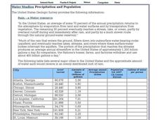
Water Studies: Precipitation and Population
In this water instructional activity, students complete the chart about precipitation and population and answer short answer questions. Students complete 14 rows in the chart and answer 4 questions.
Curated OER
Makiing Sense of the Census
Students investigate trends in agriculture. In this secondary mathematics lesson plan, students evaluate agricultural census data from 1982 to 2202 as they compare the properties of the mean and the median. Students explore...
Curated OER
GPS Art
Young scholars design their own logo or picture and use a handheld GPS receiver to map it out. They write out a word or graphic on a field or playground, walk the path, and log GPS data. The results display their "art" on their GPS...
Curated OER
Postcards from California: A Unit on Geography, Social Studies, History and California's Resources
Fourth graders examine patterns that influence population density in the various regions of California. The unit's three lessons utilize graphic organizers for the interpretation and presentation of data.
Curated OER
In the Path of the Ancients: Unearthing Formulas for Area
Students apply the formulas for the area of parallelograms and triangles. Through guided practice, students discover the correct way to apply the formulas. Working in pairs, they write their own problems featuring the formulas.
Curated OER
Collect the Eggs Game
For this Eggs Game worksheet, students cut out and put together the game board, tokens, cards and game spinner. Students try to collect the most eggs cards while playing the game.
Curated OER
What did I find?
Students excavate an artifact. In this archaeology lesson, students get a bucket filled with dirt and a broken up artifact. They work in groups to take it out and to find what its purpose was.
Alabama Learning Exchange
Alex: Land Surveying Project
This project resulted from of the collaboration of a computer aided drafting teacher, Chris Bond, and a math teacher, Lee Cable, (Hewitt-Trussville High School) to provide higher math expectations in CT and real life application in...
TeachEngineering
Teach Engineering: Navigating by the Numbers
In this lesson, students will learn that math is important in navigation and engineering. Ancient land and sea navigators started with the most basic of navigation equations (Speed x Time = Distance). Today, navigational satellites use...


