Curated OER
The Water Nearby
Learners explore water located near where they live. In this map skills maritime lesson, students use Google Maps to find their school and the body of water closest to them. Learners research the body of water and answer questions about it.
Curated OER
A Shuttle's Eye View
Students explore the goals of the Shuttle Radar Topography Mission as a springboard to exploring the topographical features of their own state or region. They synthesize their understanding of landforms and topography by mapping their...
Curated OER
Where Is Rome?
Third graders discover Ancient Rome through maps and worksheets. For this world history lesson, 3rd graders locate Rome on a world map and identify the scope of the Roman Empire. Students label an entire map of Italy after...
Curated OER
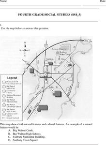
Fourth Grade Social Studies
For this social studies worksheet, 4th graders answer multiple choice questions on state maps, city maps, road maps, political maps, and more. Students complete 25 multiple choice questions.
Curated OER
By Land, Sea or Air
Students learn navigational techniques change when people travel to different places. They understand differences between navigation on land, water, air and in space. They explain the concept of dead reckoning as it applies to...
Curated OER
Principles of Flight: Where are We?
Young scholars explore the concept of topographical maps. In this topographical map lesson, students discuss how airplanes know where to fly. Young scholars use topographical maps to simulate a field trip on the computer.
World Maps Online
Introduction to the World Map
Students identify the differences between maps and globes. In this map skills instructional activity, students are shown a globe and a map and recognize the differences. Students use post-it notes to locate several locations on the world...
Curated OER
Great Basin Tribes- Use of Land for Sustenance
Students explore four Native American tribes from Nevada. In this Native American history lesson, students identify and generate important corresponding attributes of the Southern Paiute, Northern Paiute, Washoe, and Western Shoshone...
Curated OER
5th grade social studies geography
In this geography activity, 5th graders complete multiple choice questions about hemispheres, maps, cities, ecology, and more. Students complete 25 questions.
Curated OER
Land and People: finding a Balance
Students discuss "The Enemy Within: The Struggle to Clean up Cape Cod's Military Superfund Site" by Seth Rolbein by figuring out how there should be safe groundwater. In this science lesson, students pretend to be an interested party for...
Curated OER
Geography Booklet
Sixth graders explore geography terms. Students use resources to find real examples of landforms in the world. They create a map showing the landform. students label the surrounding features, countries and states. Students use each...
Curated OER
Maps with a "Spin"
Students, in groups, research and map the effects of a proposed airport three miles outside of town. They prepare a presentation based on a set of maps they make and explains its different points of view from the viewpoints of the town...
Curated OER
Common Themes
Tenth graders test usefulness of a model Earth by comparing its predictions to observations in the real world. In this landforms lesson students construct an island from a contour map using model clay then analyze the landscape...
Curated OER
Where in the World Is ...
Students locate and place countries and continents on a large map using tag board and yarn. They locate a new geographic location on the map each morning.
Curated OER
Land Grant Colleges
Students are introduced to the concept of land grant colleges which allowed agriculture to be brought into education. As a class, they create a timeline and compare and contrast the land grant colleges of 1890 and 1892. They use maps...
Curated OER
From Forest to Farm and Back Again
Young scholars review and discuss a given set of questions regarding ecosystems. They analyze essays, maps and historical documents on timber harvesting and regeneration and then complete worksheets.
Curated OER
Canada's Landform Regions
Students identify and describe the processes that created the landform regions in Canada. They map the regions and research one region to discover more about it. They present their findings to the class.
Curated OER
Canada's Landform Regions
Students use a atlas to identify and describe Canada's Landform region. Using the information they collect, they create a thematic map of the region and describe all of the physiographic regions and the processes that formed them. They...
Curated OER
What do Maps Show?
Eighth graders practice the skill of reading maps. In this geography lesson, 8th graders participate in a classroom lecture on how to read a map.
Curated OER
Landform Tag
Third graders explore various landforms. They play landform tag while exploring the various types of landforms that are found within the United States. Students locate landforms as they are called by the teacher.
Curated OER
Landforms By Hand: Geography, Map Skills
Young scholars experiment with landform vocabulary by using their own hands and a bar of soap as media.
Rainforest Alliance
Protecting the Critical Habitat of the Manatee and Loggerhead Turtle
Explore ocean habitats with a lesson that showcases the home of manatees and loggerhead turtles in Belize. Here, pupils compare and contrast the homes of ocean animals to those of humans, listen to an original short story about...
Curated OER
Plate Tectonics: Sixth Grade Lesson Plans and Activities
Here is a set of pre-lab, lab, and post-lab lesson plans on plate tectonics. After completing the previous labs on volcanoes and earthquakes, sixth graders use the gained knowledge to explore plate boundaries and the movement of...
Curated OER
LRO and the Apollo-11 Landing Site
In this Apollo-11 landing site worksheet, students read about the NASA Lunar Reconnaissance Orbiter (LRO) that will collect images at a higher resolution than ever before. Students study a grid showing the lunar landing site from Apollo...


