Scholastic
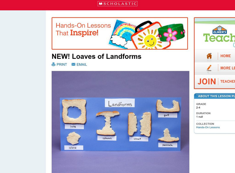
Scholastic: Loaves of Landforms
This is a comprehensive lesson plan to teach primary students about landforms. A foundation in geography begins with an understanding of the terms geographers use to describe the features of Earth. Help students grow their vocabulary and...
Science Education Resource Center at Carleton College
Serc: State Map Poster
This is a project where young scholars pick a state, study its landforms and data about its geology, and produce a poster that outlines how the state's geography evolved over time. An example of such a poster is provided on a...
Better Lesson
Better Lesson: What Shapes the Land?
In this activity, the teacher will read a book about different landforms. The children will learn about the features of the landforms and how they were shaped by natural forces. Then text features will be discussed. The children will...
Discovery Education
Discovery Education: Unique Landforms
The title of this lesson is somewhat misleading and may be a mismatch, as well as the grade levels noted. It is really about transportation. Students conduct extensive research, both online and by phone, and compare various methods of...
Other
Bscs: Earth's Changing Surface Lesson 2: Landform Detectives
Using relief maps, students will learn that landforms can be different from one place to another. Included are a minute-by-minute lesson plan, activities, and teacher discussion points and questions.
Other
Bscs: Earth's Changing Surface Lesson 1: Our Land
This hands-on lesson focuses on the land and its many different types of landforms and bodies of water. Included are a minute-by-minute lesson plan, activities, and teacher discussion points and questions.
Other
Bscs: Earth's Changing Surface Lesson 3: Grand Canyon Explorers
Students will learn that landforms can change over time in this lesson. Included are a minute-by-minute lesson plan, activities, and teacher discussion points and questions.
Science Education Resource Center at Carleton College
Serc: Mn Step: Student Created Landform Maps With Glacial Emphasis
An activity where learners work together to make topographic maps of a local park. The map must include a key and the grid locations of landforms in the park.
TeachEngineering
Teach Engineering: Sea to Sky
In this lesson, students learn about major landforms (e.g., mountains, rivers, plains, valleys, canyons and plateaus) and how they occur on the Earth's surface. They learn about the civil and geotechnical engineering applications of...
Alabama Learning Exchange
Alex: The Earth's Changing Surface
During this unit, students will identify the various landforms found on the earth's surface. Also, students will describe how these landforms are created and changed by the natural forces within the earth and on its surface, as well as...
National Association of Geoscience Teachers
Quaternary Glacio Fluvial History of the Upper Midwest Using Anaglyph Stereo Maps
Students examine the anaglyph stereo map and use textures to generate a surficial geology map of the Upper Midwest. They can then interpret the textures in terms of landforms, geomorphic features, and earth-surface processes, as well as...
Science Education Resource Center at Carleton College
Serc: Geologic Photo Field Trips for Introductory Physical Geology
Students participate in a series of virtual geology field trips by observing and describing rock outcrops, geologic structures, and landforms in field based photographs.
Alabama Learning Exchange
Alex: Forces That Change the Land
Students will use websites and other resources to find information about the following landforms: mountains, canyons, and valleys.
Crayola
Crayola: Airplane View
Show off your knowledge of geography. Draw your state, its neighbors and indicate notable landforms as if you were viewing them from the window of an airplane.
Utah Education Network
Uen: Weathering Landforms
This lesson plan will demonstrate the mechanical weathering process known as frost wedging and the biological weathering process caused by plants. The materials required include plaster of Paris, balloons, seeds, paper plates and a...
Science Education Resource Center at Carleton College
Serc: Mn Step: Rock Identification and Usage
For this activity, students explore rocks using their five senses. They sort them into groups, learn about landforms, and learn how rocks are used by humans. Their discoveries are recorded in their science notebooks.
Science Education Resource Center at Carleton College
Serc: Investigating the Geologic History of Southeast Minnesota
This activity is an inquiry-based, earth science field investigation of the geology of southeast Minnesota. Students will make observations of rock outcrops and landforms in the region using maps, pictures, and field sampling, then use...
PBS
Pbs Learning Media: Hurricane Matthew Causes Weathering and Erosion
View videos and photos from the aftermath of Hurricane Matthew and see how the earth's landforms changed as a result of the heavy winds and rain. Weathering and erosion made a new landform and dramatically changed the coastline....
Utah Education Network
Uen: Landforms in a Tub
For this activity, students create models in a tub or sandbox that simulate erosion caused by weathering.
National Geographic
National Geographic: Shaping the Tallest Peak on Earth
This instructional activity builds upon a National Geographic film covering George Mallory's effort to climb Mount Everest in 1924. It looks at the physical features of mountains, and the landform features of Mount Everest that present...
Science Education Resource Center at Carleton College
Serc: Mapping the Glaciers
In this activity, students will use Minnesota Geological Survey 3-D maps of the upper Midwest to trace the outlines of where they believe glaciers may have affected North America. They will identify landforms that resulted from glacial...
NC State University
The Engineering Place: Volcanoes: Viscosity Demonstration
For this instructional activity, students explore how the viscosity of lava affects the intensity of a volcanic eruption, and the resultant landforms that are created.
Science Education Resource Center at Carleton College
Serc: Sandbox Modeling
Students create landforms using layers of colored sand, then construct a topographic map and a cross-section. This is an investigation that was presented to pre-service science teachers. The format would be similar with students, with...
TeachEngineering
Teach Engineering: How Dense Are You?
Students learn about geotechnical engineers and their use of physical properties, such as soil density, to determine the ability of various soils to offer support to foundations. In an associated activity, students determine the bulk...
Other popular searches
- Landforms and Water Forms
- Canada Geography (Landforms)
- Earths Landforms
- Landforms Lesson Plans
- Landforms of Colombia
- Ocean Floor Landforms
- Definitions of Landforms
- Different Landforms
- Canada Geography Landforms
- Google Earth Landforms
- Geographic Landforms
- Landforms on Neptune


