Polk Bros Foundation
Answer the BIG Question with Cited Examples and Evidence
Close up your unit of study with an examination of one of the guiding or essential questions as it relates to what your class has studied and other research. Class members first write down the question. Then they note down information...
CK-12 Foundation
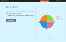
Domain, Range, and Signs of Trigonometric Functions: Sine and Cosine
Is there a relationship between the sign of sine and cosine and the angle on the unit circle? Scholars use an interactive to see the value of sine and cosine within different quadrants. they then use the information to determine the...
CK-12 Foundation
Direction on the Earth: Using a Compass
Navigate the world of orienteering in an informative interactive. Earth science scholars learn practical direction skills, such as proper polar coordinates and pairing compasses with maps. The interactive map allows them to practice...
Concord Consortium
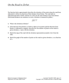
On the Road to Zirbet
The road to a greater knowledge of functions lies in the informative resource. Young mathematicians first graph a square root function in a short performance task. They then use given descriptions of towns and the key features of the...
Biology Junction
Cellular Respiration
Which food molecules must be present for cellular respiration to occur? Scholars view an informative presentation to better understand the process of cellular respiration. It details each step, focusing on the locations and the four main...
Corbett Maths
Rotations
Develop the basics of turns. A helpful video discusses the information required to perform a rotation. Afterward, the narrator shows pupils how to perform a rotation by using a piece of tracing paper to determine where the image will be...
Bonneville
A Plan for Renewable Energy Goals
The best laid plans can lead to meeting renewable energy goals. A culminating project for the unit has pupils research the amount of solar and wind energy at their locations. They set renewable energy goals and use the information they...
News Literacy Project
News Goggles: Identifying the News Source
A 25-slide presentation teaches viewers how to identify the source of stories in newspapers and online news sites. The slides show how to locate the byline where either the reporter's name or the wire service that provided the story can...
Curated OER
"Planet" Vacation
Students research a location of their choice using the internet. They list the characteristics of the location and why they chose it as their ideal vacation spot. Using maps, they pinpoint their destination and trace their route. They...
Curated OER
What I Did On My Summer Vacation
Students use the internet to research the location of their summer vacation trip. Given the demographics, they plot the location on a world map. They create a brochure using the information they collected. Using PowerPoint, they develop...
Curated OER
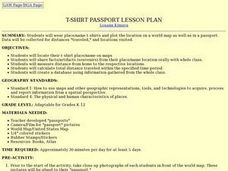
T-shirt Passport Lesson Plan
Students locate their t-shirt place/name on maps, then share facts/artifacts (souvenirs) from their place/name location orally with whole class. They create a database using information gathered from the whole class.
Curated OER
Rain Forests: A Disappearing Act?
Students examine and locate rainforests on maps, and research the patterns of their destruction. They develop a bar graph of rainfall and temperature data, write a journal entry, and research the people, animals, and plants/products of...
Curated OER
Weather Pals
Students study maps of the United States to locate weather pals from a list of schools. They communicate with Weather Pal schools through the use of closed circuit TV. Using weather data collected in their area, they exchange the...
Curated OER
Geomnemonics: Facilitating the Teaching of Social Studies Content with Geography Skills
Pupils explore how to draw a world map by hand and how to locate countries.
Curated OER
Grocery Store Field Study
Students visit a local grocery store (not a community market) to gather information about where some commonly eaten produce items come from. Once they have collected this information, locate the countries of origin on a map and research...
Curated OER
Geography With Dr. Seuss
Students read the book, The King's Stilts by Dr. Seuss and discuss the geographical information given in the book. Then they discuss and locate on a map the physical features that make up the continent of Africa. They create an original...
Curated OER
Garb and Grub Across the Globe
First graders discuss what part of the world their ancestors came from. They locate the locations on a map and discuss the differences and similarities of each continent and their people. They become familiar with the traditional...
Curated OER
The Price is Right
Students, through various activities, explore online databases. Using the internet, students explore the distributors websites. They collect specific information on selected products. An spreadsheet with price comparisons is developed....
Curated OER
Read a Map
For this word problem worksheet, 5th graders use a coordinate grid as a map to answer 6 problems. They work with ordered pairs, locate quadrants, and apply the information to find items in the zoo.
Curated OER
Where Does Our Food Come From?
Fourth graders identify the state or country that a food product came from and locate it on a map. They identify products that are grown in Hawaii and the factors important in the location of economic activities.
Rocklin Unified School District
Spanish Speaking Countries Project
Ask your class members to provide a tour of a Spanish speaking country with a brochure and flag project. Learners research their assigned country, making sure to check off each of the required pieces of information listed on the first...
Curated OER
Cruisin' the Counties: Learning Counties and Major Roads in Arizona
Students examine Arizona counties and use the themes of location and movement to develop an Arizona map.
Curated OER
Your Next Class Trip
Investigate the techniques used in a persuasive argument. Young writers compose a persuasive argument persuading their principal to take their class on a trip to the location of their choice. They then create a persuasive web site.
Curated OER
Skyscrapers from New York to California
Third graders use an online database to gather information on skyscrapers. Using the information, they choose one building and record its height and location. In groups, they design a city skyline including the skyscraper they choose....


