Curated OER
Geography of China (Tibet)
Sixth graders study the geography of Tibet. They create maps of Tibet. Students predict population, land area, water area and coastline length of the United States and Tibet. Students compare and contrast the day-to-day lives of people...
Curated OER
Japan
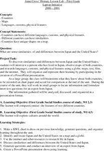
First graders investigate the similarities and differences between Japan and the United States. They develop a KWL chart, locate Japan and the U.S. on a globe, conduct Internet research on life in Japan, conduct an interview, and create...
Curated OER
Globe Game
Students are arranged into groups and are given a map or globe. Students select a location on the map. Students as yes and no questions to guess the specific place that was chosen.
Curated OER
Playing in Lesotho
Students learn about another culture. For this cultural awareness lesson, students learn about the location of the kingdom of Lesotho in southern Africa, discuss the toys used in Lesotho to those used in the United States and draw...
Curated OER
Geography A to Z: The Letter S
The letter S is the clue learners need to answer each of the seven geography questions on the worksheet. They answer questions about African, Canadian, Middle Eastern, and US geography using locations that begin with the letter S.
Curated OER
Geography and Culture
Students explore African geography, study the overall continent of Africa and its individual countries, discuss demographics, and participate in research and class activities.
Curated OER
Recipes for Foreign Foods
Upper graders choose a foreign country to research. They use the computer to locate three recipes from the country of their choice. Next, they link the information in each recipe to what they know about nutrition and food. Note: This...
Curated OER
Garb and Grub Across the Globe
First graders discuss what part of the world their ancestors came from. They locate the locations on a map and discuss the differences and similarities of each continent and their people. They become familiar with the traditional...
Curated OER
We Live in an International Community
Students locate the different countries from which their clothing originates. Using a blank map, they identify and color in those areas.
Curated OER
Influence of Beauty, The Beauty of Influence
Tenth graders explore the influence of art on modern societies. Through the internet, they assess paintings of advertisements for commercial products and social-political beliefs. Using spreadsheet software, the class compares and...
Curated OER
Where Does Our Food Come From?
Fourth graders identify the state or country that a food product came from and locate it on a map. They identify products that are grown in Hawaii and the factors important in the location of economic activities.
Curated OER
Electronic Mapping
Students identify countries, oceans, and capitals by building an electronic map.
Curated OER
Geography With Dr. Seuss
Students read the book, The King's Stilts by Dr. Seuss and discuss the geographical information given in the book. Then they discuss and locate on a map the physical features that make up the continent of Africa. They create an original...
Curated OER
Immigration and Ellis Island
Fourth graders explore family histories. In this social studies lesson, 4th graders identify the countries from which their ancestors came and locate them on a map. Students discuss the role that Ellis Island played in immigration in the...
Curated OER
Telecommunications and the Whole Language Program
Young writers use technology and other media to research information on a chosen topic. They explore countries where keypals and e-mail friends are located. Using their writing skills, they correspond with their e-mail friend and...
Curated OER
Puerto Rico: The 51st State?
Students explore Puerto Rico. In this Puerto Rico current events lesson, students conduct a Webquest to answer questions about Puerto Rico's culture. Students discuss whether Puerto Rico is a country or a state, and defend...
Curated OER
Iraq, Where's That?
Students identify the Middle Eastern countries on the map and the oil-producing countries of OPEC in the region. They examine whether the presence of important producing oil fields qualifies as a characteristic of this region.
Curated OER
Where Am I?
Students identify volcano locations by latitude and longitude. They analyze a world map, and complete a "Volcano Event Locations Chart."
Curated OER
"Planet" Vacation
Young scholars research a location of their choice using the internet. They list the characteristics of the location and why they chose it as their ideal vacation spot. Using maps, they pinpoint their destination and trace their route....
Curated OER
Changing Borders
Middle schoolers explain that the boundaries between countries are not permanent, then analyze current events and stories as examples of cooperation and conflict. They describe a place using physical and human characteristics.
Curated OER
Rain Forests: A Disappearing Act?
Students examine and locate rainforests on maps, and research the patterns of their destruction. They develop a bar graph of rainfall and temperature data, write a journal entry, and research the people, animals, and plants/products of...
Curated OER
What I Did On My Summer Vacation
Young scholars use the internet to research the location of their summer vacation trip. Given the demographics, they plot the location on a world map. They create a brochure using the information they collected. Using PowerPoint, they...
Curated OER
One Dollar Around the World
Twelfth graders collaborate via ePals with another student from another country. They compare the value of a dollar with its power of acquisition in other countries. They list one dollar items and find the corresponding price in other...
Curated OER
Where Does It Come From?
Pupils explore where agricultural commodities used in snack foods are grown. They choose a snack food and locate the top five states that produce the food that the snack is made from.


